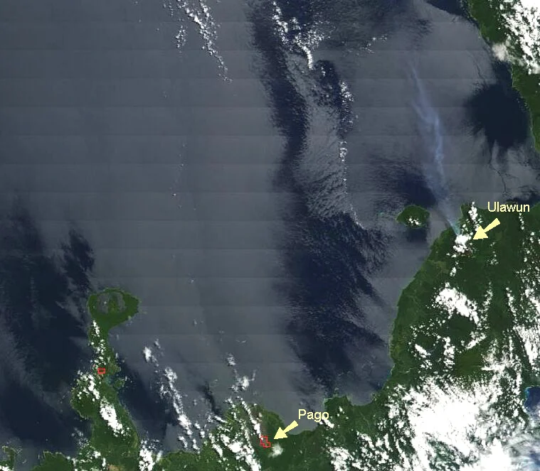
Ulawun
On June 26, 2019, at roughly 7 a.m., the sky above western New Britain turned into a nineteen-kilometer column of ash. Ulawun had woken up again - not with a whisper, but with a sub-Plinian eruption that cancelled flights into Hoskins Airport, cut the New Britain Highway in three places, and sent more than five thousand people running from their homes. The volcano that Papua New Guinea's geological survey watches more closely than almost any other had done what scientists always knew it might do. Four years later, in November 2023, the alert level climbed to four, the top of the scale, and a plume drifted 520 kilometers to the west before the mountain quieted again.
A Mountain on the Shortlist
Of the world's roughly 1,500 active volcanoes, the international scientific community has singled out just sixteen for special scrutiny. They call them the Decade Volcanoes, and Ulawun is one of them. The criteria are unsentimental: a history of large, destructive eruptions, and enough people living close enough to die in one. Ulawun meets both. At 2,334 meters, it is the highest peak on New Britain and the second-highest in the Bismarck Archipelago, a perfect cone of basalt and andesite that rises almost straight out of the sea on the island's northern coast. Several thousand people farm and fish in the villages at its base. When the mountain stirs, they are the ones who pack bags and head for the roads before the ash clouds close in.
Tectonic Machinery
Ulawun is not a quirk of the landscape. It is the surface expression of something enormous happening underneath the sea floor. The Solomon Sea Plate is sliding beneath the South Bismarck Plate along the New Britain subduction zone, dragging ocean crust down into the mantle. Water cooks out of the descending rock, melts the material above it, and that melt rises as magma. Ulawun is one of the chimneys. It is also, remarkably, one of the world's great point sources of sulphur dioxide. Studies have measured roughly seven kilograms per second of SO2 pouring from the summit - around two percent of all the SO2 humans and volcanoes together pump into the atmosphere each year. One mountain. Two percent of a planet's output.
A Long Record of Reckonings
The written history of Ulawun begins in 1700, when the English buccaneer-turned-navigator William Dampier sailed past New Britain and noted the volcano's activity in his logs. Dampier's observation became the first of at least twenty-two recorded eruptions in the centuries since. The modern record is denser because the modern instruments are better, but the pattern is the same one Dampier saw: long stretches of relative calm broken by ash columns, lava flows, and panicked evacuations. The 2019 event was classified as sub-Plinian, a category named for the historian whose uncle died watching Vesuvius. The 2023 sequence produced pyroclastic flows down the northwest and south flanks - the kind of density current that, at ground level, destroys almost everything in its path.
Living in the Blast Radius
What does it mean to farm coconut palms on the slope of a Decade Volcano? The answer, for the people of West New Britain Province, is that life continues because it must. The soil on Ulawun's flanks is volcanic and rich. Cocoa, coconuts, and small gardens thrive. Hoskins Airport connects the region to Port Moresby and the outside world. The New Britain Highway threads along the coast at the mountain's feet. When alert levels rise, evacuations begin; when they fall, people come home and begin again. Papua New Guinea's geological survey keeps watch from seismic stations and satellite data, and Ulawun keeps doing what stratovolcanoes do. The mountain will erupt again. The question is only when, and whether warning comes in time.
From the Air
Ulawun sits at 5.05 degrees south, 151.33 degrees east, on the north coast of New Britain in Papua New Guinea's West New Britain Province. The summit reaches 2,334 meters (7,657 feet). Hoskins Airport (AYHK) is the nearest major field, roughly 130 kilometers southwest. Rabaul is to the east on the opposite end of New Britain. Pilots should check recent volcanic ash advisories before operating in this region - Ulawun's eruptions have put ash plumes at flight levels above FL500 and have closed Hoskins for days at a time. A safe viewing altitude well clear of the summit and upwind of any current activity is essential.
Nearby Stories
- Henry Reid Bay 11 km away
- Landing at Jacquinot Bay 37 km away
- Kerevat 47 km away
- Bismarck Archipelago 80 km away
- Kimbe 80 km away
- Siege of Toma 99 km away
- Vitu Islands 169 km away
- Japanese cruiser Sendai 290 km away