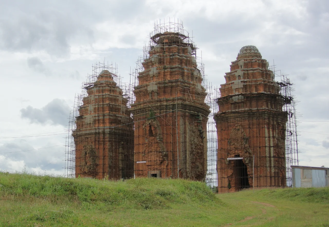

Vijaya — The Lost Capital of Champa
The Sanskrit name means "victorious," and for a time, it was. Vijaya — also called Vijayapura — served as the capital of the Kingdom of Champa from the 12th century until early 1471, when a Vietnamese army from Đại Việt besieged the city and broke through its walls. What they found inside, according to the Vietnamese grand chronicles, was a city of perhaps 70,000 people. What they left behind was rubble. The Cham people's civilization did not end that day — smaller principalities survived, and descendants live in Vietnam and Cambodia still — but Vijaya itself was completely destroyed, and the land that had been the center of a kingdom passed permanently into Vietnamese hands.
A Kingdom Built on Water and Trade
Vijaya's location was not accidental. The city grew on the fertile lowland plain along the lower Côn River in what is now Bình Định Province — an unusual expanse of level, well-watered agricultural land in a country dominated by mountains. To the east, near the river's estuary, the Cham developed Cảng Thị Nại, one of the kingdom's major ports, positioned to catch trade flowing in off the East Sea. To the west, the river ran up into the Central Highlands, where highland peoples traded luxury goods — eaglewood above all, a fragrant resin prized across maritime Asia — that Champa exported to China and beyond. The city sat at the junction of sea trade and highland forest, a commercial position that made it worth defending.
Centuries of War and Survival
Champa was never at peace for long. In the 12th century, the Khmer king Suryavarman II subdued Vijaya, deposing Jaya Indravarman III in 1145. Jayavarman VII later dominated the city, relying on Cham allies for his campaigns in both Angkor and across Champa. Vietnamese forces probed south repeatedly — a raid in 1069 reached somewhere on the central coast, though historians debate whether it actually struck Vijaya. An attempted Vietnamese siege in 1403 failed when the attackers ran out of food and withdrew. For almost 70 more years, the two kingdoms managed an uneasy coexistence. Then, in early 1471, Đại Việt launched its final campaign. The trigger, as historians interpret it, was Champa seeking Chinese military reinforcements to pressure its northern neighbor. Vijaya fell after a one-month siege. The city was not surrendered — it was destroyed.
What Architecture Reveals
Vijaya's buildings set it apart from other Champa centers. Most Cham architecture used brick alone; Vijaya's towers combined stone and brick, a technique that scholars attribute to Angkorian influence. The Dương Long towers, dating to the late 12th and early 13th century, are among the tallest surviving Hindu religious structures in all of Southeast Asia. The Cánh Tiên tower, built between the late 13th and early 15th centuries, still stands within the ruins of the old citadel — Thành Đồ Bàn — near modern An Nhơn. These towers were not decorative; they were the religious centers of a civilization, places where the Cham people's Hindu and later syncretic faith was practiced across centuries. To stand at the base of Dương Long today is to stand in the shadow of something enormous that the history books compress into a few paragraphs.
The People Behind the Stones
The 15th-century Vietnamese chronicles that described Vijaya's fall recorded two figures for the city's population: 2,500 households — roughly 10,000 people — and, in a second, more careful account, 70,000. Historians favor the larger number. These were not abstractions. They were Cham men, women, and children who had lived in this city, worshipped in its temples, traded at its port, farmed its surrounding fields. Their descendants — the Cham people — number roughly 400,000 in Vietnam and Cambodia today, many still practicing a form of Hinduism or Islam that traces to the same civilization. The stone lions discovered in the Bả Canh area of nearby Đập Đá in 1992, now recognized as national treasures, were carved by Cham artisans in the 11th or 12th century. They survived because the earth kept them.
Layers Upon Layers
History did not stop at Vijaya after 1471. Within the old Champa city walls, the Tây Sơn dynasty later built the Hoang De citadel — its ruins still visible — layering Vietnamese imperial history atop Cham foundations. The flat plain around modern An Nhơn became Vietnamese farmland, then a battlefield during the French colonial period, then again during the American war. Phù Cát Airport, 10 kilometers to the north, was an American air base from 1966 to 1975. All of this history presses close in a compact piece of lowland Vietnam. The Cánh Tiên tower stands a few kilometers from a working Vietnamese airfield, and the stone lions that once guarded a Cham palace are now housed in a museum. The victorious city lives on in its ruins.
From the Air
Vijaya's ruins — centered on the Thành Đồ Bàn citadel area — lie at approximately 13.9287°N, 109.0751°E in An Nhơn, Bình Định Province. Phù Cát Airport (IATA: UIH, ICAO: VVPC) is roughly 10 km to the north, making this area a natural waypoint on the approach from the north. At 3,000–5,000 feet, the Côn River delta spreading east toward the sea is clearly visible, and the brick Cham towers — notably Cánh Tiên and the Bánh Ít complex to the south — appear as small reddish-brown structures rising from the green agricultural plain. The Dương Long towers are visible in the hills of Tây Sơn district to the west.
Nearby Stories
- Paris Davis 26 km away
- Sông Cầu 29 km away
- Kon Ka Kinh National Park 31 km away
- Battle of Mang Yang Pass 41 km away
- Chư Yang Sin National Park 95 km away
- Battle of the Paracel Islands 327 km away
- Kashmir Princess 406 km away
- South China Sea 421 km away