Western Bahr el Ghazal
In the 1860s and 1870s, the population of this region fell by 75 percent. Not over a century - over a few brutal decades. Western Bahr el Ghazal, a state of 93,900 square kilometers wedged into South Sudan's northwestern corner against the Central African Republic and Sudan's Darfur, was at the center of the great southern slaving raids of 19th-century Mameluk Egypt. The dead numbered in the hundreds of thousands. The survivors fled, died of epidemics, or were carried north in chains. The land still holds the shape of that emptying.
Dar Fertit, the Land the Slavers Called Theirs
Raga County, in the west of the state, is the southern part of what was historically called Dar Fertit - a term Arabic-speaking slave-traders used for the non-Muslim peoples whose villages they raided. It is the only part of South Sudan with a significant number of Muslims and Arabs, a demographic legacy of 19th-century Egyptian expansion and the northern Baggara Arabs' seasonal cattle migrations. The Baggara belt - a 1,400-kilometer strip of the central Sahel - crosses the northern part of Raga County. Cattle-herding Arab tribes still move through on their annual circuits, a pattern that predates the slave trade and outlasted it. The population, which once stood around 1.6 million, had collapsed to about 400,000 by the 1880s. Colonial census-takers later recorded numbers lower still. The peoples who were taken - the Balanda, the Ndogo, the Kresh, the Bai - often knew the names of their captors long after those captors had vanished from history.
A Mosaic of Peoples
Today's ethnic map of Western Bahr el Ghazal is one of the most layered in the country. The Luo live here, along with the Balanda (who are not a single people but several - Balanda Boor, Balanda Viri, Balanda Uoyu Juku - sharing only their linguistic prefix), the Ndogo, the Kresh, the Bai, and the Baggara Arabs. Despite a widespread assumption in the colonial literature, there is in fact no single people called the 'Fertit' - the word was always a category imposed from outside, lumping together the many small ethnic groups the slavers considered fair game. The cultural diversity that survived the raids is a testament to communities that chose to remain distinct even when an outside power found it convenient to lump them together.
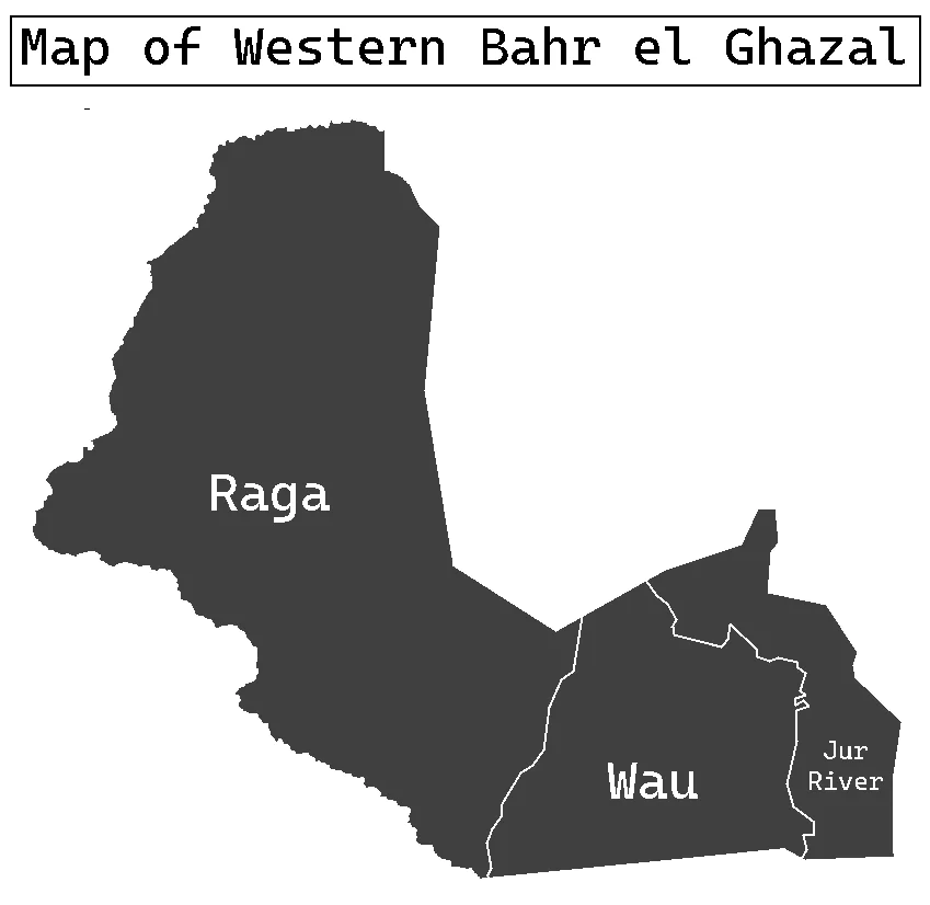
Wau, the State Capital
Wau, on the Jur River, is the capital - a trading hub that began as a French fort, became a slavers' zariba, then an Anglo-Egyptian administrative center, and now serves as the regional government seat. Raga, to the west, anchors the other major population center. Mapel, Deim Zubeir, Udici, and the smaller villages scattered along the seasonal watercourses complete the sparse settlement pattern. The three counties - Wau, Jur River, and Raga - further subdivide into Payams and then Bomas in the layered administrative structure South Sudan inherited from its British colonial past. Kafia Kingi, in the far north, is disputed territory that both Sudan and South Sudan claim; Sudan administers it as part of South Darfur.
Between Two Waters
The Lol River crosses the state, draining eastward toward the Nile system. To the north the terrain rises toward the Darfur plateau. To the south it drops toward the equatorial forests of Western Equatoria. This transitional geography - Sahel savanna meeting wetter tropical country - has always made Western Bahr el Ghazal a zone of movement: cattle herders coming south in the dry season, farmers staying year-round in the wetter south, traders moving in every direction. The 2020 peace agreement reestablished Western Bahr el Ghazal along with the other nine original states, ending a five-year experiment in splitting it into Lol State and Wau State. Sarah Cleto Hassan was appointed governor - the only woman among South Sudan's eight governors at the time.
From the Air
Flying over Western Bahr el Ghazal you see a landscape that tells its history if you know how to read it. The population centers cluster along the rivers - Wau on the Jur, Raga on its own seasonal watercourse - while vast stretches between show only scattered compounds and occasional dirt tracks. In the wet season the Lol and its tributaries run full and the country greens. In the dry months the savanna browns and the burn-scars from pastoralist fires darken the ground in mosaic patterns. The borderlands with Darfur and the Central African Republic are visible only as political lines - the land itself does not change at the frontier. The Sahel's immense flatness extends in all directions, and the sky at altitude is enormous.
From the Air
Coordinates: 7.88°N, 25.87°E. Recommended viewing altitude: FL350-FL400 for full state overview. Visible landmarks: Lol River (east-flowing), Wau urban area to the southeast of state, Raga in the west, border ridge with CAR. Nearest airport: Wau Airport (HSWW/WUU). Other references: Juba International (HSSJ/JUB) ~700 km southeast. Weather: Sahelian tropical savanna; wet May-October; extremely hot and dusty March-April.
Nearby Stories
- Dār Fertit 33 km away
- Aroyo, South Sudan 84 km away
- Northern Bahr el Ghazal 117 km away
- Ironstone Plateau 211 km away
- Chinko 229 km away
- Georges Le Marinel 255 km away
- Ouanda Djallé 291 km away
- Léon Hanolet 302 km away