
White Rock Pier
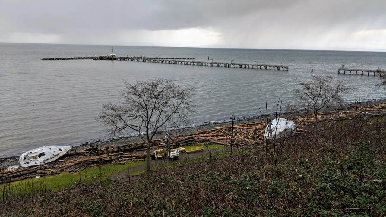
Sailboats make poor battering rams, but on the night of December 20, 2018, a windstorm over Semiahmoo Bay turned them into exactly that. Gusts tore vessels from their moorings and drove them beneath the White Rock Pier, where the swell lifted them up through the deck from below. By morning a long section of the middle of the pier was simply gone, its planking scattered along the beach, and a pedestrian stranded out on the seaward end had to be taken off by the Coast Guard. It was the most spectacular failure in the life of a structure that has been arguing with the weather since the day it was built.
Built for Steamships, Broken by Winter
The first pier here, put up in 1912, was barely a pier at all - a floating dock of roughly 300 feet, the sort of thing a small seaside town builds when it has more ambition than budget. Winter storms pulled it apart in 1913. Its replacement was meant to last. The Great Northern Railway had run its line along the beach, opening White Rock and nearby Crescent Beach to day-trippers from Vancouver and New Westminster, and the town wanted somewhere for steamships to tie up in deep water. Construction finished in August 1914. Then the First World War began, and the official opening slid back to November 14 of that year. The new pier reached about 800 feet into the bay. A federally approved extension in 1915 carried it out to 1,542 feet - 470 metres, the length it still holds.
Drag Races on the Deck
Wooden piers burn, and this one came close more than once when buildings near the shore end went up in flames. It survived those. What it survived less gracefully was its own popularity. Through the 1940s and 1950s the Dolphin Restaurant operated out on the deck, and cars were permitted to drive the length of the structure - an arrangement local teenagers interpreted as an invitation. They held drag races on it. Every run worked fastenings loose and split planking in a pier already being hammered from underneath. Storm after storm forced repairs, funded by an awkward mix of federal money and community fundraising, until 1953, when a permanent rock breakwater was completed at the seaward end to absorb the worst of the waves before they reached the pilings.
The Morning After
Rebuilding what the 2018 storm took apart was estimated at $16.2 million, a sum that would strain any city of roughly twenty-two thousand people. Governments covered much of it; residents covered a good deal of the rest, as they had in every earlier crisis, through fundraising drives to close a multimillion-dollar gap. The pier reopened in 2019. That pattern - damage, appeal, repair - is arguably the truest thing about the structure. White Rock has never had a pier because a pier was easy to maintain here. It has one because enough people kept deciding, decade after decade, that walking half a kilometre out over the water was worth paying for again.
The Rock That Named the Town
The pier takes its name from a boulder sitting on the beach a short walk to the east. It is a glacial erratic - a slab of granite carried south and dropped here by ice - and it weighs some 486 tons. Nineteenth-century mariners used it as a navigational mark, and it earned its colour honestly: generations of seabirds roosting on it kept the surface white. Now the city's parks crews do that work instead, repainting the rock roughly monthly and scrubbing off the graffiti it attracts. Between the rock and the promenade runs the old Great Northern alignment, still in service. BNSF freight trains rumble along the beach several times a day, a working rail corridor threaded between the sunbathers and the sea.
Longest in Canada, Probably
A sign on the pier declares it the longest in Canada. The claim is contested - the Quai de Portneuf, on the St. Lawrence in Quebec, is built the same way and reasonable people disagree about which measurement counts, particularly when causeways like the one at the Tsawwassen ferry terminal are thrown into the comparison. White Rock has kept the sign up anyway. In 2024 the city finished something that matters more than the title: an accessibility mat laid the length of the deck, smoothing the gaps and bumps between the planks so that people using wheelchairs or walkers, and people with limited vision, can make the walk out to the breakwater like everybody else.
From the Air
White Rock Pier extends into Semiahmoo Bay at 49.0191 N, 122.8057 W, roughly two kilometres north of the Canada-United States border. A viewing altitude of 2,000 to 3,000 feet AGL frames the whole bay: the pier is a thin pale line running southwest off a beach backed by a steep, densely built hillside, with the crescent of Semiahmoo Bay curving east toward Blaine, Washington, and the Semiahmoo Spit beyond. The Peace Arch border crossing and Highway 99 lie a few kilometres inland to the east. Nearest airports are Boundary Bay (CZBB) about 20 km west, Abbotsford International (CYXX) about 45 km east, Bellingham International (KBLI) about 30 km southeast across the border, and Vancouver International (CYVR) about 40 km northwest. Marine air and low stratus are common on summer mornings and often burn off by midday; winter southeasterlies can make the approach over the bay turbulent.
Nearby Stories
- Swartz Bay ferry terminal 0.9 km away
- Maillardville 2.1 km away
- Nooksack, Washington 3.5 km away
- Galiano Island 4.5 km away
- Orcas Island 4.8 km away
- Hatzic Valley 8.2 km away
- St. Augustine's Indian Residential School 38 km away
- Everett-Pacific Shipbuilding: The Yard That Built a Floating Navy 79 km away