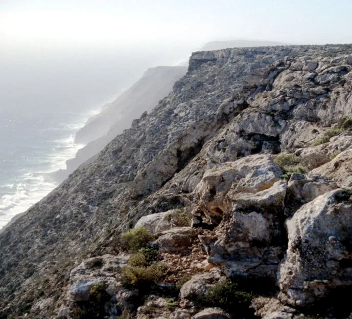

Zuytdorp Cliffs
The cliffs are named after the shipwreck, not the other way around. Somewhere along this hundred-and-fifty-kilometre rampart of limestone on the Western Australian coast, on a winter night in 1712, a Dutch East India Company trading ship called the Zuytdorp drove side-on into the rock and keeled over. She had sailed from the Netherlands the previous August, bound for Batavia with a cargo of freshly minted silver, and she never arrived. For more than two centuries no one knew where she had gone. The answer was written on this coast all along, in the form of a cliff line that now carries the dead ship's name.
A Wall Against the Ocean
There is almost nothing gentle about the Zuytdorp Cliffs. They run from just south of the Murchison River mouth at Kalbarri north to Pepper Point, below Steep Point, a near-continuous sheer face where the Indian Ocean meets the land with no beach, no harbour, no easy way down. Near Womerangee Hill the top of the cliff stands 250 metres above the sea — among the tallest coastal cliffs in Australia. The swell that rolls in here has crossed thousands of kilometres of open ocean, and it breaks against the limestone in a permanent white churn. This is one of the least visited stretches of the entire Western Australian coast, and standing at the edge, you understand instantly why: the country offers the sea no quarter, and the sea offers none back.
Dunes Turned to Stone
The cliffs are made of fossilised coastline. Their rock is Tamala Limestone, formed during the last ice age when calcareous sand dunes piled up near the shore and slowly cemented into stone, a record of ancient beaches hardened into a cliff. Look closely and you can read the old dune bedding sweeping through the rock face, frozen mid-drift. Geologists have noted how unnaturally straight the cliff line runs for such a distance, and the likeliest explanation lies offshore: a major fault in the Earth's crust, just out to sea, that snapped the coast along a single clean edge. The result is a geological knife-cut, dozens of kilometres long, separating the dry hinterland from the deep blue water below.
The Survivors
The Zuytdorp did not vanish without a trace. When the wreck was finally identified on this coast in the twentieth century, searchers found something extraordinary at the top of the cliffs above it: the remains of large bonfires, ringed with barrel hoops and the brass hinges and clasps of broken sea chests. The story those ashes tell is unmistakable. People had survived the wreck. They had scrambled, almost certainly via the ship's rigging as she lay over against the rock, up onto a coast they did not know, and they had burned whatever the sea gave back in towering fires meant to draw the eye of any passing ship. No ship came. What happened to them afterward is one of the most haunting open questions in Australian history.
First Contact, Far From Home
These castaways did not step onto an empty land. The cliffs and their hinterland were the Country of the Nhanda people, and the survivors' arrival was very likely among the first meetings between Europeans and Aboriginal Australians anywhere on the continent — a contact that took place not through expedition or treaty but through catastrophe, between shipwrecked strangers and the people who already lived here. Researchers have long speculated that some survivors may have lived on among the Nhanda, perhaps trading, perhaps intermarrying, their European lineage quietly carried forward in the communities between Kalbarri and Shark Bay. The evidence is fragmentary and the speculation must be held lightly and with care, for these are living families' histories. But the possibility lends this austere coast a deep human resonance: a place where, three centuries ago, two worlds met by accident at the base of a wall of stone.
From the Air
The Zuytdorp Cliffs run along the Western Australian coast around 27.18°S, 113.93°E, stretching roughly 150 km from south of the Murchison River mouth at Kalbarri north to Pepper Point below Steep Point. From the air they are unmistakable: a long, almost ruler-straight white limestone wall where reddish hinterland meets deep blue ocean with no beach between, the swell breaking in a continuous line of surf at the base. The highest section, near Womerangee Hill, tops out at 250 m above the sea. Nearest field is Kalbarri (YKBR) at the cliffs' southern end; Shark Bay Airport at Denham (YSHK / MJK) lies to the northeast, and Geraldton (YGEL / GET) is the main regional airport to the south. Recommended viewing altitude is 1,500–3,000 ft AGL flown parallel to the coast for the cliff face, climbing to 4,000–5,000 ft to appreciate the full sweep of the line. Best light is mid-morning or late afternoon, when low sun rakes the cliff face and casts the dune bedding into relief. Be mindful of strong onshore winds and turbulence near the cliff edge; visibility over the open coast is usually excellent.
Nearby Stories
- Eurardy Reserve 14 km away
- Murchison House Station 29 km away
- Hamelin Pool Marine Nature Reserve 58 km away
- Heirisson Prong 73 km away
- Ajana 88 km away
- Woodleigh Impact Structure 94 km away
- Useless Loop, Western Australia 115 km away
- Chatham Islands 6390 km away