When the Island Shook
At 7:11 in the morning on January 21, 1917, the ground beneath Bali began to move. The shaking registered magnitude 6.6 on the surface-wave scale -- strong enough to crack walls but, on stable ground, survivable. Bali's ground was not stable. The island's southern half, where most of the population lived, was laced with steep volcanic slopes, terraced rice paddies cut into soft soil, and river valleys carved deep into weathered rock. When the earthquake hit, those slopes gave way. Landslides cascaded down hillsides across the southern districts, burying villages and blocking rivers. Of the 1,500 people who died, eighty percent were killed not by the earthquake itself but by the earth that followed it downhill. The shaking lasted seconds. The landslides reshaped the landscape for years.
A Collision Beneath the Sea
Bali sits on one of the most geologically active boundaries on Earth. The island is part of the Sunda Arc, a chain of volcanoes and trenches that stretches from Sumatra to Timor, formed where the Australian tectonic plate dives beneath the Sunda plate at a rate of about 7.5 centimeters per year. That convergence produces the Sunda-Java Trench, a deep submarine furrow that runs south of the island chain. To the north, Bali is also being pushed over the Bali and Flores back-arc basins on a series of south-dipping thrust faults. The result is an island squeezed from both directions -- subduction from the south, compression from the north. Earthquakes here are not anomalies. They are the inevitable consequence of Bali's position atop a tectonic vice.
South to North, Strong to Faint
The earthquake was recorded on the Wiechert seismograph at Batavia -- present-day Jakarta -- which placed the epicenter to the southeast of the island. Intensity followed a clear gradient: violent in the south, diminishing as it moved northward. On the modified Mercalli scale, the maximum perceived intensity reached IX, classified as "Violent" -- a level at which well-built structures suffer serious damage and the ground cracks visibly. The shaking was felt well beyond Bali. Eastern Java registered the tremor, as did the island of Sumbawa to the east. Lombok, Bali's nearest neighbor, felt it particularly strongly. A small tsunami was observed along the southeastern coast of Bali, though it caused no significant damage. The sea's response was restrained. The mountains' was not.
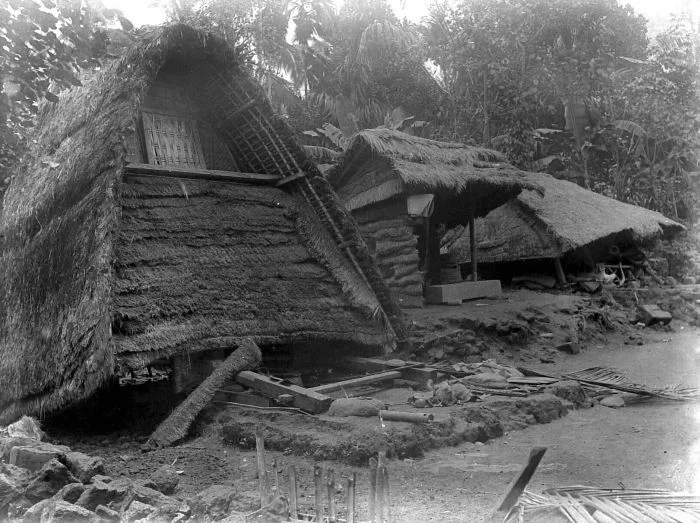
Temples Broken and Rebuilt
The earthquake's toll on Bali's built environment was severe. Across the southern part of the island, temples crumbled. Among the damaged sacred sites was Pura Ulun Danu Batur, one of the most important temples in the Balinese Hindu tradition, dedicated to the goddess of the lake. Stone walls split, tiered meru towers collapsed, and carved gateways fractured along their joints. For the Balinese, the destruction of a temple is not merely an architectural loss -- it is a spiritual disruption, a breach in the relationship between the human world and the divine. Rebuilding was not optional; it was an act of cosmic repair. The temples were restored, as they had been after previous earthquakes and as they would be again. Bali sits on restless ground, and its sacred architecture has always been built with the understanding that the earth will periodically reclaim it. Each reconstruction is both a restoration and a renewal, the same prayers carved into fresh stone.
Living on Restless Ground
The 1917 earthquake was neither the first nor the last major seismic event to strike Bali. The island's geology guarantees a recurring cycle of tremors, and its population density and steep terrain ensure that each one carries consequences. What made 1917 particularly deadly was the combination of strong shaking and vulnerable slopes. The landslides that killed 1,200 of the 1,500 victims were a function of geography as much as geology -- the same fertile volcanic soil that makes Bali's rice terraces so productive also makes its hillsides prone to collapse when saturated and shaken. The Balinese have adapted to this reality over centuries, building their settlements and temples with materials that can be replaced and rituals that account for destruction. The relationship between the island and its people is one of negotiation: the earth provides, and occasionally it takes back.
From the Air
Epicenter located at approximately 8.30S, 115.00E, in the southern part of Bali. The island's volcanic terrain is clearly visible from altitude -- Mount Agung (3,142m) dominates the eastern skyline, with the caldera lake of Mount Batur visible to its west. The southern slopes where the worst landslides occurred are now densely terraced with rice paddies. Nearby airports: Ngurah Rai International Airport (WADD/DPS) on the Bukit Peninsula at Bali's southern tip. The Sunda-Java Trench lies roughly 300km to the south, invisible from the surface but responsible for the tectonic forces that shape the island.
Nearby Stories
- The Rice Goddess and the Dutchmen with Strings 0.4 km away
- Land in the Sea 5.6 km away
- Alas Purwo: Where Java Begins and the Surf Never Stops 18 km away
- When the Ground Moved at Dawn: Bali's 1979 Earthquake 18 km away
- The Tiger's Last Stand: West Bali National Park 25 km away
- Java's Little Africa 39 km away
- Lombok 72 km away
- Forty-Five Men and Thirty-Six Depth Charges 92 km away