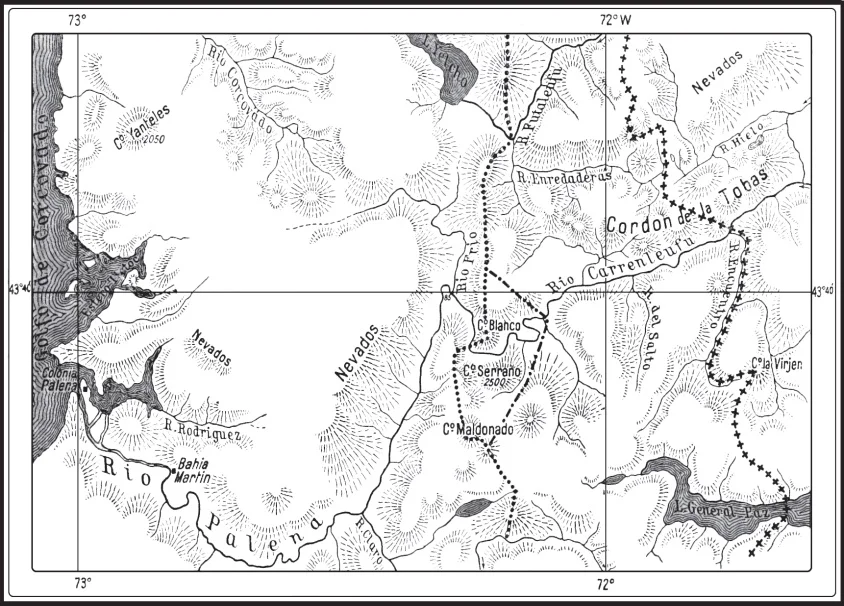

Alto Palena–Encuentro River dispute
It was a surveyor's mistake, and it took more than sixty years and a queen to fix. Somewhere in the dripping mountains of northern Patagonia, where the Andes break into a maze of valleys and rivers, a 1903 demarcator looking for a stream called the Encuentro pointed at the wrong one. He set a boundary marker accordingly. That small error left a handful of fertile valleys in limbo, claimed by both Chile and Argentina, and the families who farmed them spent the next half-century unsure which country they lived in. The dispute ended on December 9, 1966, not with a war but with the arbitral ruling of Queen Elizabeth II of the United Kingdom, who drew the border across land she would never see.
A Line Nobody Could Agree On
Chile and Argentina had tried to fix their long Andean frontier since the 1880s, and the trouble always came down to one question: should the border follow the highest peaks, or the divide between waters flowing to the Atlantic and Pacific? In the rugged south the two lines did not match, and the experts appointed by each country could not reconcile them. When the demarcators deadlocked, the matter went to British arbitration, first under King Edward VII, whose 1902 award split the disputed ground into sections. The following year a British officer, Captain Bertram Dickson, went into the field to place the markers. Near the confluence of the Palena and Encuentro rivers he set landmarks XVI and XVII, but the Encuentro itself was hard to identify, and an earlier surveyor had confused it with a different stream. That confusion would haunt the region for generations.
The People in the Middle
While diplomats argued in distant capitals, settlers were quietly making homes in the contested valleys. The town of Palena was founded by Chileans in 1887, and by 1906 families were populating the California, Hondo, and Horquetas valleys, clearing land and grazing animals in places where the national border existed only as an abstraction on disputed maps. For them the dispute was not theory. In July 1952 the Argentine National Gendarmerie moved into the Hondo and Horquetas valleys and told the settlers there they had one month to register with the Argentine government. In November 1958 the gendarmes returned, surrounding valleys and blocking Chilean families from reaching the winter grazing grounds at the Engaño lakes. Ordinary people raising livestock in a remote frontier kept finding themselves on the wrong side of an argument they had never started.
Fences, Rifles, and a Near-Disaster
Through the late 1950s and early 1960s the tension hardened into incidents. Argentine gendarmes built fences and outposts in the valleys; Chile accused its neighbor of expansionism. In September 1963 a new fence in Valle Hondo triggered a fresh round of protests, though Argentina's President Arturo Illia, in a gesture of goodwill toward Chile, ordered it removed. Not every moment ended so gently. On two occasions the Argentine Gendarmerie fired machine guns toward Chilean Carabineros in the Horquetas valley, and in July 1964 gendarmes shot at, but did not hit, two Chilean journalists. In 1965 a group of gendarmes led by a second lieutenant tried to assault an unarmed Chilean settler in the California valley. The Chilean foreign minister filed a formal protest, and President Illia, once the details reached him, removed the officer responsible. War never came, but it brushed close more than once.
The Queen's Line
Both governments eventually agreed that an outside judge had to settle it. Under earlier treaties they submitted the case to the British Crown, and a Court of Arbitration led by Lord McNair studied the tangled history of the misidentified river. On December 9, 1966, Queen Elizabeth II issued the award. It divided the disputed ground: roughly 420 square kilometers of the more mountainous, unpopulated southern terrain went to Argentina, including the Hondo valley and the Engaño region, while the fertile California valley, long settled by Chileans, was confirmed as Chilean. The ruling accepted Chile's argument that the Encuentro River truly rose in the Cordón de las Vírgenes, correcting at last the old surveyor's error. The demarcation on the ground followed in the summer of 1966 and 1967. A border that two nations had argued over for six decades was finally drawn by a monarch an ocean away, and the families in the valleys at last knew where they lived.
From the Air
The disputed valleys lie along the Chile-Argentina frontier in northern Patagonia at roughly 43.78 degrees south, 71.74 degrees west, near the Chilean town of Palena and General Vintter (Lake General Paz). The nearest Chilean airport is Chaitén Airport (ICAO: SCTN) to the northwest; Balmaceda Airport (ICAO: SCBA) serves the wider Aysén region to the south. From the air the terrain reads as a complex of forested river valleys threading between Andean peaks, with the border weaving along ridgelines and watercourses. The area is wet and frequently cloud-covered; clearest flying conditions come in summer, December through February.
Nearby Stories
- Queulat National Park 51 km away
- Futaleufú River 58 km away
- La Trochita 73 km away
- Chaitén Volcano 87 km away
- Esquel (meteorite) 107 km away
- Pumalín Douglas Tompkins National Park 142 km away
- Hudson Volcano 204 km away
- Lake Colhué Huapi 257 km away