Ambato, Ecuador
On August 5, 1949, the city of Ambato had just finished lunch. By late afternoon, more than five thousand of its residents were dead and the cathedral, the colonial buildings, and most of the downtown had collapsed or were about to. It was the fourth time the city had been leveled by an earthquake. The people who survived rebuilt again. A year later, they established a festival - not to mourn but to celebrate the tenacity that keeps bringing Ambato back. They called it the Festival of Fruits and Flowers, and they scheduled it to coincide with Carnival in February. The disaster had happened in August, but Ambatenos wanted the celebration to feel like a beginning, not an anniversary. That festival is now one of Ecuador's largest, and it marks the same impulse that has always defined this city: the stubbornness to start over, again, in the same valley the earth keeps shaking.
Founded on a Mistake
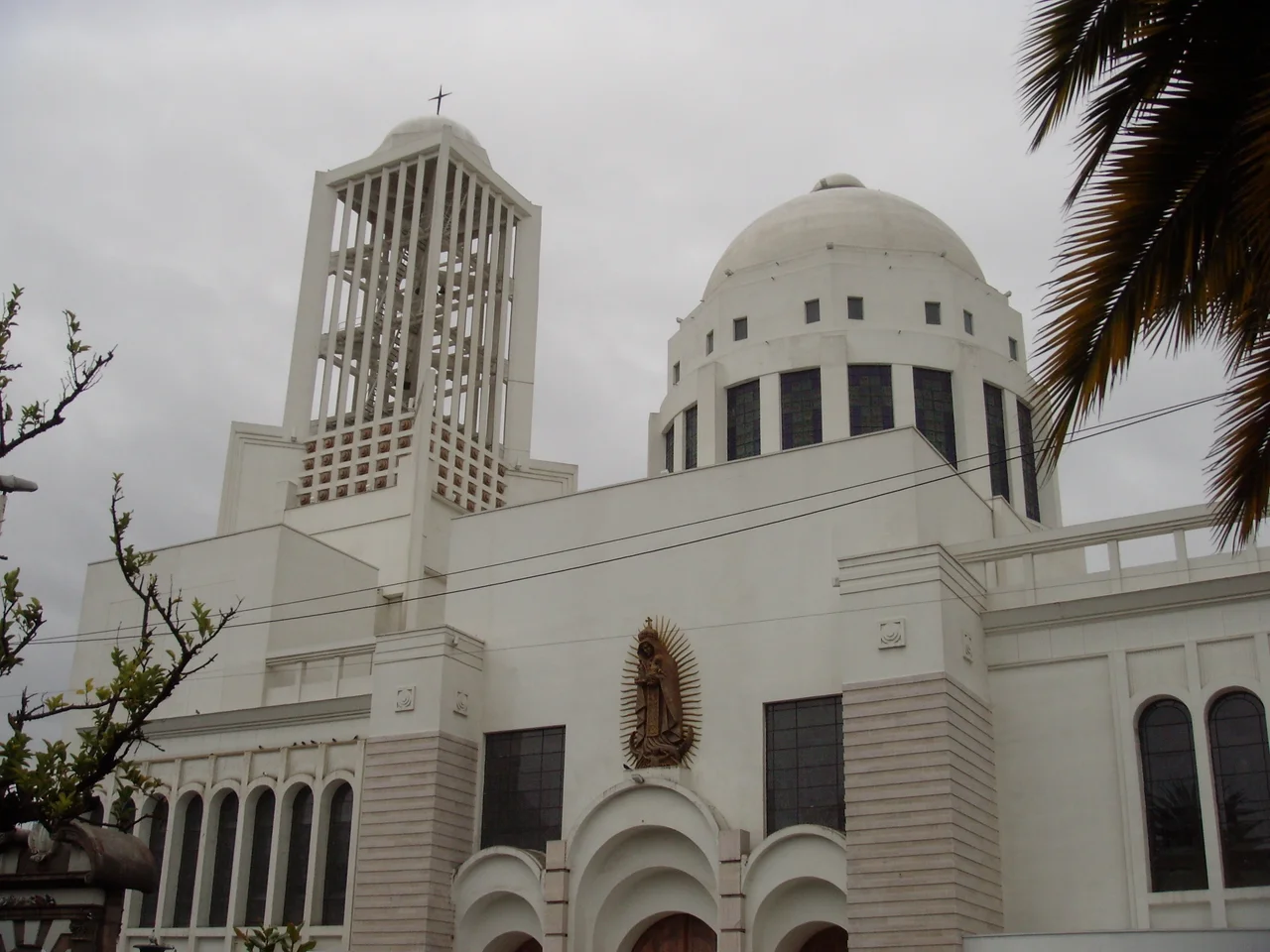
The official founding date is December 6, 1698, but Ambato's relationship with the site is older and more fraught. That June, the earlier Ambato settlement had been destroyed by an earthquake and landslide that killed thousands. The survivors petitioned the Royal Audience of Quito to refound the city on higher ground. They got their wish, but the higher ground turned out to offer only relative safety. The central Andean valley of Ecuador sits where the Nazca Plate is subducting beneath South America at seventy millimeters a year, and the volcanic arc above that subduction zone - Cotopaxi, Tungurahua, Carihuairazo, Chimborazo - forms a ring of active volcanoes visible from the city on clear days. Tungurahua, just forty kilometers to the southeast, erupted as recently as 2006, covering Ambato in a thick layer of ash. The 1797 Riobamba earthquake destroyed the second cathedral. The 1949 earthquake destroyed the third. The current modernist cathedral, inaugurated in 1954, is the fourth attempt on the same spot.
The Three Juans
Ambato's most enduring nickname is La Tierra de los Tres Juanes - the Land of the Three Juans. The title refers to three men born in Ambato in the 19th century who shaped Ecuadorian culture at national scale. Juan Montalvo (1832-1889) was an essayist whose Siete Tratados and Capitulos que se Le Olvidaron a Cervantes made him one of the great Spanish-language prose stylists of his century. Juan Leon Mera (1832-1894), born the same year, wrote the lyrics to Salve, Oh Patria, the Ecuadorian national anthem, and his villa-style house on the Ambato River still stands today as the Quinta Juan Leon Mera, a museum with gardens said to contain 257 species of flowers. Juan Benigno Vela (1843-1920) was a journalist and politician central to the Ecuadorian liberal movement. All three are buried in or around the city they made proud of them, and their names mark streets and schools across the province.
Liberating the Highlands
Ambato played a central role in Ecuadorian independence. On October 9, 1820, Guayaquil declared itself free of Spain. The independence army, the Junta de Guayaquil, marched toward Quito, and Ambato was among the first highland cities to welcome them. On November 12, 1820, Ambato formally declared its own separation from Spain. The liberation did not hold. At the First Battle of Huachi on November 22, 1820, Spanish forces commanded by Colonel Francisco Gonzalez defeated Colonel Luis Urdaneta's patriots just outside Ambato. A year later, in September 1821, Antonio Jose de Sucre tried again at the Second Battle of Huachi and was beaten again on the same plains. Only in 1822, after Sucre marched south to join up with Peruvian forces under Jose de San Martin, did the patriots retake the highlands and defeat the royalists at the Battle of Pichincha. The Huachi neighborhood southeast of downtown Ambato now occupies the plains where two armies of independence died.
Industry in the Mountains
Modern Ambato is an industrial city that does not usually appear on tourist itineraries. At 2,577 meters elevation, surrounded by fertile volcanic soil, the Ambato basin is rich agriculturally, and the city serves as the commercial hub for the Central Cordillera. The local nickname Guaytambos, given to Ambatenos, comes from a variety of peach native to the valley. Ambato's industries include leather tanning, vehicle bodywork (in 2010, Venezuela announced plans for Ambato workshops to refurbish 65 percent of its transport fleet), textiles, glass fabrication, shoes, and foodstuffs. The Monday market is one of the largest in Ecuador, with vendors from across Tungurahua Province filling the streets with textiles, fruit, llapingachos (potato patties with cheese), and colada morada (a purple spiced drink traditionally consumed at Day of the Dead). Macara, Tecnico Universitario, and Mushuc Runa all play professional soccer here, and the Ambato derby between Macara and Tecnico is a fixture of the Ecuadorian calendar.
The Festival of Flowers and the Land of the Three Juans
Every February, the Festival of Fruits and Flowers transforms Ambato's Parque Juan Montalvo and surrounding streets into a cascade of color. The park, designed in 1905 by local architect Pedro Durini, sits in the shadow of the modern cathedral at the meeting of four main streets. A statue of Juan Montalvo, cast in Italy by Pietro Capurro and inaugurated in 1911, anchors the plaza. The festival itself, created in 1950, commemorates the 1949 earthquake by celebrating everything that survived it - the rich volcanic soil, the produce it grows, the people who rebuild. Parades, beauty pageants, bullfights at the 11,000-seat Plaza de Toros Monumental, and cathedral masses fill the week. It is one of the few festivals in the world designed to turn mourning into forward motion, and Ambato has been performing that transformation for roughly every generation of its existence.
From the Air
Ambato, Ecuador sits at approximately 1.24 degrees S, 78.63 degrees W in the central Ecuadorian Andes at 2,577 meters elevation. The city is carved into the side of Cerro Casigana in the main valley of the Central Cordillera. From Ambato, volcanoes Cotopaxi (5,897 m), Tungurahua (5,023 m), Carihuairazo (5,018 m), and Chimborazo (6,263 m) are all visible on clear days. Nearest commercial airport is Mariscal Sucre International (SEQM/UIO) in Quito, 130 km north. Chachoan Airport in Izamba neighborhood is not used for commercial flights. Subtropical highland climate with mild afternoons, cool nights, and occasional volcanic ash from Tungurahua to the southeast.
Nearby Stories
- Riobamba 13 km away
- San Luis de Pambil 18 km away
- La Mana 19 km away
- Puyo, Pastaza 20 km away
- Tena 27 km away
- Laguna Quilotoa 42 km away
- Babahoyo 53 km away
- Borja, Peru 326 km away