Babahoyo
In Babahoyo, the rivers decide where the city can stand. The San Pablo River runs down from the western slopes of the Andes, and the Catarama River meets it in an estuary, and together they form the Babahoyo River, which flows south to join the Daule and become the Guayas, which flows through Guayaquil and out to the Pacific at the Gulf. Babahoyo is one of the last inland points before that system becomes tidal. The city holds about 98,000 people and serves as the capital of Los Ríos province - a lowland province of rice paddies, banana plantations, and agricultural work that feeds the country. It floods almost every winter. It has burned down at least once. And on June 9, 2023, it became the place where Bella Montoya banged on the inside of a coffin lid.
The Woman Who Was Not Dead
Bella Montoya, 76 years old, was admitted to the Martín Icaza government hospital with suspected stroke. She went into what doctors recorded as cardiorespiratory arrest. Resuscitation failed. The attending physician pronounced her dead, and her body was released to her family. A wake began - the traditional Ecuadorian velorio, family gathered for the viewing. Five hours into that wake, neighbors and family members heard knocking from inside the coffin. When they opened the lid, Bella Montoya was breathing heavily and trying to move. A video capturing her in the open coffin spread rapidly through social media. Ecuador's Health Ministry issued a formal statement on June 11. She was returned to the hospital. Cases like this are rare enough worldwide that each becomes a small news event; in Babahoyo, it became one of the stranger dates in local memory. She died a week later, having gone through the experience of being declared dead twice in one lifetime.
Bodegas, Fires, and the Move
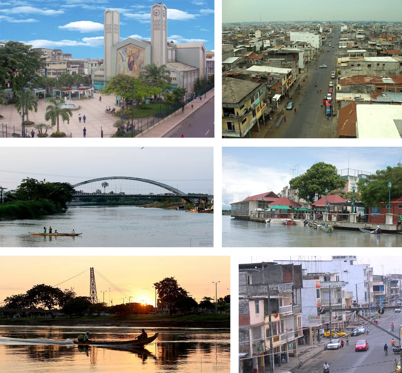
Before Babahoyo was Babahoyo, it was Bodegas - Spanish for warehouses. The customs office and royal stores for the Audiencia de Quito sat here, controlling commerce between Guayaquil and the Ecuadorian mountains. Goods coming up from the coast or down from the highlands passed through Bodegas. Then, on March 30, 1867, fire destroyed much of the town. The losses were severe enough that President Gabriel García Moreno ordered the city moved across the San Pablo River to its current location - the urban district now known as Barreiro. The formal foundation of the new Babahoyo was established on May 27, 1869, on lands ceded by the Flores family. The choice of location - facing the confluence of the Babahoyo and Caracol rivers, on the right bank of the San Pablo - was deliberate: a river town at a point of commercial consequence, relocated to avoid another conflagration but not to escape the water that defines it.
Floods, Bridges, and Buses
Babahoyo floods. Not occasionally, not dramatically, but routinely during Ecuador's rainy winter season. In early 2008, the entire city flooded in a particularly severe event that stretched across months. The infrastructure responds with what infrastructure can. Four vehicle bridges cross the rivers at different points: two spanning the Catarama and San Pablo to the north along the Babahoyo-Quito highway; one crossing the Lagarto marsh to the south on the Babahoyo-Guayaquil highway; one at La Ventura on the Babahoyo-Ambato route. Two pedestrian bridges link Barreiro with El Salto. More than 25,000 vehicles pass through Babahoyo every day because the city sits at a hinge - the place where coastal highway routes cross the great agricultural lowland and reach toward the mountains. Bus companies running between Quito and Guayaquil stop here. Two local cooperatives, Fluminense and Santa Ana, handle the urban routes. Boat service still connects the outer parishes of Pimocha and Caracol to the center.
Rice, Sugar, and the Floating Houses
The surrounding fields produce rice and bananas in the quantities a province called Los Ríos - The Rivers - can reliably deliver. Babahoyo handles the processing and export: rice mills, sugar refineries, balsa wood exports, and the strange commodity called tagua - vegetable ivory, the hard white nut of a palm that was once used worldwide for buttons and chess pieces before plastics arrived. The Ingenio Isabel Maria here is the fourth-largest sugar refinery in Ecuador. Beyond commerce, Babahoyo offers what amounts to a countryside cruise: a boat trip down the Rio Babahoyo, past campesinos tending crops and cattle, past the floating houses that are particular to the area. These houses sit on anchored rafts, rising and falling with the flood waters rather than succumbing to them - a practical adaptation that has become a signature of the region. The city's main dish is ceviche of shrimp, fish, and conch. A more obscure specialty, caldo de manguera, is a hearty sausage soup.
The Virgin of Merced and Parque 24 de Mayo
September 24 is the day of the Virgin of Merced, Babahoyo's patron. Beginning September 15, neighborhood groups carry the Virgin through the streets on nine consecutive nights. On the day itself, the city holds a fair - artisans from the mountain and coastal regions of Ecuador setting up stalls, toys for children, folkloric dancers and singers performing. The cathedral at the heart of the city features an enormous mosaic mural of the Virgin Mary. Parque 24 de Mayo offers the verdant central gardens that every Ecuadorian provincial capital tries to maintain, with mixed success against tropical growth and limited budgets. The Malecón 9 de Octubre anchors the commercial center, where the modern buildings of banks, administrative offices, and shops face the rivers. Babahoyo is not on most tourist itineraries. The city sits at a commercial crossroads, feeds a country, and carries on - which is precisely the kind of place that rewards unhurried attention.
From the Air
Coordinates: 1.82°S, 79.52°W. Elevation near sea level. Recommended viewing altitude: FL180-FL240. Nearest airports: SEGU (Guayaquil - José Joaquín de Olmedo), SEQM (Quito - Mariscal Sucre) for northern approach, SESM (Machala - Santa Rosa). The Babahoyo, San Pablo, and Caracol rivers converge near the city; the confluence is the most visible landmark from altitude, forming the upstream beginning of the Guayas River system. Urban grid visible along the river banks. Expect humid coastal weather; flooding common November-May.
Nearby Stories
- Battle of Yaguachi 7.2 km away
- Pedro Carbo Canton 8.7 km away
- Santiago de Bolivar 20 km away
- Salinas de Guaranda 22 km away
- Ventanas 23 km away
- Alausí Canton 30 km away
- Ecuadorian dry forests 33 km away
- Santa Elena, Ecuador 79 km away