Ecuadorian dry forests
One percent. That is how much of the original Ecuadorian dry forest still stands. Of an ecoregion that once stretched over 2.1 million hectares across the Pacific coast of Ecuador, ninety-nine percent has been cleared for farms, banana plantations, sugar cane, and cattle grazing. What remains is scattered, secondary-growth remnants - small islands of dry forest in a sea of agriculture, home to some of the rarest birds in South America and a flora that nobody will see anywhere else in the world. The World Wildlife Fund classifies this ecoregion as Critical or Endangered. Western Ecuador has one of the greatest risks of biological extinction anywhere on Earth.
A Pacific Dry Forest
Tropical dry forests are an unusual ecosystem anywhere. They occur where the climate is equatorial and warm but rainfall is concentrated in a short wet season, leaving long dry stretches that force plants to adapt in specific ways. The Ecuadorian dry forests cover land sloping from the western foothills of the Andes down to the Pacific Ocean, mainly to the north and west of Guayaquil with a smaller section to the east of the city. The western portion runs along the Cordillera de la Costa - a coastal range that collects enough moisture from the Pacific to support the forest but not enough to sustain true rainforest. The Koppen climate classification calls it Aw: equatorial, dry winter. Average monthly temperatures hover around 25.5 degrees Celsius year-round. The dry periods are long; the wet periods are intense; the plants and animals here have spent millennia calibrating their survival to this specific rhythm.
A Biodiversity Hotspot
The ecoregion sits inside the Tumbes-Choco-Magdalena biodiversity hotspot - one of only twenty-five regions globally identified as holding significant biodiversity under critical threat. It is also part of a larger 103,000-square-kilometer ecoregion called the Tumbesian-Andean Valleys Dry Forests, which encompasses six terrestrial ecoregions stretching from northern Peru through Ecuador and into Colombia: the Tumbes-Piura dry forests, the Ecuadorian dry forests, the Patia Valley dry forests, the Magdalena Valley dry forests, the Cauca Valley dry forests, and the Maranon dry forests. Twenty percent of the plant species here are endemic - found nowhere else. About thirty percent of the bird species in the Tumbes Region of coastal Ecuador and Peru, or seventy-seven species, are endemic to this forest system. Twenty-two of them are at risk of global extinction. The numbers add up to an ecosystem that exists in a quiet emergency.
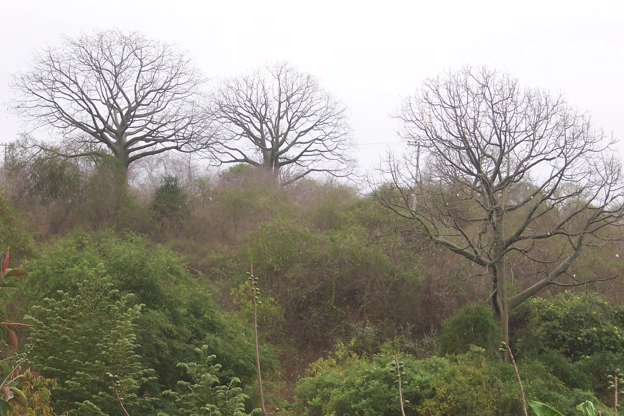
The Tree That Rots
One tree in the Ecuadorian dry forest survives by cheating. The Ceiba trichastandra, a kapok species, has evolved green bark that photosynthesizes directly - meaning the tree can keep making food during the dry season when it has shed all its leaves to conserve water. The strategy lets it grow higher than surrounding trees, emerging from the forest canopy. It also produces wood that rots easily, which turns out to be a quiet advantage: loggers have generally spared Ceiba trichastandra because the wood is not worth much, and the tree has survived deforestation better than its harder-wooded neighbors. Other dry forest species grow thorns on their trunks when young - protection against animals that would strip their bark for water - and shed the thorns as they mature. Leaves carry waxy coatings to reduce evaporation. Some plants close their leaves at night. Roots thicken into water-storage organs. The whole forest has become a study in how to live on very little moisture for most of the year.
The Birds That Vanished Elsewhere
Birders travel to the Ecuadorian dry forests specifically for species they cannot see anywhere else. The list includes the great green macaw (Ara ambiguus), the grey-cheeked parakeet (Brotogeris pyrrhoptera), the Esmeraldas woodstar (Chaetocercus berlepschi) - a hummingbird endemic to the coast of Ecuador - the grey-backed hawk (Pseudastur occidentalis), the slaty becard (Pachyramphus spodiurus), and the blackish-headed spinetail (Synallaxis tithys). The El Oro parakeet (Pyrrhura orcesi) and El Oro tapaculo (Scytalopus robbinsi) are named for the Ecuadorian province where they live. In the bamboo thickets of the southwest, three species cling to existence in the critically endangered category: the pale-headed brush finch, the black-eared hemispingus, and the grey-headed antbird. The forest also serves as a resting ground for migrant birds passing through, and as a seasonal fruit source for species that descend from the adjacent montane forests when their own food runs thin. The mammals still hang on: jaguars, ocelots, mantled howler monkeys, white-tailed deer, and agoutis move through what is left.
Ninety-Nine Percent Lost
The destruction of the Ecuadorian dry forest is one of the most dramatic habitat losses in the Americas. Ninety-nine percent of the original dry forest has been cleared - primarily for agriculture, with selective logging of the most valuable species and slash-and-burn clearance for crops and cattle. Overgrazing and planting on unstable hillsides have caused severe erosion in what remains. The forest fragments that survive are isolated from one another, unable to support the large mammal and bird populations that a connected forest once maintained. Conservation efforts have designated several protected areas: Machalilla National Park on the coast of Manabi, the Cerro Blanco Protective Forest near Guayaquil, the Molleturo Protective Forest in the Azuay highlands, and the Arenillas Military Reserve along the Peruvian border. The privately owned two-hundred-hectare Lalo Loor Dry Forest Reserve, in transitional terrain between the very wet northern forests and the very dry southern ones, protects an unusually diverse flora and has been developed for ecotourism. But the existing conservation is not enough. The fragments need corridors connecting them, and new protected areas need to be established.
Machalilla
If the Ecuadorian dry forest has a flagship park, it is Machalilla National Park on the coast of Manabi Province. The park protects remnants of both dry and moist forests and catalogs an extraordinary richness within its bounds: 234 bird species recorded, 81 mammal species, and the fraternal fruit-eating bat (Artibeus fraterculus) endemic to this corner of Ecuador. The park also includes Isla de la Plata, the small offshore island sometimes called the Poor Man's Galapagos for its blue-footed booby and frigatebird colonies. Machalilla serves as the primary destination for travelers who want to see what the Ecuadorian dry forest looked like before most of it disappeared. The park has flaws - limited funding, isolated patches, the same pressures of surrounding agriculture that have reduced the rest of the ecoregion - but it preserves enough intact forest that a visitor can walk under Ceiba trichastandra canopies, hear grey-cheeked parakeets calling, and see what most of western Ecuador used to be.
From the Air
Ecuadorian dry forests centered near 1.35 S, 80.33 W, stretching along Ecuador's Pacific coast mainly north and west of Guayaquil. Visible from altitude as drier vegetation zones distinct from surrounding banana plantations and moist forests. Machalilla National Park on the Manabi coast the largest intact section. Nearest airports: Guayaquil Jose Joaquin de Olmedo (SEGU), Manta Eloy Alfaro International (SEMT). Recommended viewing altitude 5,000-8,000 feet for ecosystem context. Clear skies typical during dry season June through November; January through May brings afternoon showers.
Nearby Stories
- Portoviejo 14 km away
- Pedro Carbo 28 km away
- Guayas Province 35 km away
- Western Ecuador Moist Forests 36 km away
- Ventanas 40 km away
- Salinas (Ecuador) 100 km away
- Malpelo Plate 479 km away