Western Ecuador Moist Forests
Pull a single hectare of this forest apart and you'll find 1,250 species of plants growing in 136 families. Walk a different hectare a few kilometers away and the cast of characters changes. The narrow strip of forest pinned between the Pacific Ocean and the western slope of the Andes evolved in such isolation, broken into so many ecological islands by ridges and valleys, that new orchid species are still being named here. A 1990 survey identified 122 of them at once. The catch: most of the forest that produced this explosion of life is already gone.
A Forest Between Two Walls
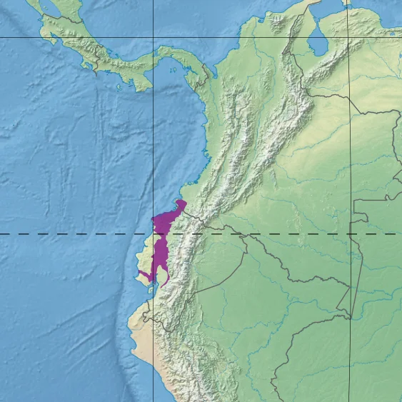
The Western Ecuador moist forests stretch from southern Colombia down through the provinces of Esmeraldas, Manabí, and Guayas, ending at the Gulf of Guayaquil. To the east rises the Andean wall. To the west, the Pacific. The strip in between covers about 34,108 square kilometers of coastal plain and foothills, climbing from sea level up to roughly 800 meters before montane forests take over. In the north, more than 7,000 millimeters of rain can fall in a single year, with some places exceeding 8,000. The southern reaches are drier but never truly dry. Volcanic ash and lapilli from old eruptions have made the soils unusually fertile, which is part of the problem: anything that grows trees this well also grows bananas, oil palm, and rubber.
Endemism Run Wild
Around 10,000 species of plants have been recorded in the ecoregion, and roughly a quarter of them live nowhere else on Earth. The canopy rises above 30 meters, with emergent strangler figs like Ficus dugandii pushing past 60. Brosimum, Carapa, and Virola dominate the upper story. Beneath them, the understory is a tangle of palms, ferns, mosses, lichens, and epiphytes from the Araceae and Cyclanthaceae families clinging to lower trunks. Natural fragmentation by ridges and rivers has acted like an evolution machine, isolating populations long enough for them to diverge into something new. The endemic tree Humiriastrum procerum, prized by loggers for construction, grows only north of the Guayllabamba River. Botanists keep finding plants here that have never been described.
The Birds Most People Will Never See
A 1993 survey identified 650 bird species in the ecoregion, and the names read like a catalog of things on the edge of disappearing. The long-wattled umbrellabird, with its absurd bib of feathers dangling from its throat. The El Oro parakeet and El Oro tapaculo, both restricted to a few patches of cloud-forest fringe. The banded ground cuckoo, the Esmeraldas woodstar, the great green macaw. Hunting and habitat loss have nearly erased the great curassow, the great tinamou, and the harpy eagle from the western lowlands. The amphibians fare no better. Phantasmal poison frogs, horned marsupial frogs, and a half-dozen Pristimantis species cling to fragments of forest while their wider world is cleared around them.
Critical and Endangered
The World Wide Fund for Nature classifies the ecoregion as Critical/Endangered. Most of the destruction happened fast, between roughly 1960 and 1980, when highways pushed in and oil exploration opened up the lowlands. What followed was a wave of plantation agriculture that has not slowed. Banana, palm oil, and rubber operations continue to convert remnant forest. The largest surviving block sits in Esmeraldas province, between the San Lorenzo Canton near the Colombian border and Quinindé. Elsewhere, the original forest survives only in narrow strips along the mountains, often degraded near the edges by settlements and unregulated logging. Protection exists in the Cotacachi-Cayapas Ecological Reserve and in the highland portions of Machalilla National Park. The Río Palenque Scientific Station, a tiny enclave in Esmeraldas, has documented species the rest of the region has already lost.
What Endemism Looks Like From Above
From the air, the ecoregion reads as a quilt: green ridges of remnant forest interrupted by the geometric blocks of plantations, then more green, then a road, then more blocks. The mountains in the east stay forested longer because they are harder to reach. Near the coast, the mosaic is finer and the forest fragments smaller. Each surviving patch may hold species found nowhere else, sometimes restricted to a single ridge. Conservation biologists call this kind of distribution irreplaceable, meaning that if a particular ridge burns or is cleared, the species disappear globally. The Western Ecuador moist forests are a textbook case of the math working against itself: extreme endemism plus extreme habitat loss equals an extinction rate the rest of the world has barely noticed.
From the Air
Located at 0.89°S, 79.52°W along Ecuador's Pacific coast. From cruising altitude, the ecoregion appears as a green strip pressed between the white-capped Andes to the east and the Pacific to the west, broken by the agricultural blocks of banana and palm-oil plantations. Nearest major airports include Mariscal Sucre International (SEQM) at Quito and José Joaquín de Olmedo International (SEGU) at Guayaquil. Best viewing 5,000 to 15,000 feet AGL; cloud cover is heavy year-round, with the clearest skies typically July through September.
Nearby Stories
- Andean Highlands (Ecuador) 12 km away
- Salinas de Guaranda 22 km away
- Ecuadorian dry forests 24 km away
- Manabí Mangroves 25 km away
- Ventanas 30 km away
- Portoviejo 35 km away
- Illiniza 43 km away
- Jama-Coaque Ecological Reserve 86 km away