Andean Highlands (Ecuador)
Alexander von Humboldt, climbing through Ecuador in 1802, looked at the central plateau running north to south between the country's two Andean ranges and called it the Avenue of the Volcanoes. The name stuck. More than two centuries later, the Pan-American Highway - signed as E35 within Ecuador - runs the length of that same corridor, connecting Quito in the north to Loja in the south, threading past Cotopaxi and Chimborazo and Tungurahua. This is the Andean Highlands: a region starting at roughly 2,200 meters and climbing to Ecuador's highest peak, Chimborazo at 6,263 meters, where pre-Columbian heritage persists in food, language, clothing, and a thousand small daily practices that the country's coastal cities have partly abandoned.
Two Ranges, One Valley
The Ecuadorian Andes are not a single ridge but two parallel ranges: the Cordillera Occidental to the west and the Cordillera Central to the east. Between them lies the fertile central plateau where most highland cities are built - Quito, Latacunga, Ambato, Riobamba, Cuenca, Loja. Both ranges carry volcanoes, many of them still active, and their peaks are prime targets for mountain climbers who come from every continent. Chimborazo, the tallest, reaches 6,263 meters - not the tallest mountain above sea level on Earth, but because of the equatorial bulge, its summit is actually the point on the planet's surface furthest from the planet's center. Mount Everest is higher above sea level; Chimborazo is further from the core. For mountaineers who collect superlatives, this is the one to pocket.
A Land Measured in Elevations
Temperature in the Andean Highlands depends more on altitude than on latitude, which sits almost on the equator here. The lowlands of the Littoral provinces start warm and humid, subtropical. Climb through the foothills and the vegetation shifts every few hundred meters. By 3,000 meters you are in cool, often-misty cloud forest. Above 3,500, you reach páramo - alpine tundra, the particular Andean high-altitude grassland that holds rare plants like the frailejón and stores water the way coastal reservoirs do further south. Above 4,800 meters, bare rock and glaciers. Altitude sickness is real and affects visitors who push their first days too hard; taking it slow the first 48 hours is the standard advice, along with coca tea where available and plenty of water regardless.
The Provinces of the Plateau
The highlands divide into ten provinces. Azuay holds Cuenca, the third-largest city in Ecuador and a colonial architectural jewel with UNESCO status. Bolivar centers on Guaranda, called the Rome of Ecuador because it sits on seven hills; Salinas de Guaranda, a village nearby, produces the country's premier cheeses under the Salinerito brand through a community cooperative started in the 1970s. Chimborazo Province contains Riobamba, the starting point for climbs of Chimborazo itself, plus the town of Alausí where the Devil's Nose train descends a vertical mountain. Cotopaxi holds Latacunga, gateway to Cotopaxi National Park. Imbabura, close to the Colombian border, includes Otavalo, whose weekly market is world-famous for textiles and handicrafts. Loja, in the south, is the jumping-off point for Vilcabamba - a long green valley famous for its unusually old residents. Pichincha holds the capital Quito. Cañar to the south of Chimborazo, Tungurahua with Ambato and Baños, and Carchi with its border crossings round out the list.
Quichua, Llapingachos, and the Things That Stay
Spanish is nearly universal in Ecuador, but across the highlands - especially in Chimborazo and Tungurahua provinces, and in rural communities everywhere - Quichua remains the first language of many. Any attempt to use a few words of Quichua is received with genuine warmth. Foods reflect the same mixing: llapingachos (seared potato cakes with cheese), empanadas, sancocho (a soup of sheep or pork with root vegetables and corn), and guaguatanda (sweet bread shaped like swaddled babies, baked for the November 2 Day of the Dead). The Salinas cheese from Guaranda reaches nearly every highland market. Cuy - roasted guinea pig - is still the celebration food in many Indigenous communities, prepared for festivals and family gatherings. It is the kind of cuisine that rewards curiosity and punishes hurry.
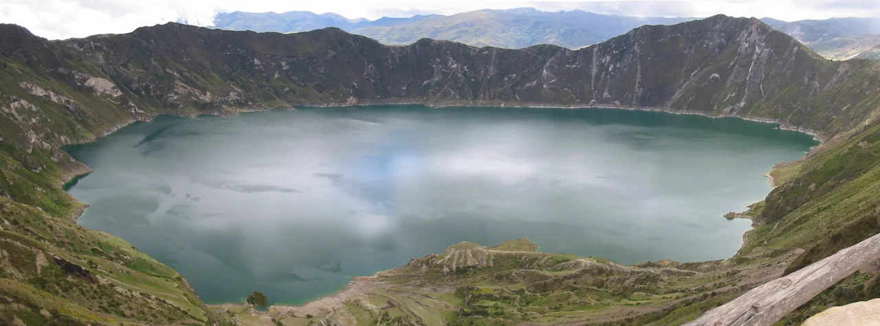
The Things to Do, The Places to Pause
The highlands offer what mountain regions everywhere offer - hiking, biking, climbing, horseback riding - and a few things that are particular to Ecuador. Birdwatching in the cloud forests around Mindo draws specialists from around the world; over 400 species have been recorded within a few kilometers of the town. Rafting in Baños, on the Pastaza River, provides Class III-IV water in an Amazon-facing gorge where the mountains open toward the jungle. The Quilotoa Loop - a multi-day hike through Saquisilí, Laguna Quilotoa, and Isinliví - remains one of Ecuador's most satisfying walking itineraries, crossing high passes and dropping into Indigenous farming villages that welcome travelers on foot. And always: the colonial towns, still carrying the grid plans the Spanish laid down on Inca foundations, where mornings start cold and end bright and the afternoons bring fast-moving weather. Buses connect almost everywhere. For longer hops - Quito to Cuenca, Quito to Loja - Ecuadorian domestic airlines offer faster transitions, landing in the thin air where the runways are already a kilometer higher than the pilots are used to.
From the Air
Coordinates: 1.00°S, 79.00°W (approximate regional center). The Andean Highlands span roughly from 1°N to 5°S along the Ecuadorian spine. Elevations 2,200-6,263m. Recommended viewing altitude: FL300-FL380 for the full range of volcanoes. Major airports: SEQM (Quito - Mariscal Sucre), SELT (Cuenca - Mariscal Lamar), SELO (Loja - Catamayo/Camilo Ponce Enríquez), SERB (Riobamba), Santa Rosa (SESM) for coastal transitions. Chimborazo (6,263m), Cotopaxi (5,897m), and Cayambe (5,790m) are the most visible peaks. Morning flights offer the clearest views before afternoon convective clouds build up over the plateau.
Nearby Stories
- Buena Fe Canton 8.6 km away
- Salinas de Guaranda 22 km away
- Pailón del Diablo 22 km away
- Illiniza 24 km away
- Ventanas 25 km away
- Llanganates National Park 26 km away
- Tababela 59 km away
- 1942 Ecuador earthquake 98 km away