Pailón del Diablo
Angel Lascano got himself excommunicated over the name of a waterfall. In the 1940s, this local from the tiny Ecuadorian town of Río Verde decided that the violent, churning cataract at the edge of town looked exactly like what it was - a cauldron boiling with devils. The Río Verde river thundered 80 meters into a basin of rock so contorted and wrathful that the spray itself seemed to hiss. Lascano insisted the place be called Pailón del Diablo, the Devil's Cauldron. The parish priest disagreed strenuously. Diablo, he said, had no place in a Catholic town's vocabulary. Excommunication followed. The name remained. Today, with San Rafael Falls collapsed into its own sinkhole in 2020, this cauldron claims the title of Ecuador's largest active waterfall.
A Cauldron Shaped by Water
The Río Verde does not fall politely. It arrives at the lip of a narrow gorge in the Tungurahua Province foothills, then drops into a sculpted basin of volcanic rock where every surface works against the water's escape. The result is a 260-foot descent compressed into a shape that refuses to let the river simply plunge and run. Instead the water circles, slams, boils back on itself, and finally - after shedding its fury - slides into the Pastaza River just downstream. The Pastaza carries the mingled flow eastward, eventually feeding the Amazon some two thousand miles away. The basin's rock formations are the reason for the name: viewed from certain angles, the dark, fractured stone suggests the horned face old-timers claimed to see. Whether or not you see the devil, you understand the cauldron.
The Local Who Named It
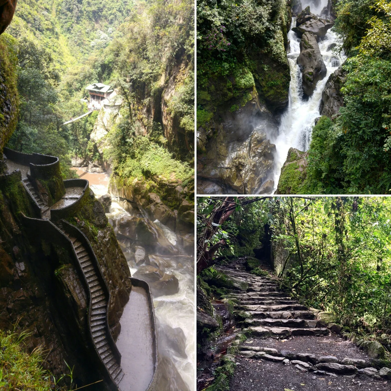
For most of the twentieth century, Pailón del Diablo belonged only to the people of Río Verde. Roads were poor. Outside visitors were rare. The Baños de Agua Santa municipality eventually funded a suspension bridge across the Pastaza at the mouth of the falls, which was primarily meant to help farmers get produce to market but also, almost as a bonus, granted the first structured glimpse of the cataract to anyone willing to cross it. Access remained difficult. Then in the 1990s, two men changed that. Wilo Guevara bought land from his father-in-law on the Puyo side and opened what he called Pailón Grieta al Cielo, the Crack to the Sky - a long route leading alongside the falls, through dramatic stairways carved into cliff face. Around the same time Donald Wolfram, a Quiteño, bought the Baños side and opened a shorter route offering the full frontal view.
Two Approaches, One Cataract
The short route, now called Cascada El Pailón, is approximately four times shorter than the long route and features what most photographs capture: two asymmetrical double suspension bridges offering the complete 80-meter panorama. TripAdvisor has repeatedly given it the Traveler's Choice award for the region. Along the way, visitors pass glimpses of the smaller San Miguel Waterfall - named, according to local tradition, for the archangel Michael who is believed to watch over the Devil in the cauldron and ensure he stays trapped below. Between the two waterfalls sits the Encañada del Duende, a hidden emerald lagoon tucked into tropical vegetation. The long route, meanwhile, hugs the lower side of the falls. It offers no full frontal view but something arguably more visceral: the experience of approaching the cataract from beneath, through staircases pressed against the rock, close enough to feel the spray deform the air.
A Name That Refuses to Go Quietly
In recent years, misinformation has circulated claiming the waterfall was historically called Cascada Río Verde. A CNN Español video and a National Geographic article both repeated the claim, apparently misreading a local song. The song in question actually refers to a different cataract, Cascada Río Blanco. Ecuador officially recognizes the traditional name - the one Angel Lascano defended to the point of spiritual exile - and national tourism campaigns use it consistently. In 2021, the bucket-list guide World's Most Amazing Places included Pailón del Diablo among its top 100 destinations. LATAM Airlines featured it in a promotional video showcasing Ecuador's natural beauty. The excommunicated man's insistence won out. The devil stayed in the name.
From the Air
Located at 1.40°S, 78.30°W in the Tungurahua Province foothills of central Ecuador, along the Río Verde and Pastaza River corridor that descends from the Andes toward the Amazon basin. Elevation around 1,700m. Viewing altitude 4,000-5,000m reveals the narrow gorge cutting through dense cloud forest between Baños de Agua Santa to the west and Puyo to the east. Nearest airport: Río Amazonas (SESM) at Shell, ~25nm east, mainly handling light aircraft. Tena Airport (SETE) further north. The Pastaza River's deep green gorge is the primary visual reference; Tungurahua volcano (5,023m) rises prominently to the northwest. Weather often overcast - this corridor sits in the humid transition zone between Andes and Amazon.
Nearby Stories
- Chimborazo 18 km away
- Laguna Quilotoa 27 km away
- Guaranda 28 km away
- Sangay National Park 31 km away
- Tena 46 km away
- Sumaco Napo-Galeras National Park 76 km away
- Ecuadorian Amazon 106 km away
- Napo moist forests 321 km away