Amhara Region
The water that feeds Egypt begins here. At Bahir Dar, on the southern shore of Lake Tana, the Blue Nile spills out of Ethiopia's largest inland lake and starts its long journey north. During the summer rains from June to September, this single river supplies about two-thirds of the water that reaches the Nile proper. For thousands of years, until the Aswan High Dam was completed in 1970, the silt carried downstream by these floods fertilized the Nile Valley and underwrote the rise of ancient Egypt. The region that produces all this water calls itself Amhara, a name that means noble or highland, and it is, by almost every measure, the heartland of Ethiopia - the place where emperors were crowned, where the Ethiopian Orthodox Church consolidated, and where the country still guards more UNESCO World Heritage Sites than any other region.
The Roof of Africa
Eighty percent of Ethiopia's annual rainfall lands on the Amhara highlands, which is why the region is also the country's breadbasket. The Semien Mountains, declared one of the first natural World Heritage Sites in 1978, hold the country's three tallest peaks: Ras Dashen at 4,543 meters, Kidis Yared at 4,453 meters, and Mount Bwahit at 4,437 meters. These are high enough to support ecosystems that evolved in isolation. The walia ibex lives nowhere else on earth. The gelada, sometimes called a bleeding-heart baboon for the hourglass patch of bare red skin on its chest, grazes in troops of hundreds across the alpine grasslands. The Ethiopian wolf - the rarest canid in the world - hunts giant mole-rats along the ridges. The topography does the work of continents here: altitude creates islands in the sky.
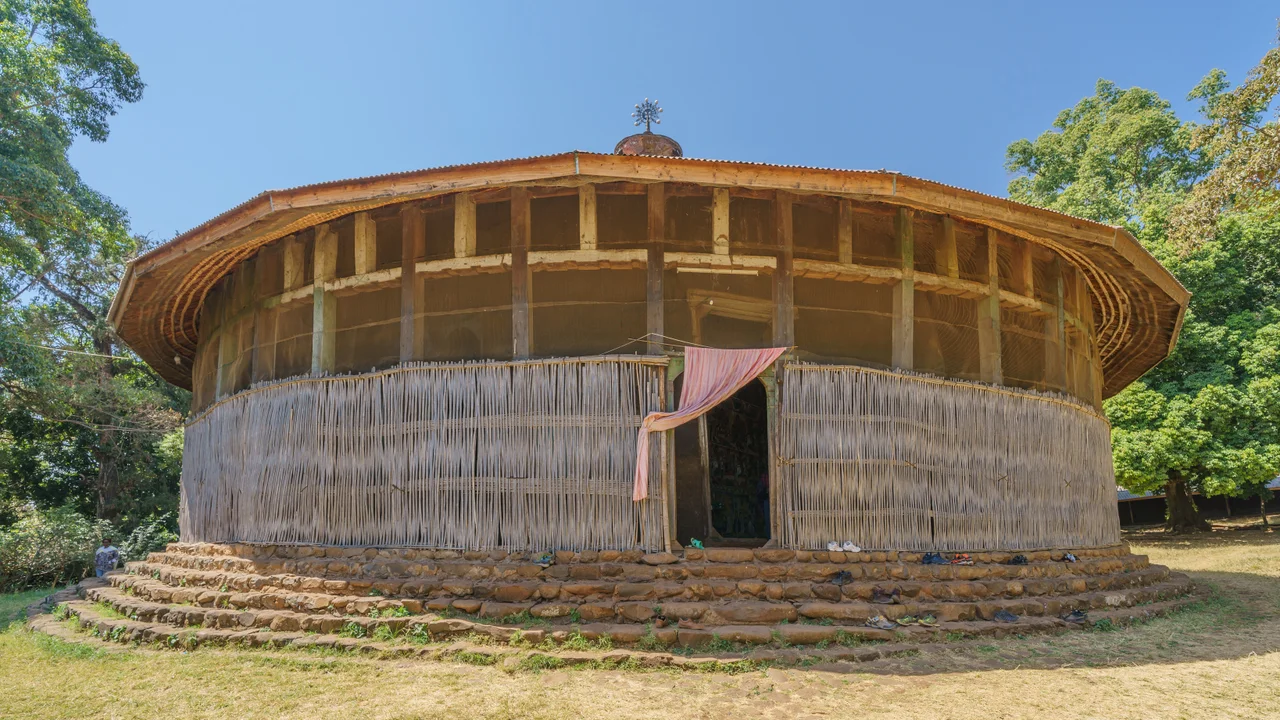
Lake Tana's Monasteries
Scattered across Lake Tana are islands, roughly thirty-seven of them depending on water levels, and on many of them stand monasteries that have guarded Ethiopian Orthodox treasures for a thousand years. The body of Emperor Yekuno Amlak, founder of the Solomonic Dynasty in 1270, is interred at the monastery of Saint Stephen on Daga Island. So are the tombs of emperors Dawit I, Zara Yaqob, Za Dengel, and Fasilides. When the Portuguese missionary Manoel de Almeida reported on the lake in the early seventeenth century, he counted twenty-one islands and noted that seven or eight had monasteries. On the island of Tana Qirqos, a rock is shown to visitors that tradition says the Virgin Mary rested upon during her journey back from Egypt. Saint Frumentius, who brought Christianity to Ethiopia in the fourth century, is said to be buried there. Whether or not you believe any of it, the atmosphere is old.
Gondar, The Camelot of Africa
From 1636 to 1864, the imperial capital was Gondar, and a walled royal compound called Fasil Ghebbi stood at its center. The enclosure contains around twenty palaces, churches, a library, a banqueting hall, stables for the horses of emperors, and a chancellery. Travelers in the nineteenth century called it the Camelot of Africa, which was not entirely fair to Gondar - the architecture mixes Portuguese, Indian, and local Ethiopian traditions in ways that produce something genuinely its own. UNESCO added Fasil Ghebbi to its list in 1979. Walk the ruins today and you are walking where Emperor Fasilides, who founded the city in 1636, presided over the consolidation of an imperial Ethiopian state that had been roving between temporary capitals for centuries.
A Population and a Conflict
About 32 million people live in the Amhara Region as of 2022 projections. About 91 percent speak Amharic as their first language; the rest belong to Agaw, Awi, Oromo, Beta Israel, Qemant, Argobba, and Gumuz communities. Ninety percent of Amharans are rural, farming barley, teff, corn, wheat, and sorghum in terraced fields that step up the highland slopes. The region has been in crisis for several years. In June 2019, a regional coup attempt ended with the assassination of the regional president Ambachew Mekonnen and the Ethiopian Chief of the General Staff Se'are Mekonnen. In 2023 a wider conflict erupted between the federal army and the Fano militia, and since August of that year the War in Amhara has displaced civilians, damaged towns, and drawn reports of extrajudicial killings from the Ethiopian Human Rights Commission. The highlands that fed the Nile are now a conflict zone, and the tourism that once sustained Gondar and Bahir Dar has largely collapsed.
The Lalibela Connection
Drive a few hours from the Amhara provincial capital and you reach Lalibela, where eleven churches were carved down into the bedrock in the twelfth and thirteenth centuries under the Zagwe dynasty. Then a Solomonic noble named Yekuno Amlak rose out of Bete Amhara, around Lake Hayk, and restored the Solomonic line in 1270. The transition from Zagwe to Solomonic was not a break but a handoff: the Zagwe kings had preserved the Aksumite Christian inheritance, and the Solomonic emperors who followed propagated it through Gojjam, Begemder, and northern Shewa. Everything in Ethiopian history runs through these highlands, the noble highland - which is, after all, what the word Amhara means.
From the Air
The Amhara Region centers around 11.66 N, 37.96 E in northern Ethiopia. Bahir Dar Airport (HABD) sits at 1,840 m on Lake Tana's southern shore; Gondar Atse Tewodros (HAGN) is 130 km north. The Semien Mountains demand respect - Ras Dashen at 4,543 m means cruise altitudes of 17,000+ feet for clearance, and mountain wave turbulence is common. Lake Tana is unmistakable from altitude: a 3,000 square km body of water feeding the Blue Nile south from Bahir Dar. Active conflict zones currently affect overland travel in much of the region.
Nearby Stories
- Lake Tana 5.5 km away
- Fasilides 25 km away
- Lalibela 80 km away
- Battle of Culqualber 80 km away
- Western Zone, Tigray 231 km away
- National Museum of Ethiopia 270 km away
- Gimbi Massacre 292 km away