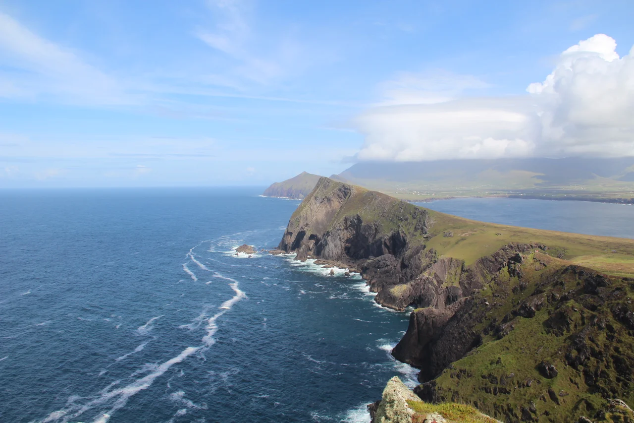

An Triúr Deirféar
On the northwestern shoulder of the Dingle Peninsula, three hills line up against the Atlantic like a row of standing stones. Their Irish name is An Triur Deirfear - The Three Sisters - and at sunset, when the sea silvers behind them and the green of the slopes goes purple, the family resemblance is unmistakable. Look at any tourist photograph of Smerwick Harbour and the Three Sisters are the silhouettes on the western horizon. Look at any map of Corca Dhuibhne, the Kerry Gaeltacht, and they are the lacy fringe at the peninsula's edge. They are not the highest hills in the area. They are not even particularly difficult to climb. What they have, and what has kept their name in local mouths for centuries, is shape.
Three Brothers Named Sisters
There is a small irregularity in the naming that even Irish-language scholars have noted with amusement: although the peaks are called the Three Sisters, the individual hills carry distinctly masculine names. Binn Hanrai - sometimes anglicised as Henry's Peak - sits on the western end. Binn Meanach - the middle peak - holds the centre. Binn Diarmada - Dermot's Peak - rises on the eastern end to an elevation of 153 metres, the highest of the three. None of these names is female. Where, then, do the sisters come from? Possibly from an older folk tradition since lost. Possibly from the visual fact that the three hills, like three women standing in a row, share posture and stature in a way that masculine outlines rarely do. The Irish language is full of such gendered landscapes, and the Three Sisters are among the more contradictory.
The Geography of the Edge
The peaks sit just north of the village of Baile an Fheirtearaigh - Ballyferriter in English - one of the heartland villages of the West Kerry Gaeltacht. To the south rises Mount Brandon, the second-highest peak in Ireland and a major pilgrimage site associated with Saint Brendan the Navigator. To the west, beyond the Three Sisters' cliffs, lie the Blasket Islands - Inishtooskert with its Sleeping Giant profile, Tearaght with its lighthouse, and the rest of the small archipelago - visible on any clear day. To the east stretches Smerwick Harbour, called Ard na Caithne in Irish, a bay with a violent sixteenth-century history. The Three Sisters mark the boundary between the working farmland of Ballyferriter and the open Atlantic. They are not crossed; they are walked along.
Walking the Ridge
The walk along the Three Sisters is one of the modest pleasures of Kerry hiking. You start near Sybil Point - Pointe an tSiabhail in Irish - and follow a grassy ridgeline that rises gently across the three peaks before falling away above the cliffs. Underfoot is short-cropped sheep grass, sea-pink, and stone outcrops weathered into rounded shapes. To the south you can see the long arc of Smerwick Harbour and, beyond it, the rougher mass of Mount Brandon. To the north and west the cliffs drop suddenly to the Atlantic, and on a clear day you can pick out the individual Blaskets. The total elevation gain is modest. The walk takes a few hours. The reward is one of the best views in Ireland of a coastline that has been called - with only modest exaggeration - the most beautiful in Europe.
Seen from Brandon
There is a classic photograph, taken from the upper slopes of Mount Brandon looking west, in which the entire northwestern tip of the Dingle Peninsula is laid out like a relief map. The Three Sisters occupy the middle distance, three small bumps against the blue of the harbour. The Blaskets sit on the horizon beyond. The pattern of fields and stone walls reaches down to the headlands. It is a view that contains, in a single frame, the geological history of the peninsula and the human history of the Gaeltacht. Brandon Mountain is sacred. The harbour was a landing for Spanish and Italian troops in 1580. The villages still speak Irish. And the Three Sisters, modest and oddly named, give the coastline its visual rhythm - the three pulses before the open sea begins.
Why a Hill Has a Name
A hill 153 metres tall does not, in most parts of the world, need a name. It is not high enough to obstruct anything important. It is not isolated enough to function as a sea-mark. But in a small landscape, every feature matters. The Three Sisters are named because they are visible from the villages below; because they shape the angle of the wind off the Atlantic; because they have been walked, grazed, and seen from the same kitchen windows for a thousand years. The naming is itself a form of belonging. To live in Baile an Fheirtearaigh is to know that Binn Hanrai catches the last evening light, that Binn Meanach holds the snow longest in winter, that Binn Diarmada is the one you climb when you want to look out at the Blaskets. The peaks do not call themselves sisters. The people who live below them do.
From the Air
Located at 52.20 degrees north, 10.42 degrees west, at the northwestern tip of the Dingle Peninsula in County Kerry. The three peaks line up roughly east-to-west along the coast just north of Ballyferriter village. Highest summit (Binn Diarmada) is 153 metres. Kerry Airport (EIKY) lies about 30 nautical miles east-northeast. Recommended observation altitude 2,000 to 3,500 feet AGL in clear weather for the classic three-summit profile. Approaches from the south offer the best view of the ridge against the open Atlantic. Be aware of mountain wave turbulence in strong westerlies and cloud lowering rapidly from the Atlantic.
Nearby Stories
- Ballyheigue Castle 1 km away
- Killemlagh Church 2.8 km away
- Pouldergaderry Sinkhole 6.8 km away
- Derreen Garden 11 km away
- Kilkee 59 km away
- The Laki Eruption: The Volcano That Changed World History 1366 km away
- The Northern Lights: The Sky Show That Vikings Thought Was Bridge to the Gods 1469 km away
- Sao Miguel 1935 km away