
Argos
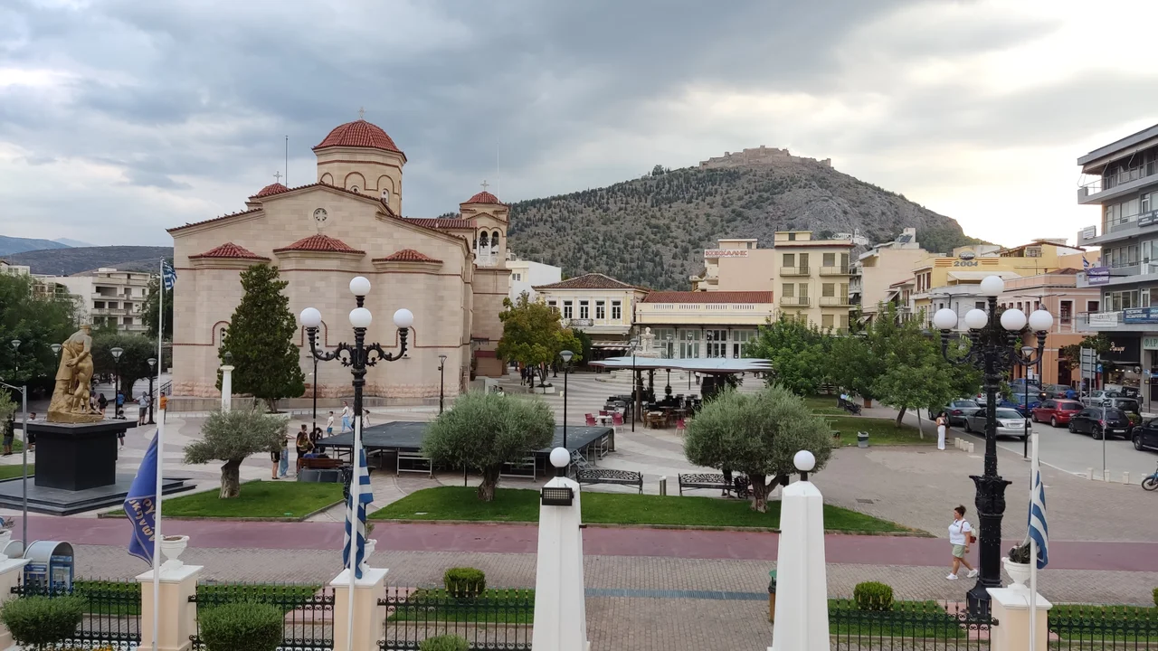
The ancient city of Argos chose its emblem wisely: the wolf. Tenacious, adaptive, territorial — it is a fitting symbol for a settlement that has been continuously inhabited longer than almost anywhere else in Europe. Cities from Troy to Carthage rose and fell; Argos endured. Today it is a working Greek city of around 21,500 people, the largest urban centre in the Argolis region, going about its business in the broad plain below the Larissa citadel with the calm confidence of somewhere that has already outlasted empires and expects to outlast a few more.
The Plain and the Citadel
The landscape around Argos explains its persistence. Set in a wide, fertile plain at the northern end of the Argolic Gulf, the city commands some of the most productive agricultural land in the Peloponnese. The hill of Aspis rises to the southwest — its name means shield — and beyond it, visible from most of the city, the medieval fortress of Larissa crowns a higher summit. In antiquity, Argos was the dominant power of the Argolid, its influence stretching across the peninsula and into the Aegean world. The mostly dry Xerias river runs along the western edge of the modern city, a thread of memory connecting the ancient landscape to the present. Mycenae lies to the north, Tiryns to the east, Nafplio to the southeast: Argos sits at the centre of one of the greatest concentrations of Bronze Age civilisation on earth.
Layers of Living History
Walking into Argos today, you find the ancient and the everyday occupying the same space without apparent friction. The archaeological sites of ancient Argos sit within the urban fabric — including a remarkably well-preserved ancient theatre, cut into a hillside not far from the town centre. The Byzantine Museum of Argolida occupies the Kapodistrias Barracks, a building that itself layers periods: the Kapodistrias name recalls Ioannis Kapodistrias, the first governor of independent Greece, who made nearby Nafplio his capital. The town's monastery, Panagia Katakekrymeni, adds another devotional stratum. The Archaeological Museum of Argos, when open, holds finds from excavations spanning prehistory through the Roman period. In the broad Dimokratias square, a flea market runs every Wednesday and Saturday — commerce as old as the city itself, still going.
Life in the Squares
Argos organises itself around two main squares. Saint Peter's square — Agios Petros — anchors the city's daily rhythm: taxis wait in its corners, the cathedral stands at its edge, the old town hall offers a public balcony from which you can look out over the roofscape toward the surrounding hills. After a major renovation completed around 2016, the square was expanded to include a pedestrian bridge and an artificial lake beside the cathedral, bringing a contemporary touch to an ancient centre. The second square, Dimokratias, hosts the flea market and connects to the pedestrian streets — pezodromoi in Greek — that run through the town's commercial heart. The streets of Eleftheriou Venizelou, Panagi Tsaldari, and Mihail Stamou form the core of this walkable zone, where most of the cafes, shops, and restaurants are concentrated.
Nearest Neighbours, Oldest Rivals
Argos's identity cannot be understood without its neighbours. Nafplio, just eleven kilometres southeast, was the first capital of independent Greece — and is, by a considerable margin, the more visited of the two cities. Nafplio is prettier, more polished, a place that has invested in its tourist-facing self. Argos is something different: a city that has been living its own life for three thousand years and does not particularly feel the need to explain itself to visitors. To the southwest, near the road that once led in antiquity from Argos to Tegea and Arcadia, sits the enigmatic Pyramid of Hellinikon — a small grey limestone structure whose purpose has been debated since the ancient geographer Pausanias described it in the 2nd century AD. Mycenae to the north and Tiryns to the east round out a day's itinerary that could reasonably be called the heaviest concentration of ancient Greek archaeological sites within easy reach of any single city in Greece.
From the Air
Argos lies at 37.617°N, 22.717°E in the broad plain at the northern end of the Argolic Gulf, visible from the air as a sizeable urban cluster surrounded by agricultural fields. The Larissa hill and its fortress rise clearly above the city's southern edge, providing a natural navigation landmark. The Argolic Gulf is visible to the southeast, with the peninsula of Nafplio distinguishable at the coast. The nearest major airport is Athens International Eleftherios Venizelos (LGAV), approximately 130 km to the northeast. A low-altitude pass from the north along the plain reveals the full layout of the Argive basin — with Mycenae's acropolis visible on the hills to the north and the Tiryns ruins discernible closer to the coast. Visibility across the plain is typically excellent in clear summer conditions.
Nearby Stories
- Kastanitsa 2.3 km away
- Heroon at Nemea 3.4 km away
- Psari, Trikolonoi, Arcadia 4.2 km away
- Siege of Gardiki-Arcadia 8 km away
- Cleitor 12 km away
- Troezen 15 km away
- Cave of Euripides 24 km away
- SS Heraklion 94 km away