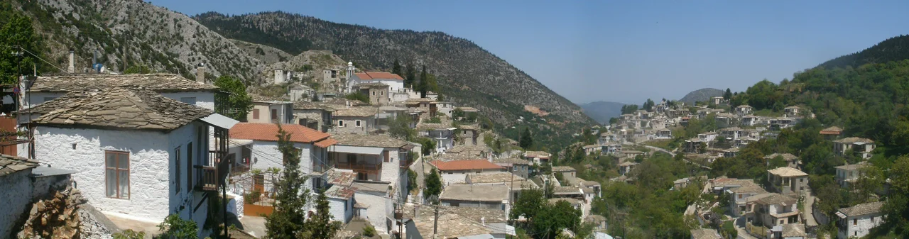

Kastanitsa
The road to Kastanitsa ends where cars must stop. A sign at the village edge asks visitors to leave their vehicles in the designated lot and continue on foot — a small rule that preserves something larger: the feel of a place built for human scale, not for traffic. The stone houses climb the southern face of Mount Parnon in tight, irregular terraces, their slate roofs the color of cold ash, their walls drawn from the mountain itself. Roughly fifty people live here year-round. In summer, the number swells as families return from Athens and other cities. In October, the whole slope fills with the smell of roasting chestnuts.
Refugees Who Became Founders
Kastanitsa does not appear in documents until 1293, but the settlement is thought to be nearly two centuries older than that first written record. The Tsakonian people — speakers of a language descended from ancient Doric Greek, distinct from modern Greek in ways that still puzzle linguists — fled southward into the Parnon range when Slavic tribes pushed into the Peloponnese. They found shelter in the high valleys and built new communities there. Kastaniot tradition names two families as the village's founders: Pentalonas and Bezenikos. Their descendants shaped a settlement that outlasted the Byzantine Empire, the Fourth Crusade, and the Ottoman centuries that followed. The name itself is rooted in the land: kastano, chestnut, for the forests that fed and clothed and sustained them.
A Fort on the Hill of Pyrgos
The hill above the village still bears the name Pyrgos — tower. On it stood the Byzantine fort of Koutoupou, built during the long and bitter contest between the restored Byzantine monarchy and the Frankish lords who had carved the Peloponnese into fiefdoms after the Fourth Crusade sacked Constantinople in 1204. The fort watched over a valley already old with settlement, a garrison perched at the edge of a landscape the Tsakones had claimed as their own. Centuries later, on 21 July 1821, the people of Kastanitsa climbed that same hill and proclaimed their independence from Ottoman rule from the top of the old Byzantine tower. The act was both symbolic and defiant — the ruins of empire repurposed for a new beginning.
What the Travelers Recorded
Two outsiders passed through Kastanitsa within twenty years of each other and left accounts that frame the village's arc. In 1788, the French traveler Villehouson counted four hundred houses and wrote of a thriving settlement. In 1808, the Englishman Martin Leek recorded a more elegiac impression: "This was once a city of great note." Both were right, in different ways. The intervening decades saw Ibrahim Pasha of Egypt — fighting on behalf of the Ottoman sultan against the Greek independence movement — sweep through the Peloponnese and devastate entire regions. Kastanitsa survived, but reduced. Many nearby villages did not recover at all. Those that escaped destruction lost population gradually to economic migration across the nineteenth and twentieth centuries. The village today holds around 250 inhabitable houses, a significant decline from Villehouson's count, though the stone walls of most still stand.
Chestnuts, Plaster, and the Long Winter Road
The forests that named the village still surround it. The largest chestnut grove covers 4,500 acres, and in productive years the trees once yielded up to four hundred tonnes of chestnuts annually. The nuts were eaten, but also boiled down to produce dye for leather — a cottage industry that connected the mountain village to markets far below. Alongside the chestnut harvest, thirty lime kilns produced plaster, and this gave the men of Kastanitsa their winter trade. When the feast of Saint Demetrius arrived in late October, the plasterers departed — traveling as far as Attica, hundreds of kilometers north — and did not return until Holy Week in spring. The rhythm was as fixed as the seasons: leave in autumn, return for Easter, spend the summer with family and forest. The automobile age eventually dissolved that rhythm, drawing people away for good rather than just for winter.
Stone, Slate, and Catherine the Great
Greek heritage law governs what may be changed on the outside of Kastanitsa's houses, which are classified as a heritage site. The slate roofs — practical as much as beautiful, chosen because slate absorbs almost no water and resists the frost that comes hard every winter — give the village a uniform, pewter-colored skyline. At its center stands the Church of the Transfiguration, built in 1780, its interior enriched by Russian woodwork funded by Elias Manesi — a Kastanitsan officer in Catherine the Great's service — and crafted in Odessa in 1818. Nearby, the Church of Saint Pantaleon occupies the ruins of the monastery of Saint Nicholas, founded in 1628 and destroyed by Ibrahim Pasha in 1826. Fifteen smaller country chapels dot the surrounding hillsides. Each August 6th, the Feast of the Transfiguration draws the village together. Each October, the Chestnut Festival does the same — a celebration that connects the present to the forest, and to the families who first chose this particular slope of Parnon and gave it a name.
From the Air
Kastanitsa sits at 37.26412°N, 22.649716°E on the southern slope of Mount Parnon in the Peloponnese, Greece. Approaching from the air, the village is recognizable by its dense slate-roofed stone cluster amid the broad chestnut forests of the Parnon massif. Recommended viewing altitude is 3,000–5,000 feet AGL, which reveals the terraced layout and the hill of Pyrgos above the village. The nearest major commercial airport is LGKL (Kalamata International), approximately 60 kilometers to the southwest. The regional airport at Sparta (no scheduled service) lies closer, roughly 30 kilometers to the northwest.
Nearby Stories
- Psari, Trikolonoi, Arcadia 6.7 km away
- Evrotas Valley 12 km away
- Siege of Gardiki-Arcadia 12 km away
- Lerna 13 km away
- Troezen 15 km away
- Conquest of Coron (1685) 21 km away
- The Dokos Shipwreck 23 km away
- SS Heraklion 83 km away