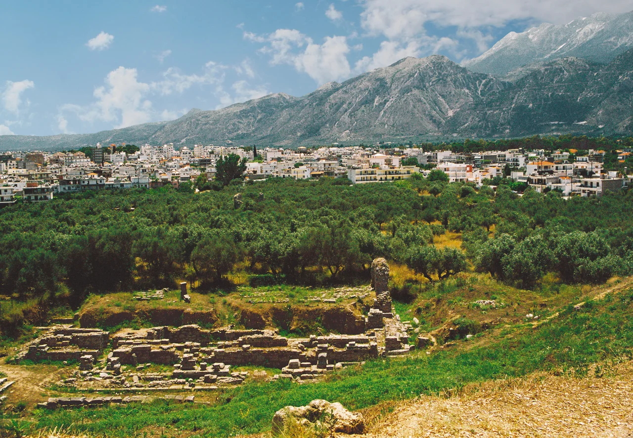

Evrotas Valley
Homer called it *Kili Lakedemon* — the hollow of Lacedaemon. The name captures the geography precisely: an elongated basin, 82 kilometers long, pressed between two mountain masses, with the Evrotas River threading through its floor from the uplands to the sea. Taygetos rises to the west, its highest summit reaching 2,405 meters; Parnon walls the east, lower but still formidable. Between them lies the valley that fed ancient Sparta, sheltered Byzantine Mystras, grows the Peloponnese's largest orange crop today, and bakes in summer heat that has no equal in Greece.
The River That Made Sparta
The Evrotas River is the valley's axis. It begins in the northern reaches of the Taygetos range, collects water from the mountain creeks that wash down on both sides of the valley, and runs south to a delta in the Laconian Gulf. Sparta was built on its west bank, and the city's relationship to the river was fundamental — the flat, well-watered land along the Evrotas sustained the agricultural base that freed Spartan citizens from the labor that Helots performed.
Modern Sparta occupies the same site. The ancient acropolis lies just north of the modern city center, and the Taygetos massif fills the western horizon from anywhere in the valley. At 2,405 meters, the Profitis Ilias summit — likely the mountain that Pausanias called Taléton — is the highest point in the Peloponnese and an ultra-prominent peak visible even from the Isthmus of Corinth. Numerous creeks descend from its flanks. The western side of the Taygetos drains into the Vyros Gorge, which empties into the Messenian Gulf at Kardamyli; the eastern side feeds the Evrotas.
Sparta, Mystras, and the Shifting Center
For centuries the Evrotas Valley meant Sparta. The city dominated the region from the archaic period onward, its power built on the backs of the Helots who farmed this land and the Perieci who lived in its satellite towns. Ancient Sparta left almost nothing standing — the Spartans built in wood and did not commemorate themselves in monuments the way Athens did — but the valley itself was monument enough. It fed the warriors.
Beginning in the 13th century, the center of Laconian life shifted. Mystras, built on a spur of the Taygetos about 4 kilometers west of ancient Sparta, became the political and cultural capital. The Palaiologos dynasty — the last Byzantine imperial house — lived there. Artists and scholars flourished in its churches and palaces in the decades before the Ottoman conquest. When Mehmed II took the Despotate of the Morea in 1460, Mystras fell with it. Ancient Sparta, by then barely inhabited, lingered as a village among ruins until 1834, when King Otto of Greece issued a decree for a new city.
Bavarian city planners headed by Fr. Stauffert laid out the new Sparta on a neoclassical grid, designed for 100,000 inhabitants. The city that exists today is more modest but maintains that original design: wide streets, large squares, trees. The City Hall, built in 1909 to designs by the Greek architect G. Katsaros, stands in the central square.
Oranges, Olives, and Cotton
The Evrotas Valley is agricultural in character. Citrus groves, olive groves, and pastureland occupy the flat land along the river. The valley produces the largest orange crop in the Peloponnese — and quite possibly in all of Greece. *Lakonia*, a brand of orange juice, is based in Amykles, an ancient site now part of the modern agricultural landscape.
The contrast between this productive, sun-drenched basin and the severity of its ancient reputation is striking. The land that made Sparta also makes orange juice. The valley that fed a warrior culture now exports fruit, olive oil, and livestock to the rest of Greece.
The Valley of Fire
Summer in the Evrotas Valley is extreme. The interior is sealed from the sea on all sides by mountains, roughly 30 kilometers from any coast. The meltemi winds that cool much of Greece in summer instead create a foehn effect here: the mountains force the hot air down into the valley rather than allowing it to disperse. The result is the highest summer mean maximum temperatures recorded anywhere in Greece.
On 3 August 2021, the Evrotas station of the National Observatory of Athens recorded 47.4°C. On 30 July 2021, the Kelefina station recorded 47.1°C. In July 2023, the World Meteorological Organization station in Gytheio registered 46.4°C — the highest temperature ever recorded in the National Observatory's network of fan-aspirated stations. On average, the Evrotas station records 43 days per year with temperatures exceeding 40.0°C.
In winter, snow falls on the higher slopes of Taygetos and Parnon. The river runs clear and cold with snowmelt. Then the cycle turns again. The valley heats, the oranges ripen, and the Evrotas moves quietly south toward the sea, as it has since Homer named it.
From the Air
The Evrotas Valley lies at approximately 36.80°N, 22.70°E, running roughly north–south through Laconia in the southern Peloponnese. Kalamata International Airport (LGKL) is about 50 km to the west-northwest. Approaching from LGKL eastward, the Taygetos massif defines the route — its ridge rising sharply before the valley opens below. At 5,000–7,000 feet the full length of the valley is visible: Sparta on the valley floor, the Evrotas River threading south, and the Parnon range forming the eastern wall. The Laconian Gulf and the coast near Gytheio are visible at the southern end. Summer haze from heat can reduce visibility in the valley interior. In clear weather the contrast between the green irrigated floor and the bare rocky mountain flanks is dramatic.
Nearby Stories
- Battle of Agios Vasileios 11 km away
- Battle of Makryplagi 16 km away
- Conquest of Coron (1685) 17 km away
- The Dokos Shipwreck 32 km away
- Hydra: Fire Ships and Stone Mansions 61 km away
- Battle of Cape Spada 107 km away
- Siege of Chania (1645) 168 km away
- Temple of Zeus, Cyrene 417 km away