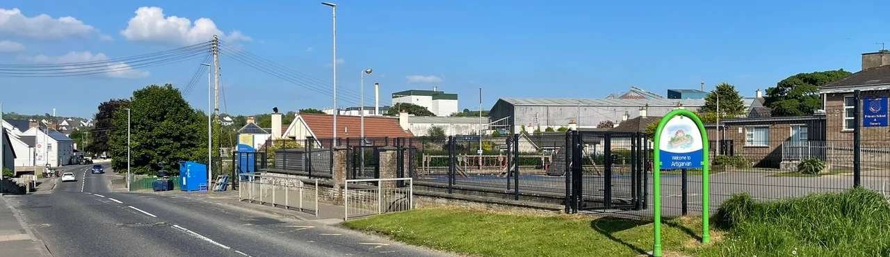

Artigarvan
Artigarvan means height of Garbhan's house. No one quite remembers who Garbhan was, but the name has clung to a Glenmornan Valley village for centuries, repeated on Ulster-Scots tongues as Airtigarvan, fixed onto road signs and council registers. Today some 802 people live here, three miles from Strabane and four from Donemana, on the fertile alluvial plain where the Glenmornan River bends through County Tyrone. The village is small enough to know everyone, and complicated enough that the 2021 census recorded sixteen different combinations of national identity among its residents. Garbhan, whoever he was, picked a thoughtful place to put his house.
The Waterwheel
Before the village had a Spar and a Lakeland Dairies creamery, it had mills - a cornmill, a paper mill, a spade factory - all powered by the same Glenmornan River whose disused mill still stands somewhere near the village edge. One of the local waterwheels, according to librarian and writer Cathal Coyle, measured 20 feet across and ranked among the largest in Ireland. The wheel is long gone, but the bridges that the river demanded remain. Malison Bridge crosses on Berryhill Road in the centre of the village. Catherine's Bridge runs south on Sentry Road. Maccracken's Bridge stands to the north on Station Road. The names are dispatches from a vanished economy, when the river was muscle and the village fed itself on milled grain. The Leckpatrick creamery, established in 1902, still operates on the edge of the village under Lakeland Dairies, the last industrial echo of a milling past.
Walking the Boundaries
Artigarvan townland covers just 174 acres - a postage stamp by Irish standards - but the village as people actually live in it sprawls across the neighbouring townlands of Milltown, Glebe, and Liscurry. All sit inside the historic barony of Strabane Lower and the civil parish of Leckpatrick. Political geography shifts more often than the river. From 1973 to 1985, the village was part of Strabane Area B. From 1985 to 2015, it sat in Glenelly DEA inside Strabane District Council. Since the local government reforms of 2015, it has been part of Sperrin DEA within Derry City and Strabane District Council. Each redrawing of lines on the map has reshaped which neighbours Artigarvan voted with - and, as a result, who its councillors were. The village was historically a unionist place; today's representation tilts nationalist, the consequence of being merged into a larger constituency.
Identity in Numbers
The 2021 census made the village's complexity unusually visible. Of 800 residents who answered the national identity question, 447 called themselves British only, 176 Northern Irish only, 75 Irish only, and 67 some combination of British and Northern Irish. Another 18 chose various combinations - the small numbers that reveal an enormous amount about how individual people hold contested identities together. Ethnicity skewed overwhelmingly white at 99.63 percent. Religion in the wider Artigarvan ward, recorded in 2011, broke roughly to 51 percent Protestant and other Christian, 47 percent Catholic. In a village this size, those numbers describe specific houses, specific neighbours, specific Sunday mornings. The school in the village, Artigarvan Primary, is a controlled school. The nearby Catholic-maintained schools sit in neighbouring villages. Children sort themselves by tradition as their families have done for generations.
Lord Laird of Artigarvan
When John Laird became a life peer in the House of Lords, he had to choose a place name for his title. He picked the village his mother Margaret came from - Lord Laird of Artigarvan - in her honour. A former unionist politician known for his charismatic and at times controversial style, Laird ensured the name of a small Glenmornan Valley village was spoken in the upper chamber of the United Kingdom Parliament. The Spar in the centre of the village is run by John Allen, a former financial advisor, with Gary King. The agricultural merchant Holden Agri and Fuels keeps a small set of fuel pumps for the local farmers. For a covered forecourt, you go a mile to Ballymagorry, to the Centra. For secondary school, the nearest options are Strabane Academy, formed by amalgamation in 2011, or Holy Cross College, Catholic-maintained. For everything else, it is the same Glenmornan road that brought your great-grandparents here, winding gently through fertile pasture under the soft Tyrone sky.
From the Air
Coordinates 54.85 degrees N, 7.40 degrees W, in the Glenmornan Valley about 3 miles north of Strabane in County Tyrone, Northern Ireland. Best viewed at 1,500 to 3,000 feet AGL for the river valley and the broader Foyle Valley complex. Nearest airport is City of Derry Airport (EGAE) about 22 km north. Belfast International (EGAA) is around 110 km east. Letterkenny Airfield (EILT) lies about 18 km west across the Donegal border. Foyle Valley weather is often damp with low cloud.
Nearby Stories
- Donegal Castle 2.2 km away
- Greencastle, County Donegal 3.1 km away
- Dungiven 6.8 km away
- Dunaff 9.7 km away
- Tory Island 12 km away
- Omagh 18 km away
- Gweedore 19 km away
- Castlecaulfield 22 km away