The Night Napa Burned
At ten o'clock on the night of October 8, 2017, the wind was blowing at 28 miles per hour and the relative humidity had dropped to 12 percent. Somewhere on Atlas Peak Road, in the hills above the city of Napa, a fire started. Within hours, it would become one of fourteen large wildfires burning simultaneously across eight Northern California counties -- a catastrophe so widespread that Governor Jerry Brown declared a state of emergency, and journalists reached for the word "firestorm" because nothing smaller seemed adequate.
Tinder and Wind
The conditions that created the Atlas Fire had been building for years. Northern California's Mediterranean climate produces long, dry summers that cure grass and brush into kindling. By October 2017, the hills above Napa were primed. When winds gusted down from the northeast that Sunday night, carrying desert-dry air through the passes and canyons of the Vaca Mountains, the landscape was ready to ignite. The fire started on Atlas Peak, in the heart of one of Napa Valley's most prestigious wine-growing appellations, and pushed south toward the city of Napa itself. The 12 percent humidity meant that vegetation burned fast and completely, leaving nothing to slow the advancing front. Firefighters arriving on scene found a blaze already racing ahead of them, driven by terrain and weather that no amount of manpower could immediately overcome.
A Valley Under Siege
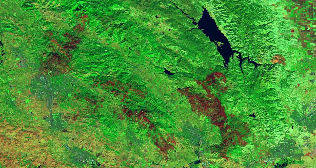
By October 12, the Atlas Fire had consumed 51,057 acres. Its footprint stretched from Lake Berryessa in the north all the way south to the outskirts of Napa -- a swath of destruction that cut through some of the most famous vineyard land in America. Across the region, the scale of displacement was staggering. The evacuation center at Crosswalk Church reached maximum capacity within hours, forcing officials to open additional shelters at Napa Valley College and St. Apollinaris Catholic Church. In Solano County, residents of Upper and Lower Green Valley, Eastridge, and communities along Suisun Valley Road were ordered to leave. Fairfield opened its high school and community college as refuges. In Sonoma, mandatory evacuations rippled outward from Seventh Street East to Castle Road to Lovall Valley Road, each order expanding the circle of displacement as the flames shifted.
Fourteen Fires at Once
What made October 2017 so devastating was not any single blaze but the sheer simultaneity of the disaster. The Atlas Fire was one piece of a regional catastrophe that included the Tubbs Fire in Sonoma County -- which destroyed entire neighborhoods in Santa Rosa -- and a dozen other conflagrations burning from Mendocino to Solano counties. Fire crews and equipment that would normally converge on a single incident were stretched impossibly thin. Every engine, every helicopter, every hand line crew was needed somewhere. The Atlas Fire competed for resources with fires that were, in some cases, even more destructive. This was the brutal arithmetic of the Northern California firestorm: too much fire, spread across too much landscape, for any response to fully contain.
The Firebreak on Atlas Peak Road
On October 12, forecasters predicted winds of 40 miles per hour -- conditions that could have turned the Atlas Fire into something far worse. But the winds arrived lighter than expected, and firefighters seized the opportunity. Crews established a critical firebreak across Atlas Peak Road, the same route where the blaze had originated four nights earlier. That line held. By that day, the fire was 77 percent contained, a number that represented thousands of hours of labor by crews working in smoke and heat and uncertainty. The geography itself had helped: the narrow ridgeline of Atlas Peak channeled the fire along predictable paths, and the road provided a natural break point where crews could cut fuel and dig line with some confidence that the terrain was working with them rather than against them.
Scars on Wine Country
The Atlas Fire left marks on Napa County that extend well beyond the burn scar. Vineyards that survived the flames still suffered from smoke taint -- grapes absorbing compounds from wildfire smoke that no amount of winemaking technique can fully remove. The fire burned through the Atlas Peak appellation, a district known for its Cabernet Sauvignon, and the economic ripple effects reached wineries, restaurants, and tourism operations throughout the valley. But the land recovers. Within a year, green shoots pushed through blackened soil on the hillsides above Napa. Native grasses returned first, then chaparral, then the oaks. The cycle is as old as California itself -- a landscape shaped by fire, adapted to fire, and ultimately renewed by it. The 2017 firestorm was not the first to sweep through these hills, and it will not be the last.
From the Air
Located at 38.39N, 122.24W in the hills northeast of Napa, California. The burn scar extends from Atlas Peak south toward the city of Napa and north toward Lake Berryessa. Atlas Peak (elevation approximately 2,660 ft) is a prominent landmark visible from altitude. The Napa Valley floor and its geometric vineyard patterns provide visual orientation. Nearby airports include Napa County Airport (KAPC) approximately 8nm southwest and Nut Tree Airport (KVCB) approximately 15nm east. The area is subject to seasonal Diablo wind events that create extreme fire weather conditions.
Nearby Stories
- Six Seconds on Moorland Avenue 2.5 km away
- The Lost Flight to Sacramento 2.8 km away
- Rancho Nicasio 7.2 km away
- Yocha Dehe Wintun Nation 8 km away
- The Geysers: Earth's Steam Engine 13 km away
- Feather River 13 km away
- The Last Lakes in the Valley 14 km away
- Before the Cake Was Cut 29 km away