.jpg)
Aughagower
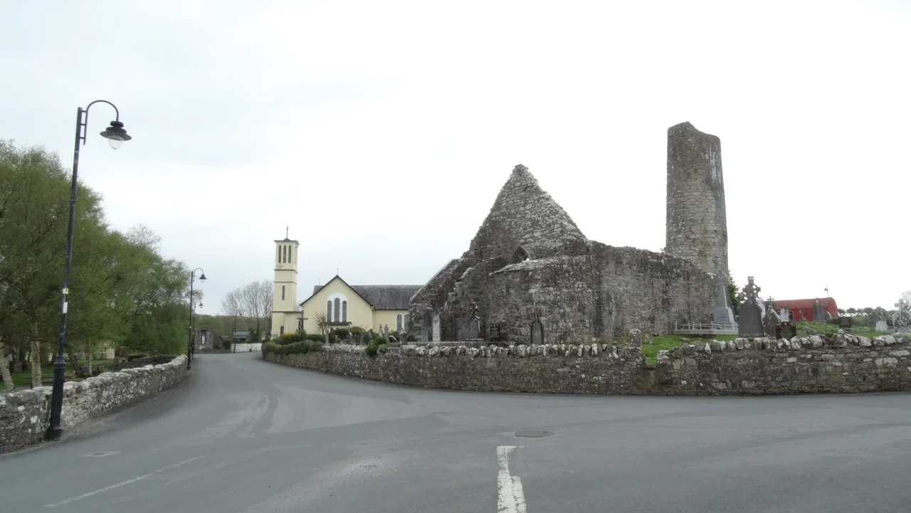
Aughagower has roughly forty houses, a pub, and a shop. It also has a tenth-century round tower in remarkable condition, the ruins of a medieval abbey, a small stone called St. Patrick's Knee with a water-filled depression said to be the saint's own impression, a circular bath called Patrick's Vat, and a 150-kilogram stone called Cloughundra that local folklore says was thrown across fields by a giant. The village sits halfway along Tochar Phadraig, the ancient pilgrim road from Ballintubber Abbey to Croagh Patrick. Pilgrims still walk through. The village's relationship with Saint Patrick is the kind that lasts not centuries but millennia, and the layers of devotion, legend, and stone are still visible to anyone who pulls off the road for an hour.
Patrick Built a Church Here
In 441, according to the Book of Armagh, Saint Patrick founded a church and bishopric at Aughagower and appointed Bishop Senach to head it. Senach was one of Patrick's closest followers, originally from Armagh, who had travelled with him to Mayo as part of his household. The Book of Armagh, written in the early ninth century, recorded that bishops still dwelt at Aughagower in the writer's own time, meaning the bishopric had functioned for at least four hundred years by then. Senach's daughter Mathona founded a nunnery here. The church and nunnery stood about 100 yards north of where the medieval round tower now rises, alongside what was called the Temple of the Teeth, the site of an earlier stone church built atop an original wooden one founded, the tradition holds, by Patrick himself. From the fifth century the parish was one of the most populous and influential in Umhaill, the territory around Clew Bay.
The Round Tower
The tower at Aughagower is one of the best-preserved Irish round towers, missing only its top section and capstone. It was built between 973 and 1013, during the period when these towers proliferated across Ireland in response to repeated raids from Vikings, Norse-Gaels, and warring Irish clans. The towers served several functions: a defensive vantage point from which approaching raiders could be spotted, a fortified storehouse for church treasures, a refuge for the monks themselves in time of attack. The doors of round towers were typically set well above ground level and reached by a ladder that could be pulled up. Aughagower's tower stands beside the ruins of the medieval church, adjoining the modern Catholic graveyard, the three structures spanning more than a thousand years of continuous religious use on a single site.
Patrick's Vat and the Sheela
Dabhach Phadraig, Patrick's Vat or Patrick's Tub, is a circular stone-walled bath where pilgrims would wash their feet, traditionally said to have been used by Patrick himself and his household. Local drainage has left it dry except in extremely wet weather. In a nearby ditch in 2001, a sheela na gig was found, one of the medieval carved female figures that appear on Irish churches and castles. The Mayo Historical Society arranged for it to be fitted to the outside wall of Patrick's Vat. In 2017 it was moved inside, partly for security and partly to make it easier to view, and it now forms part of the eastern wall. Beside Patrick's Vat sits a stone in the graveyard called St. Patrick's Knee, a small recess carved into the rock that fills with water. Tradition says Patrick knelt on this rock and left the imprint, and the water that gathers there is held to be holy. Tobair na Deochain, the Well of the Deacons, is now dried up. A tree that grew over Patrick's Vat was said to have curative powers.
The Giant's Stone
On the village green stands Cloughundra, also rendered Cloch Andra, a large stone of approximately 150 kilograms. Local folklore says a giant in Aughagower used to throw the stone over his shoulder as far as another man would throw a pebble. The stone supposedly bears the trace of his fingers. Strongmen still come to test themselves against it. The stone itself, originally located in a field 2.7 kilometres west-southwest of the village, near the early monastic site of Toberbrendan, may date to the Bronze Age. It is a 2.5-metre spike of shale. On the west face is a cross with a V-shaped ornament beneath it; on the east face, a Latin cross within a double circle and four concentric circles. The cross was carved much later, probably to Christianise what had been a pagan monument. The pattern is common in Ireland: prehistoric standing stones, function unknown, repurposed by the new religion that needed to occupy old sacred ground.
The Carrowkennedy Ambush
On 2 June 1921, in the south of Aughagower parish at Carrowkennedy, an IRA flying column commanded by Michael Kilroy ambushed a mobile patrol of the Royal Irish Constabulary Special Reserves, the Black and Tans. It was one of the few significant engagements of the Irish War of Independence to take place in Connacht. Eight RIC personnel died in the fighting, some killed by their own rifle grenade. After two hours the surviving RIC surrendered. Their weapons and ammunition were taken by the IRA. The prisoners were released. Many of the ambushers afterwards took refuge in the network of safe houses across Mayo and Galway. A century later, a more recent thread connects Aughagower to international affairs: the grandparents of Canadian Prime Minister Mark Carney emigrated from this village in the early twentieth century. In May 2025, locals prepared for a possible visit from him, the longest possible loop closed in a small Mayo village still holding to the work begun by a fifth-century missionary.
From the Air
Coordinates: 53.7635 N, 9.464 W. Aughagower sits about 6 km southeast of Westport in central County Mayo. From the air the village is small, but the surrounding fields and the line of Tochar Phadraig running west toward Croagh Patrick give the area visual coherence. Croagh Patrick is clearly visible 12 km to the west. Nearest airports: Ireland West Knock (EIKN) about 40 km east-northeast, Galway (EICM, GA only) about 85 km south. Recommended viewing altitude 2,500 to 4,000 ft.
Nearby Stories
- Toombeola 1.6 km away
- Aughnanure Castle 3.7 km away
- Inishbiggle 5.2 km away
- Uggool Beach 7.4 km away
- Ballyhaunis 7.4 km away
- Crossmolina 15 km away
- Ballymote Castle 22 km away
- Ahascragh 31 km away