Twelve Thousand Bolts
The National Weather Service office in the Bay Area used a word rarely found in official forecasts: "insane." It was the early morning of August 16, 2020, and in the span of thirty minutes, 200 lightning bolts had hammered the region. By the time the storm system passed, over 12,000 strikes had been recorded across Northern California in a 72-to-96-hour siege. Nearly every bolt was dry lightning -- brilliant, violent, and accompanied by almost no rain. Each strike landed in a landscape parched by record heat and years of drought. Within days, 650 wildfires were burning simultaneously, and the scale of destruction would produce a single fire larger than any in California's modern history.
A Storm Born from a Dying Hurricane
The atmospheric chain of events that produced the lightning siege was extraordinary. Tropical Storm Fausto, weakening off the coast of Baja California, shed a plume of moist, unstable air that abnormal winds carried northward -- streaming from as far as 1,000 miles offshore into Northern California. This moisture collided with a high-pressure ridge parked over Nevada, the same system responsible for a brutal, record-breaking heat wave baking much of the West. The combination was volatile: hot, dry air at the surface with moist, convective air aloft. Between August 14 and 16, Northern California recorded record-breaking temperatures. The National Weather Service issued a Fire Weather Watch on the morning of August 15, upgraded it to a Red Flag Warning that afternoon, and by dawn on August 16 the first thunderstorms were already igniting the landscape. The storms produced almost no rain. Lightning struck into tinder.
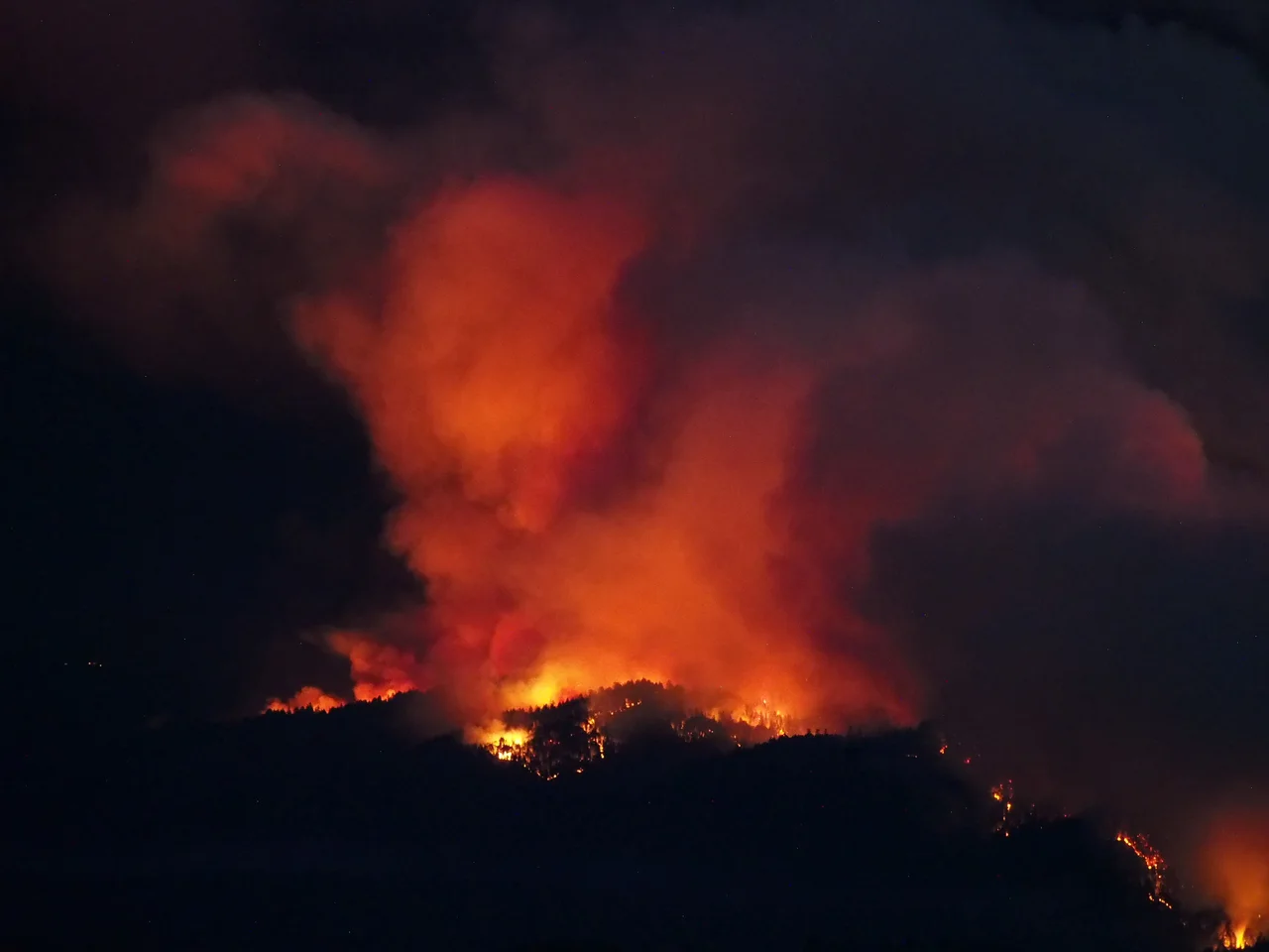
Six Hundred and Fifty Fires
The sheer number of simultaneous ignitions overwhelmed firefighting resources in a way California had never experienced. Many of the fires started on August 16 and 17. Some were quickly knocked down at an acre or two. Others, fanned by dry winds and feeding on parched brush, exploded out of control within hours. Three massive fire complexes emerged from the chaos. The SCU Lightning Complex, the LNU Lightning Complex, and the CZU Lightning Complex -- named for the Cal Fire administrative units where they burned -- collectively scorched approximately 846,000 acres by mid-September, destroyed 2,723 structures, and killed six people. In Napa County, the LNU complex's Hennessey Fire leapt from five acres to 2,400 in a single day, driven by gale-force winds of 20 to 40 miles per hour. By August 20, the LNU complex alone had consumed 215,000 acres and 480 structures.
Door to Door in Vacaville
On August 19, the LNU complex fire raced toward Vacaville, a city of 100,000 in Solano County. Police officers and firefighters went door to door, urging residents to leave immediately. Families fled with whatever they could grab -- documents, pets, the clothes they were wearing. The forced evacuations spread across counties: Healdsburg, which had already evacuated twice in three years during the Tubbs and Kincade fires, emptied again. Personnel at Travis Air Force Base were partially evacuated. In the Santa Cruz Mountains, the CZU complex tore through Big Basin Redwoods State Park, California's oldest state park, causing extensive damage to ancient groves. Towns like Pescadero and La Honda waited under evacuation warnings, watching the ridgelines for the orange glow that meant the fire was approaching. The human reality of these fires was not the acreage statistics but the repeated displacement -- people who had rebuilt after one fire now fleeing from another.
The Monster That Set the Record
While the Bay Area complexes drew the most immediate attention, the largest single fire was burning farther north. The August Complex, ignited by lightning in the Mendocino National Forest, grew steadily through September. On September 10, it surpassed the 2018 Mendocino Complex to become the largest wildfire in modern California history, reaching 471,185 acres. The next day it merged with the Elkhorn Fire, another massive blaze of 255,039 acres, creating a combined footprint of 746,607 acres -- more than 1,100 square miles, larger than the state of Rhode Island. Farther north still, the North Complex fire's Bear Fire destroyed the small community of Berry Creek. Each of these fires, born from the same lightning siege, could have been the dominant natural disaster of any normal year. In August 2020, they were competing for attention.
The Day the Sky Turned Orange
On September 9, 2020, residents of the San Francisco Bay Area woke to an apocalyptic sky. Wildfire smoke, lofted high into the atmosphere by the intense heat of the fires, had been carried back over the region by offshore winds. The smoke layer filtered sunlight so completely that the sky turned a deep, eerie orange -- dark enough at midday that streetlights stayed on and cameras struggled to capture the color accurately. Social media filled with images that looked like science fiction. The orange sky became the defining visual of the 2020 fire season, a single image that conveyed what statistics could not: the fires had altered the atmosphere itself. Air quality across the region plummeted to hazardous levels, forcing millions indoors during a pandemic that already had them sheltering in place. For weeks, the fires burned. Six of the twenty largest wildfires in California history were products of the 2020 season, and four of those emerged from the August lightning siege -- a single weather event that reshaped the record books.
From the Air
This event spanned much of Northern California, with the primary fire complexes located across the Bay Area, Sonoma-Napa wine country, the Santa Cruz Mountains, and the Mendocino National Forest. The coordinates 37.50N, 119.77W place the article near the Sierra foothills, but fire activity extended from the Oregon border to Monterey County. Major airports affected included San Francisco International (KSFO), Oakland International (KOAK), San Jose International (KSJC), and Sacramento International (KSMF). Smoke impacts extended hundreds of miles from fire perimeters, creating IFR conditions and flight restrictions across the region.
Nearby Stories
- Coarsegold, California 0.6 km away
- The Lodge That Outlasted the Gold 3.1 km away
- The Curve Over the Canyon 14 km away
- Camp Mather 17 km away
- Mono Lake: Where Salt Towers Rise From Dying Water 28 km away
- California Central Valley Grasslands 30 km away
- Mono Lake 56 km away
- Sequoia: Standing Among the Largest Living Things on Earth 102 km away