Coarsegold, California
Every autumn, thousands of male tarantulas emerge from their burrows in the oak-studded hills around Coarsegold, California, and march across roads and trails in search of mates. The town throws them a festival. This is the kind of place Coarsegold is - small enough (population 4,144) that the mating habits of local spiders constitute a civic event, old enough that its name recalls the rough nuggets Texas miners pulled from a gulch here in 1849, and situated precisely where the flat heat of the San Joaquin Valley surrenders to the Sierra Nevada foothills along Highway 41, the road to Yosemite. Madera County's last surviving gold town has outlasted the mines, the stagecoaches, and most of the neighboring settlements by finding new reasons to exist in each passing era.
Eight Thousand Years Before the Gold
The Chukchansi were here long before anyone thought to name the gulch. Their presence in this region reaches back over eight thousand years, making the Gold Rush a recent interruption in a much longer story. The Chukchansi belong to the Yokuts, a network of approximately sixty tribes linked by linguistic kinship across the Central Valley, each maintaining distinct dialects while sharing cultural patterns of basket-weaving, acorn processing, and seasonal movement between valley floor and mountain meadow. The discovery of gold in 1849 shattered this continuity. Disease spread through communities with no immunity, miners claimed land that had sustained generations of Chukchansi families, and federal policies of forced assimilation - including the removal of children to distant boarding schools - drove a steep decline in the native population. Today, the Picayune Rancheria of Chukchansi Indians is headquartered in Coarsegold, a federally recognized tribe working to preserve the language and traditions that survived the disruption. Their presence is not a historical footnote; it is the oldest continuous thread in the town's identity.
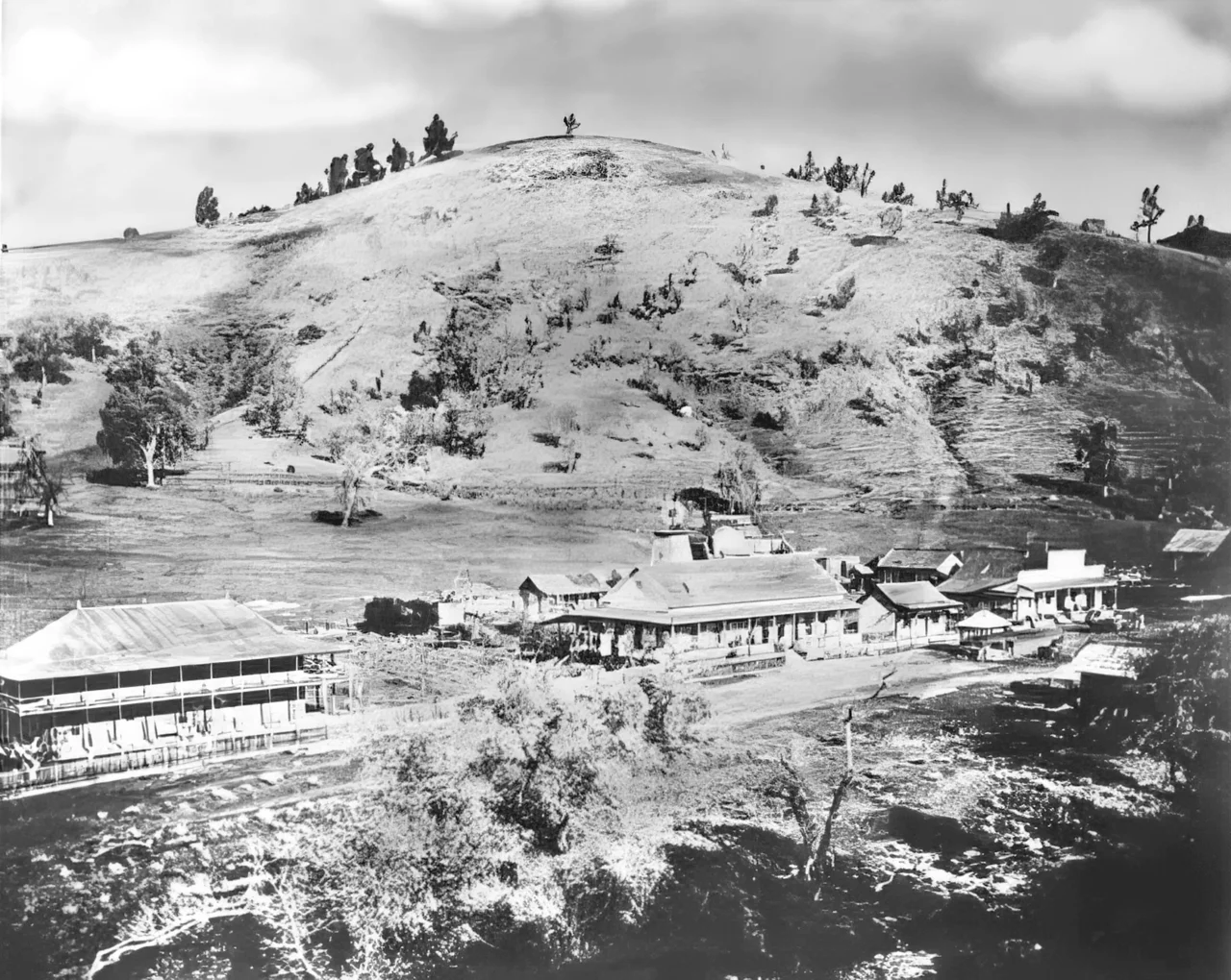
The Crossing
Miners from Texas found coarse gold in the local gulch in 1849, and the rush was on. By 1852, a settlement had coalesced at the only fordable point on the Fresno River, where John Ledford and George M. Carson built an adobe trading post with a store, a saloon, and living quarters. The place was known as The Crossing, and it earned a reputation for violence - enough dead miners were buried on a nearby hill that the location became a local landmark of its own. Goods were scarce and prices punishing, especially for whiskey and flour, the twin essentials of frontier life. The trading post changed hands to J.L. Hunt and J.R. Roan, and at the height of operations, several dozen gold mines worked the surrounding hillsides. The settlement cycled through names - Texas Flat, Coarse Gold Gulch - before the post office finally standardized the spelling to Coarsegold in 1899, after a brief stint as "Goldgulch" that apparently satisfied no one.
Gateway to the Valley of Wonders
By the 1860s, the gold was thinning out, but Coarsegold found a second life as a waypoint. Cattlemen, farmers, and lumbermen heading into the high country all passed through town. When the wagon road to Yosemite Valley was completed in 1876, Coarsegold became a stop on one of the most celebrated tourist routes in the American West, drawing visitors from around the world. Stagecoaches rattled through town loaded with travelers eager to see the granite cliffs and waterfalls that were already becoming famous through the photographs of Carleton Watkins and the writings of John Muir. The boom didn't last. In the 1880s, a new road was cut directly from the valley to the mining settlements at Grub Gulch and Ahwahnee, bypassing Coarsegold entirely on the way to Yosemite. The stagecoach traffic evaporated almost overnight. Coarsegold shrank, but it didn't disappear - a pattern that would repeat.
Jaws, Star Trek, and a Frontier Pharmacist
For a tiny foothill town, Coarsegold has an outsized connection to popular culture. Richard Kiel - best known as the steel-toothed villain Jaws in two James Bond films - lived here from 1980 to 2002. Grace Lee Whitney, who played Yeoman Janice Rand on the original Star Trek, spent her final years in Coarsegold until her death in 2015. Creed Bratton, the actor and musician famous for playing a fictionalized version of himself on The Office, was raised in town. Sierra On-Line, the pioneering game company based in nearby Oakhurst, set its 1993 adventure game Freddy Pharkas: Frontier Pharmacist in a fictional 1880s Coarsegold. The 1962 Western Ride the High Country, starring Joel McCrea and Randolph Scott, used the Coarsegold mining site as its destination. The town seems to attract people and stories in quiet disproportion to its size.
Spiders and Staying Power
The Coarsegold Rodeo has run every first weekend of May since 1953, when the town threw a centennial celebration and decided to keep going. The Tarantula Awareness Festival, now more than twenty-five years old, marks the autumn mating season when male tarantulas become conspicuously mobile. These are not ironic attractions or manufactured kitsch. They reflect a community that pays attention to its own rhythms - the seasonal cycles of livestock and arachnids alike. Coarsegold sits at 2,218 feet elevation, receiving about 27 inches of rain a year, in the transition zone where valley grassland gives way to foothill oak woodland. Ninety percent of homes are owner-occupied, well above California's average of 55.8 percent. The town today draws retirees and commuters who make the drive down Highway 41 to Fresno, but its identity remains rooted in the particular landscape where valley meets mountain - the same landscape that sustained the Chukchansi for millennia, lured Texas miners in 1849, and still sends tarantulas on their annual autumn pilgrimage.
From the Air
Located at 37.262N, 119.701W in the Sierra Nevada foothills of Madera County, California, at an elevation of 2,218 feet. Coarsegold sits along the Highway 41 corridor between Fresno and the southern entrance to Yosemite National Park. From the air, look for the small community nestled in oak-covered rolling hills where the San Joaquin Valley floor transitions to Sierra foothill terrain. Nearest major airport: Fresno Yosemite International (KFAT), approximately 30nm south-southwest. Mariposa-Yosemite Airport (MPI) lies to the north. The terrain rises steadily to the east toward Yosemite. Good visibility most of the year; winter storms and occasional tule fog in the valley below can reduce conditions.
Nearby Stories
- The Railroad Fire 5.1 km away
- The Lodge That Outlasted the Gold 6.7 km away
- Woodward Park 8.4 km away
- California Central Valley Grasslands 21 km away
- Alkali Sink Ecological Reserve: Holding Ground for a Ghost 22 km away
- Mono Lake: Where Salt Towers Rise From Dying Water 64 km away
- Sequoia: Standing Among the Largest Living Things on Earth 73 km away
- The Bristlecone Pines: The Oldest Living Things on Earth 91 km away