Baños
Tungurahua has been erupting, more or less continuously, since the year 2000. The volcano looms above the town of Baños at 5,023 meters, close enough that on clear nights its glow reflects off the clouds. When the intensity picks up - as it does several times a year - ash sometimes dusts the rooftops. In 1999, the whole town was evacuated. The people came back. They always do. This is a place that has made peace with its geology, and then turned around and sold the experience to tourists.
Baths of the Sacred Water
The name is straightforward: Baños de Agua Santa means Baths of the Sacred Water. The sacredness comes from the hydrothermal springs bubbling up from the Andean depths, heated by the same volcanic system that periodically threatens to bury the place. Pilgrims have come here for generations to the Basilica of the Virgin of the Holy Water, a shrine that fills on Sundays with devotees seeking cures. The town sits at 1,800 meters, only about 150 kilometers from the equator, and the altitude gives it a daily temperature that hovers around 17 degrees Celsius year-round. Warm enough to hike in a t-shirt. Cool enough to sleep under blankets.
Adventure Capital
Somewhere along the way, Baños picked up a nickname - Gringobamba - and a reputation as Ecuador's adventure capital. The Pastaza River valley, which begins immediately east of town, is a canyon of waterfalls that has become a playground. The Ruta de las Cascadas, one of Ecuador's most famous biking routes, runs 61 kilometers mostly downhill toward Puyo on the edge of the Amazon. Tour operators offer bridge jumping from two bridges, one much higher than the other, with no liability insurance but professional rigging. Canyoning outfits rappel visitors down waterfalls. Rafting companies run the Pastaza's class II through IV rapids, though safety standards vary and tourists have died. The danger is part of the pitch.
The Taffy Makers
On almost any street in the center of town, someone is making melcocha - Ecuador's hallmark candy, a taffy pulled from boiled raw sugarcane syrup. The technique is theatrical: a long rope of amber candy is slung over a sturdy wooden peg or doorframe and beaten, stretched, folded, and beaten again until it lightens to the color of pale honey. Most of Ecuador's melcocha comes from Baños. The abundance of sugarcane in the region made it inevitable, though the candy has outlived its purely practical origins. Markets sell cuy - roasted guinea pig, an Andean specialty - alongside stacks of sugarcane cut into chewable pulp sticks. Jugo de Caña, freshly pressed juice, is sold by vendors with mechanical presses bolted to their carts.
Under the Volcano
Tungurahua, in Quichua, translates roughly as "Throat of Fire." The name is not metaphorical. During the continuous eruption cycle that began in 1999, the volcano has produced pyroclastic flows, lava, and ash clouds that have forced multiple evacuations and killed residents who returned too soon. Yet life in Baños goes on. Massage studios cluster on a single street, all charging twenty dollars an hour. Salsa bars fill on weekend nights. The Casa del Arbol, a treehouse with a swing that launches riders out over a cliff with Tungurahua framed in the distance, has become an Instagram landmark. Local minivans do scheduled tours of the waterfalls, departing from the bus terminal three times a day, with nocturnal runs at seven and nine for those who want to see Bellavista's lights.
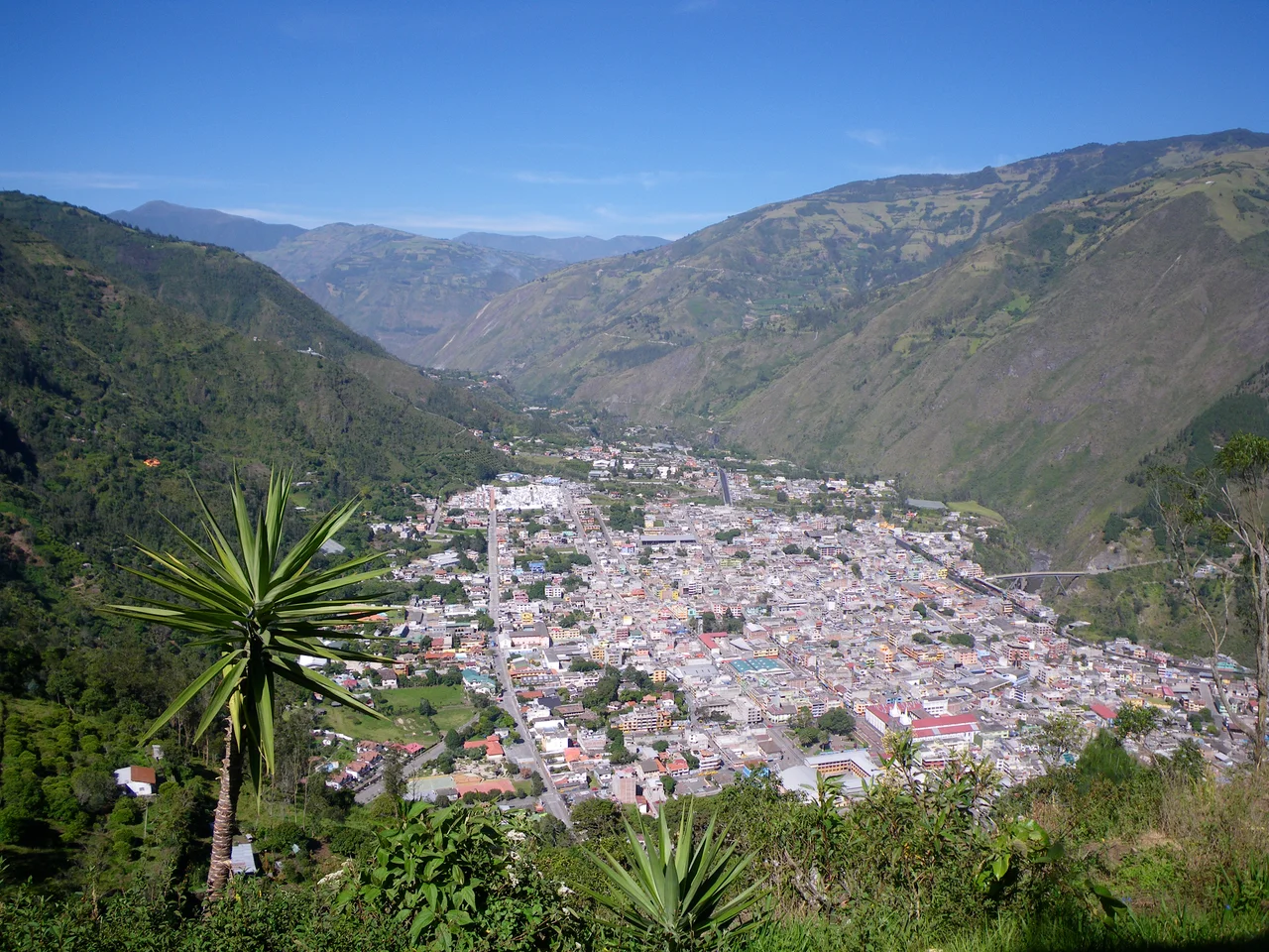
The View from Bellavista
Above town, a trail climbs to Bellavista, where a cross marks one of the best viewpoints over Baños. From here, the town stretches out in the valley below, hemmed in by steep green walls. Eastward, the Pastaza cuts its canyon deeper into the mountains toward the Amazon. Westward, beyond the cloud layer, the pointed cone of Tungurahua sometimes emerges. The volcano has a way of announcing itself unpredictably - a plume of steam one day, nothing the next. Locals have learned to read its moods. Tourists mostly don't. The guides know which days to climb, which to stay down, which routes to close. For a town that lives in the shadow of a mountain that could destroy it, Baños has figured out how to celebrate the relationship rather than fear it.
From the Air
Coordinates 1.40 S, 78.42 W. Elevation 1,800 meters at town center; Tungurahua volcano to the southwest rises to 5,023 meters. The Pastaza River canyon cuts east toward the Amazon. Best viewing from 10,000-15,000 feet in clear conditions; volcanic activity can affect visibility. Nearest major airport: Mariscal Lamar (SEAM) in Cuenca south, or Mariscal Sucre (SEQM) in Quito north.
Nearby Stories
- Riobamba 13 km away
- San Luis de Pambil 18 km away
- La Mana 19 km away
- Puyo, Pastaza 20 km away
- Tena 27 km away
- Laguna Quilotoa 42 km away
- Babahoyo 53 km away
- Borja, Peru 326 km away