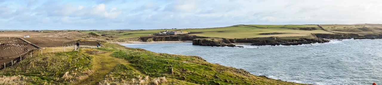

Barclodiad y Gawres
The name translates as 'the apronful of the giantess', and the legend explains the mound's shape - a giant striding from Ireland is said to have dropped her load of stones here, leaving a low grassy hump above Porth Trecastell. The truth is stranger than the folktale. What sits beneath the turf is a Neolithic passage grave built around 5,000 years ago, one of only a handful of decorated tombs in Britain, and the closest cousins to its carved stones lie not in Wales but across the Irish Sea in the Boyne Valley.
Across the Water
Stand on the headland above Porth Trecastell and look west. On a clear day the Wicklow Mountains rise faintly across sixty miles of grey water. That sightline is the key to Barclodiad y Gawres. Its cruciform plan - a central chamber with side cells branching off like a stubby cross - is the signature shape of the great Irish passage tombs at Newgrange, Knowth and Dowth. So are the carvings. Five decorated stones were uncovered when the chamber was excavated in 1952 and 1953, and a sixth was found in 2001. Their lozenges, chevrons, spirals and zigzags belong to the same artistic tradition that flowered along the River Boyne. Whoever built this tomb either crossed the sea themselves or knew people who did, and they brought with them ideas about death and decoration that ran the breadth of the Irish Sea world.
The Last Meal
When archaeologists reached the heart of the chamber they found the remains of a fire, and on the fire, the remains of a stew. The ingredients tell their own story: wrasse and eel from the sea, frog and toad and grass snake from the marshes, mouse and shrew and hare from the fields. After the broth had been poured onto the embers, the whole thing was covered with limpet shells and pebbles, sealing it in place. Two cremated young men lay in the south-western side chamber. Whatever ritual closed this tomb included a feast that was deliberately strange, drawing in creatures from every corner of the Anglesey landscape, as if to invite the whole living world into the dark.
Concrete and Turf
What you see today is partly a reconstruction. After the 1952-53 dig the chamber was re-roofed in concrete and covered with fresh turf to roughly resemble the original mound. Without that intervention the carved stones would now be exposed to Atlantic weather, and the chamber would have collapsed long ago. Cadw, the Welsh heritage body, looks after the site. A heavy iron grille usually closes the passage, though guided open days each summer let visitors crawl inside and trace the spirals with a torch. The locked door is a small price for keeping 5,000-year-old artwork intact above one of the wildest coastlines in north Wales.
Where Land Meets Sea
The setting is half the story. The mound sits a few paces back from a sheer drop above Cymyran Bay, on the Anglesey Coastal Path between Aberffraw and Rhosneigr. Surfers ride the breaks in Porth Trecastell directly below. Westerly gales come in unbroken from the open Atlantic, and the salt finds everything. The Neolithic farmers who raised this tomb chose a spot that announced itself to the sea - visible to anyone arriving by boat from Ireland, and aligned with the long, low horizon where their ancestors had come from. Five millennia later the view is still doing the same work.
Sister Sites in the Dark
Decorated Neolithic monuments are vanishingly rare in Britain. Outside Orkney's Maeshowe, Barclodiad y Gawres and nearby Bryn Celli Ddu are the only mainland examples with significant abstract art. Together they make Anglesey the western edge of a cultural province that runs from the Boyne to the Bay of Biscay. Standing in the chamber on a still evening, with the surf hissing on the rocks below and the spirals just visible in the torchlight, the distance between Anglesey and Ireland feels less like a sea and more like a shared room.
From the Air
Located at 53.21 degrees north, 4.50 degrees west on the south-western tip of Anglesey, the small grass-covered mound sits on the cliffs above Porth Trecastell, two miles south-east of Rhosneigr. Best viewed from 1,500 to 2,500 feet for context with the coastline. RAF Valley (EGOV) is six miles north; Caernarfon Airport (EGCK) lies 15 miles south-east across the Menai Strait. Watch for restricted airspace around RAF Valley, an active fast-jet training base.
Nearby Stories
- Wakestock 1.7 km away
- Trefriw 3.8 km away
- Irish Sea 8.7 km away
- Irish Sea Bridge 20 km away
- East–West Interconnector 30 km away
- Machynlleth 36 km away
- HMS Tyler 41 km away
- New Brighton Lifeboat Station 54 km away