Barotse Floodplain
Every year, the Zambezi does something that sounds like myth and turns out to be engineering. It rises across a flat plateau of Kalahari sand in western Zambia and spreads itself thin over an area larger than Jamaica. Cattle are moved. Villages empty and refill according to the water. And the Litunga, the king of the Lozi people, boards a great black-and-white barge called the Nalikwanda and is paddled from his lowland capital at Lealui to higher ground at Limulunga. This is Kuomboka - "to get out of water" - and it has been happening for centuries, long before the word "Zambia" existed on any map.
The Plain and Its People
The Barotse Floodplain, also called the Bulozi Plain, Lyondo, or simply the Zambezi Floodplain, is one of Africa's great wetlands. Its main body covers about 5,500 square kilometers, but in high-flood years the connected floodplains of its tributaries push the inundated area to 10,750 square kilometers - second only in Zambia to the Lake Bangweulu system. The name recognizes a specific human truth: this floodplain gave rise to the Lozi nation. "Rotse" is a variant of Lozi, and "Ba" means people. Their kingdom, Barotseland, extended up to 300 kilometers from the plain under the 19th-century king Lewanika, who negotiated with European powers to preserve a measure of autonomy that the Lozi still reference today. The annual flood is not a disaster. It is the calendar. Fish spawn. Grass grows lush. The sediment that makes cattle fat comes from a thousand kilometers upstream.
Geography of a Slow Flood
The plateau sits at about 1,000 meters elevation, tilting almost imperceptibly to the south. Rain falls heavily on the highlands to the north - around 1,400 millimeters a year in the wet season from October to May - and the flood crawls down the Zambezi into a basin of Kalahari sand roughly 500 kilometers across. Without a natural barrier, the river would cut deep channels and move on. But 230 kilometers to the south, around Ngonye Falls, harder rock refuses to erode. It holds like a natural dam, and behind it the water spreads. Below the falls, the Zambezi flows almost twice as fast through a narrow valley. Above them, it wanders. The floodplain stretches from the river's confluence with the Kabompo and Lungwebungu in the north to a point south of Senanga, its width rarely less than 30 kilometers, reaching 50 kilometers at its broadest, just north of Mongu.
Kuomboka and the Litunga's Two Capitals
Lealui is the royal capital on the plain itself - a cluster of houses and the Litunga's kashandi surrounded by shining water in the wet season. Limulunga is the capital on higher ground, where the Lozi court retreats when the flood arrives. The move between them is one of Southern Africa's most striking ceremonies. The Litunga rides the Nalikwanda, the royal barge, its hull painted in alternating black and white stripes to echo the pattern of a zebra. Paddlers in dark red berets drive her across the water in time to drums. Thousands gather on both banks. Kuomboka is not a tourist performance, although tourists come. It is a statement about who the Lozi are and where the water stops being a problem and starts being home.
The Road Across the Water
For decades, Mongu, the principal town at the plain's edge, and Kalabo, on the far side, were separated in the wet season by an uncrossable shallow sea. A road was attempted and abandoned: contractors underestimated the floodplain and walked away. Later engineers raised the roadbed and added more and larger culverts, running into funding trouble along the way. The Aviation Industry Corporation of China - AVIC International - eventually finished the 286.9 million dollar project in 2016. The 34-kilometer Mongu-Kalabo road carries 26 bridges across the floodplain. Driving it now, you cross open water in the wet season and grassland in the dry, with the Nalikwanda's barge channel somewhere off to the side. Upstream lies Liuwa Plain National Park, home to one of Africa's largest wildebeest migrations. Downstream, beyond Ngonye Falls, the Zambezi gathers speed toward Victoria Falls. The plain itself remains what it has always been: the Zambezi's pause, drawn out across a landscape that the Lozi have named, loved, and lived by for longer than anyone can count.
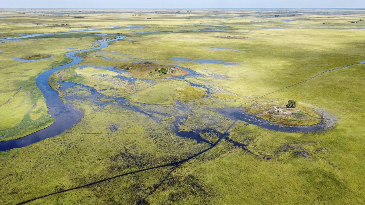
From the Air
Coordinates 15.03 degrees south, 22.88 degrees east, elevation approximately 1,000 meters. The Barotse Floodplain is one of the easiest features to identify from the air in all of southern Africa - in the wet season, a silver-green inland sea bounded by Kalahari woodland, and in the dry season, a pale grassland threaded by the meandering Zambezi. Nearest major airport is Mongu (FLMG) on the eastern edge. Cruise at 5,000 to 7,000 feet AGL to read the channel braiding and flood extent. The annual Kuomboka ceremony typically falls in late March or early April, when floodwaters peak.
Nearby Stories
- Liuwa Plain National Park 58 km away
- Kabompo 150 km away
- Kafue National Park 232 km away
- Mavinga National Park 260 km away
- Itezhi-Tezhi Dam 269 km away
- Bwabwata National Park 297 km away
- Cuito Cuanavale 358 km away
- 1985 Aeroflot Antonov An-12 Shoot-Down 471 km away