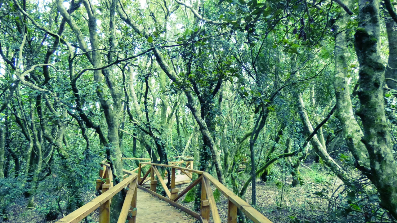

Bosque de Fray Jorge National Park
Climb the ridge of the Cordillera de Talinay and the desert simply stops. One moment you are walking through pale, dry scrubland where barely four inches of rain fall in a year. The next, you step into a forest so wet that water beads on every leaf and moss carpets the ground. There are no rivers feeding it, no rain to speak of. This forest drinks fog. Along the high coastal slopes, a thick gray cloud the Chileans call the camanchaca rolls in off the Pacific and snags in the canopy, and the trees comb the moisture out of the air drop by drop. Bosque de Fray Jorge is a fragment of another world, stranded a thousand kilometers north of where it belongs.
A Forest Out of Place
These are Valdivian temperate rainforest trees, the kind that properly belong far to the south in cool, soaking Patagonia. Here they cling to the coastal range of the semi-arid Coquimbo Region, the northernmost outpost of their kind. Olivillo trees with their dark, glossy leaves dominate the canopy, tangled with arrayanes, ferns, and epiphytes that hang from the branches like green rags. The whole grove is small, scattered in pockets across the ridgetops where the fog reaches highest. Below and all around stretches dry matorral scrub, cactus, and bare stone. The contrast is so abrupt that botanists treated the place as a living puzzle long before they could explain it. How does a rainforest grow where it almost never rains?
Survivors of Deep Time
The answer reaches back further than anyone first guessed. For decades the forest was read as a relic of the last Ice Age, a damp pocket left over when glacial-era forests retreated. More recent genetic work tells a deeper story. Studying tiny land snails and other small creatures locked in the grove, researchers found that Fray Jorge split from its southern cousins more than twenty million years ago, a remnant of forests that once spread across this landscape during the Paleogene and Neogene. As the climate dried and the desert advanced, those forests died back everywhere except the few ridges where the camanchaca kept condensing. What survives today is an island in time as much as space, holding on by the thinnest of margins on a sea of moving cloud.
Fog as Lifeblood
Everything here depends on a single daily ritual. Cold Pacific currents chill the air offshore, and the resulting fog bank climbs the coastal range until the trees intercept it. Their leaves and branches strip water from the cloud, and it falls to the forest floor as a slow, steady drip that can far exceed the meager rainfall. Walk the boardwalks on a foggy morning and the canopy is invisible overhead, the light gone soft and gray, the trail slick and the air cool and salt-edged. The same phenomenon inspired the fog-catching mesh nets that Chilean scientists have used in this region to harvest drinking water from thin air. Fray Jorge proves the trick on a forest's scale, and has done so, silently, for millions of years.
A Friar's Errand
People found the forest the way they found most useful things in the colonial north: by needing it. The story goes that in 1627 a Franciscan friar, short of timber in this treeless country, went searching with a string of mules and discovered the grove, then carried wood back to help build the bell tower of the Church of San Francisco in La Serena. The forest kept the friar's name. In 1941 Chile made it a national park, now managed by the forest authority CONAF, and in 1977 UNESCO recognized it as a biosphere reserve. Its southern edge runs down to the Limarí River, whose lower reaches were named a protected Ramsar wetland in 2020. Degus and chinchillas rustle in the undergrowth, foxes pad the trails, and the Chilean tinamou calls from the scrub at the forest's dry frontier.
From the Air
Bosque de Fray Jorge National Park sits at roughly 30.66°S, 71.68°W, on the Cordillera de Talinay coastal range about 100 km south of La Serena and 30 km west of Ovalle. The forest hugs ridgetops at a few hundred meters elevation, right where the Pacific fog bank breaks against the coast. From the air the green crowns stand out sharply against the surrounding tan desert and the long Pacific shoreline; the Limarí River marks the park's southern boundary. The nearest airport is La Florida (ICAO: SCSE) at La Serena to the north. Expect a thick coastal cloud deck and reduced visibility over the ridgeline in the morning and evening hours, often burning off to clear skies inland by midday.
Nearby Stories
- Cerro Tololo Inter-American Observatory 33 km away
- Carmen de Andacollo 47 km away
- Las Chinchillas National Reserve 77 km away
- Pisco Elqui 79 km away
- El Leoncito National Park 184 km away
- Constitución, Chile 490 km away
- Santa Olga 532 km away
- 1687 Peru Earthquake 1734 km away