The Sleeping Caldera of a Thousand Temples
Three lakes fill the floor of a caldera that has not erupted in recorded human history, and each one is sacred. Bratan, Buyan, and Tamblingan sit in the collapsed heart of the volcano the Balinese call Catur, nestled in the highlands of northern Bali at roughly 1,200 meters above sea level. Below the still surface of these lakes, a magma chamber continues to heat groundwater that escapes as hot springs and fumaroles across the volcanic complex. The mountain is dormant, not dead -- and the Balinese have built their spiritual life around that distinction.
Architecture of Collapse
The Bratan volcanic complex, also known as Catur or Tjatur, sprawls across an area of approximately 11 kilometers on the northern side of Bali. It is a caldera -- a broad depression formed when a volcanic summit collapses inward after emptying its magma chamber in a catastrophic eruption. That eruption predates written records on the island, leaving only the landscape itself as testimony. What remains is a bowl-shaped depression holding three distinct lakes, each separated by ridges of volcanic debris, and five post-caldera volcanoes that grew inside the older crater: Lesung, Tapak, Sengayang, Pohen, and Adeng. These younger cones, built from eruptions that followed the great collapse, give the caldera its jagged, irregular skyline -- a landscape that looks less like a single mountain than like a gathering of peaks debating which one is in charge.
The Engine Below
Bratan's volcanism originates from one of Earth's most active tectonic boundaries. The Indo-Australian Plate slides beneath the Eurasian Plate along the Java Trench to Bali's south, dragging oceanic crust into the mantle where intense heat melts it into magma. That magma rises through fractures in the overlying plate and feeds the chain of volcanoes running the length of Bali -- Agung to the east, Batur to the northeast, and Bratan in the central highlands. Though Bratan has produced no eruptions in historical times, the geothermal field at Bedugul on its flanks tells a different story beneath the surface. Hot springs bubble up through the forest floor. Fumaroles vent steam and sulfurous gas. Research published in 2005 confirmed a significant geothermal reservoir heated by a magma chamber at depth, a resource the Indonesian government has explored for potential energy production. The volcano sleeps, but its breath is warm.
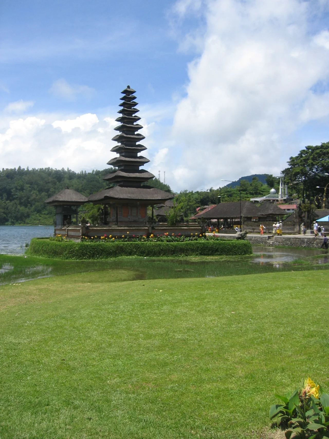
Three Lakes, Three Worlds
Lake Bratan is the largest and most visited of the three caldera lakes, its shores home to the iconic Pura Ulun Danu Bratan temple. The lake sits at approximately 1,231 meters elevation and serves as a critical source of irrigation water for the rice terraces that cascade down the southern slopes of Bali's central highlands through the subak system -- the ancient cooperative irrigation network recognized by UNESCO. Lake Buyan, the largest by surface area, lies to the northwest, surrounded by dense tropical forest and considerably quieter than its famous neighbor. Lake Tamblingan, the smallest and most remote, occupies the caldera's western edge, its shores dotted with ancient temples that predate the more famous complex at Bratan. Together the three lakes form the hydrological heart of central Bali, feeding the rivers and irrigation channels that sustain the island's rice agriculture. What the volcano destroyed in its ancient eruption, water rebuilt.
A Landscape Between Fire and Water
From the air, the Bratan caldera reads as a ring of green ridges enclosing a dark blue archipelago of water. Cloud forest drapes the upper slopes, where moisture from the Indian Ocean condenses against the highlands in a near-permanent mist. The air temperature at this elevation hovers around 20 degrees Celsius -- cool enough to make visitors from the coastal lowlands reach for a jacket, a rare sensation on an island that rarely drops below 27 degrees at sea level. Strawberry farms and flower gardens have replaced jungle on some of the caldera's gentler slopes, taking advantage of the cooler climate. The five post-caldera cones break the rim's symmetry, their peaks rising above the lake surfaces like sentinels. Geomorphological studies published in 2017 classified these cones by shape and composition, revealing a complex eruptive history that produced everything from blocky lava domes to cinder cones. Each one represents a chapter in the caldera's ongoing geological story -- a story whose next chapter remains unwritten.
From the Air
Located at 8.28S, 115.13E in the central highlands of northern Bali, Indonesia. The caldera complex is visible from cruising altitude as a ring of forested ridges enclosing three distinct lakes. Ngurah Rai International Airport (WADD) lies approximately 30nm to the south on Bali's southern coast. From 5,000-8,000 feet AGL, the three caldera lakes -- Bratan, Buyan, and Tamblingan -- are clearly distinguishable, with the temple complex of Pura Ulun Danu Bratan visible on the western shore of Lake Bratan. The caldera sits between the larger volcanic peaks of Mount Agung (east) and the Batur caldera (northeast).
Nearby Stories
- The Rice Goddess and the Dutchmen with Strings 0.4 km away
- Land in the Sea 5.6 km away
- Alas Purwo: Where Java Begins and the Surf Never Stops 18 km away
- When the Ground Moved at Dawn: Bali's 1979 Earthquake 18 km away
- The Tiger's Last Stand: West Bali National Park 25 km away
- Java's Little Africa 39 km away
- Lombok 72 km away
- Forty-Five Men and Thirty-Six Depth Charges 92 km away