Sonian Forest
Step off the tram at Bosvoorde on a weekday morning and within a hundred metres the noise of Brussels falls away as completely as if someone had closed a heavy door. The Sonian Forest begins almost without warning at the city's southern edge, and once you are inside it, the trees do most of the work. They are beech, mostly - tall, smooth-trunked, packed close enough that their crowns lock together a hundred and twenty feet overhead. The light filtering down is green, and the air is cool even in August. UNESCO inscribed parts of this forest as a World Heritage Site in 2017 because some of these beeches were saplings when Napoleon marched his army past on the way to Waterloo, twenty kilometres south, and a few of them, in the Joseph Zwaenepoel reserve, were already old then.
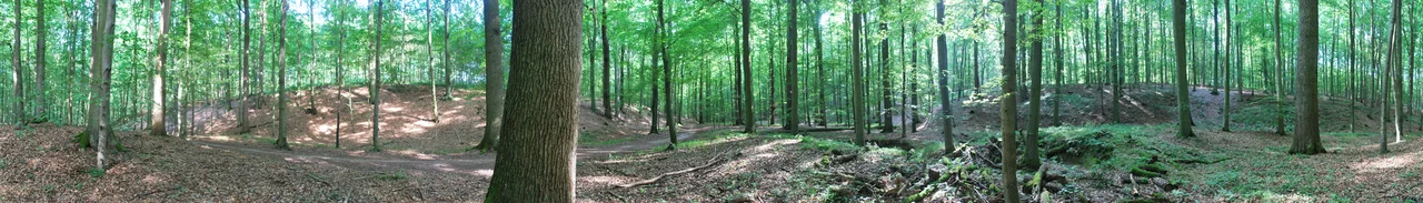
A Cathedral of Trees
The Sonian gets called a "beech cathedral," and the comparison is fairer than most cliches. The trees grow tall and almost branchless for the lower thirty metres, their pale grey trunks rising like pillars, and the canopy closes overhead the way a ribbed vault does. The forest covers about 4,400 hectares - more than five thousand football pitches - and roughly three quarters of it is dominated by European beech. The species was favoured by the Habsburg Dukes of Brabant, who managed the forest as a hunting reserve from the late Middle Ages onward, and successive owners encouraged beech over the original mixed oak. The result is one of the most unusually uniform old-growth stands in western Europe, and a habitat for stag beetles, black woodpeckers, and the elusive European pine marten.
Where the Dukes Rode
For five hundred years the Sonian belonged to whoever ruled Brabant. The Dukes hunted here; the Habsburgs hunted here; Napoleon's foresters logged it for ship timber and for the carriage of guns. The forest was reduced from perhaps eleven thousand hectares in the eighteenth century to its present size, much of the lost ground sold off to pay debts after the Battle of Waterloo. What remains is criss-crossed by old hunting allees - dead-straight rides cut through the trees so that mounted parties could see deer break cover - and dotted with traces of older things still. The Pelouse des Anglais, a small clearing in the forest, is one of the spots from which British troops watched the battle. Iron Age burial mounds, some of the oldest archaeological remains in Belgium, sit hidden among the leaf litter, invisible until you almost trip over them.
Three Highways, One Forest
The forest is not unbroken. Three major motorways - the N275, the R0 Brussels ring, and the E411 to Luxembourg - cut through it, and on a weekday rush hour the roar of traffic carries surprisingly far into the trees. The roads are deadly to wildlife: tens of thousands of frogs, badgers, and deer have died on them over the decades. Belgium has been building ecoducts, green bridges planted with native vegetation, to let animals cross safely. The first, at Groenendaal, opened in 2018, and a second is planned. Stand on one of these bridges at dusk and you can sometimes hear the rustle of a deer making the crossing while, beneath you, three lanes of headlights stream toward Brussels.
Ter Kameren, the City's Front Garden
At the forest's north-western corner, the Sonian thins out and becomes the Bois de la Cambre, or Ter Kameren in Dutch - a hundred and twenty hectares of landscaped park that the city pushed into the woodland in the 1860s. The straight ducal allees give way to winding paths, an artificial lake with an island reachable by a chain-pulled wooden ferry, and the Chalet Robinson, a Swiss-style restaurant rebuilt after a fire in 1991. On a sunny Sunday the Bois fills with Bruxellois walking dogs, jogging, rollerblading on the closed-off Avenue de Diane, and napping under the old beeches. It is the place where the city meets the wild and softens it into something that the city can love.
When to Go
April brings carpets of wood anemone, low white stars that flood the forest floor between the beech trunks. In May the bluebells arrive - in the neighbouring Hallerbos, twenty kilometres south, they create the famous Blauwe Bos that draws photographers from across Europe; in the Sonian they are quieter but no less beautiful. Autumn is the long, golden season: the beech leaves turn copper in October and hang on for weeks, and the forest floor crunches underfoot. Winter strips everything back to grey trunks and bare branches, and on a still morning after fresh snow you can stand in the heart of the forest and hear nothing at all - no traffic, no birds, no wind. It is then that the forest most resembles what the Dukes saw, eight hundred years ago, when this was their hunting ground at the edge of a much smaller city.
From the Air
The forest extends from approximately 50.81 N, 4.39 E to 50.74 N, 4.46 E, hugging the south-eastern edge of Brussels. From cruising altitude the Sonian shows as a dark, almost rectangular block of unbroken canopy on the southern side of the city, sharply bounded by the R0 ring road and the suburbs of Watermael-Boitsfort and Tervuren. Recommended viewing altitude 2,000-4,000 ft AGL to make out the straight ducal allees that cross the forest in a star pattern. Brussels Airport (EBBR) lies 10 km north; the forest sits directly beneath the approach for runway 25L on busy days. In autumn the canopy turns a striking coppery gold that contrasts with the grey city to the north.
Nearby Stories
- Basilica of Our Lady of Scherpenheuvel 4 km away
- Battle of Melle 4.9 km away
- Spanish Fury at Mechelen 6.7 km away
- Marcinelle Mining Disaster 8.4 km away
- Raffinerie Tirlemontoise 10 km away
- Egmont Castle 18 km away
- Courrieres Mine Disaster 69 km away
- Fort Jeanne d'Arc 169 km away