
Bryher
In 1999 a farmer on Bryher was working a field when his plough struck something unexpected: a stone-lined cist grave, two thousand years old, holding a bronze mirror and an iron sword. The burial was rare enough on its own - mirror-and-sword graves are vanishingly uncommon in Iron Age Britain - but in 2023 a new analysis of the deceased's teeth revealed something remarkable. The person buried with the warrior's sword and the lady's mirror was a woman. She is now known simply as Bryher Woman, and her grave is the most striking single discovery on an island of 134 hectares where ancient burial cairns crowd the hilltops and the Atlantic surf hammers a cove called Hell Bay. Bryher is the smallest inhabited island of the Isles of Scilly, with a 2021 population of 177, and it has been telling its visitors stories for at least four thousand years.
A Procession of Hills
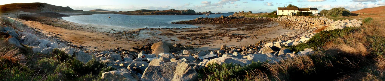
Bryher is two kilometres long and a kilometre wide at its widest point, but it does not feel like a single island. The land is a procession of low granite hills - Gweal, Timmy's, Watch, Heathy and Samson Hill - joined to one another by sandy bars and low-lying necks. Watch Hill is the highest point, capped by a small stone shelter that local tradition says was once used by pilot-gig crews looking out for ships in distress. Shipman Head at the northern end rises 42 metres above the sea. If the sea rose just a few metres more, the southern part of Bryher would break into five or six separate islands. The settlement at the Pool, on the west side, is the westernmost in England. At the lowest spring tides it is possible to walk from Bryher across to Tresco and on to uninhabited Samson without getting your feet wet.
Bryher Woman
The grave was discovered by accident in 1999 when a farmer working a field at Hillside Farm hit the cist with a plough. Inside lay a skeleton, accompanied by an iron sword and a polished bronze mirror - an unusual combination of grave goods. Mirrors in Iron Age Britain are almost always associated with female burials; swords almost always with male. For two decades archaeologists assumed the grave reflected an unusual status for an individual man. Then in 2023, a study by the University of Huddersfield, the University of York and Historic England used tooth enamel proteins to determine sex from the badly degraded skeletal remains. The result was unambiguous: the person buried at Bryher around 100 BC was a woman in her twenties. The find changed the way researchers think about gender and warfare in late Iron Age Britain - and gave the island another reason to remember itself as somewhere stranger than its size suggests.
Cairnfields and Beaker Pottery
Shipman Head, the headland at the northern tip of the island, holds a cairnfield of over 130 burial cairns dating to the early Bronze Age - one of the densest concentrations of prehistoric monuments anywhere in Britain. Most are flat platform cairns laid out in deliberate patterns; a few are chambered, though they do not appear to have been mausoleums in the conventional sense. Archaeologists now think they served as monuments for events connecting the living and the dead rather than as final resting places. A shard of pottery found at Bonfire Carn turned out to be Bell Beaker ware, the only Beaker artefact ever discovered anywhere in the Scilly archipelago. The remains of a Bronze Age field system can still be seen in the intertidal zone at Green Bay - low boulder walls visible at low tide, marking out fields that drowned when the sea rose around 1,500 BC. The Romans were still describing the Scillies as one large island as late as the fourth century.
Hell Bay
On the northwest coast, immediately south of Shipman Head, the Atlantic strikes a small cove called Hell Bay. The name is not poetic exaggeration. The bay faces the open ocean with no land between it and Newfoundland, and the storms that come in from the west pile onto a rocky shore that has been wrecking ships for centuries. The eighteenth and nineteenth centuries left a steady stream of shipwrecks here, though most vessels broke up further out on the Western Rocks before they could reach the cove. Hell Bay also gives its name to Bryher's only hotel - the Hell Bay Hotel, which is the most westerly hotel in England. The hotel sits a short walk inland behind the storm beach, and on bad days the sea is loud enough to hear from every room. On the calm days of August it is loud enough only to remind you that this corner of the British Isles never quite stops moving.
Sites of Special Scientific Interest
Bryher has three Sites of Special Scientific Interest. Shipman Head and Shipman Down, designated in 1971, cover 40 hectares of the northern part of the island. Here waved maritime heath grows over thin podzolic soils on Hercynian granite, sculpted by salt-laden wind into ankle-height carpets that lean away from the prevailing weather. The Pool of Bryher and Popplestone Bank SSSI protects Great Pool, the only natural brackish lagoon in the whole Scilly archipelago, separated from the sea by a narrow storm beach. The Rushy Bay and Heathy Hill SSSI on the southern part of the island is home to the Dwarf Pansy, Viola kitaibeliana, which grows nowhere else in Great Britain - thousands of the tiny purple-and-yellow flowers appear in May on the bare sand and short turf above the beach. Seven species of seabird breed on Shipman Head, including European Storm Petrel, Razorbill, and the four common gull species.
From the Air
Bryher sits at 49.954 N, 6.356 W, in the western group of the Isles of Scilly, immediately west of Tresco across the Tresco Channel. From the air the island reads as a chain of low green hills connected by sandy bars and beaches, with Shipman Head as the prominent rocky headland at the northern tip. The settlement at the Pool on the west side is the westernmost in England. Nearest airport is St Mary's (EGHE) about 3 nautical miles south. Inter-island launches connect Bryher to St Mary's, Tresco, St Martin's and St Agnes - watch for boat traffic in the Tresco Channel. The whole Scilly archipelago is unmistakable in clear weather: cluster of low green islands ringed by white sand and turquoise shallows, 28 nautical miles southwest of Land's End. Best viewing altitude 1,500 to 3,500 ft AGL.
Nearby Stories
- SS Vigrid 6.2 km away
- SS Georgia (1890) 32 km away
- SS Irma (1905) 35 km away
- 1979 Fastnet Race 45 km away
- Great Wheal Charlotte 53 km away
- SM U-27 55 km away
- Wolfpack Prien 151 km away
- Tower of Hercules 715 km away