
Burghead Fort
It was three times bigger than any other fort in early medieval Scotland. For five centuries, from the 300s into the 800s, Burghead was the place where the Picts gathered their power - a walled citadel on a promontory thrust out into the Moray Firth, walls of stone and timber rising above twelve and a half acres of inner enclosure. Then, in the early 1800s, harbour engineers tore most of it down to build a fishing town. They left almost nothing - except the well, the carved bulls, and a fire festival the locals never quite gave up.
The Lost Capital of Fortriu
The Picts wrote little down, and what they wrote we cannot fully read. Their kingdom of Fortriu was long thought to lie further south, around Stirling or Perth, but in the past few decades archaeologists have shifted the map. Fortriu, the dominant Pictish power of the early historic period, almost certainly centred on Moray - and Burghead was almost certainly its royal seat. Ptolemy's second-century Geography mentions a place called Pinnata Castra somewhere on the north coast, and Burghead is its best candidate. The fort's sheer scale tells the story: anyone who could mobilise the labour to wall this headland was running an entire kingdom from it.
Ramparts and the Doorie Hill
Imagine standing on the headland in the 700s. A massive walled enclosure, a thousand feet long by six hundred wide, divided in two - a higher citadel to the southwest, a lower outer ward to the northeast. Across the neck of the headland, three great ramparts and ditches eight hundred feet long cut the place off from the mainland. Sections of inner wall still stand almost ten feet high. One battered fragment of the outermost rampart survives under the local name Doorie Hill - a small hummock that doesn't look like much until you realise it has stood there for fifteen hundred years. In 1793, the engineer William Roy published a plan of the fort just before the harbour works began. Most of what we know of the layout comes from his drawing.
The Bulls and the Well
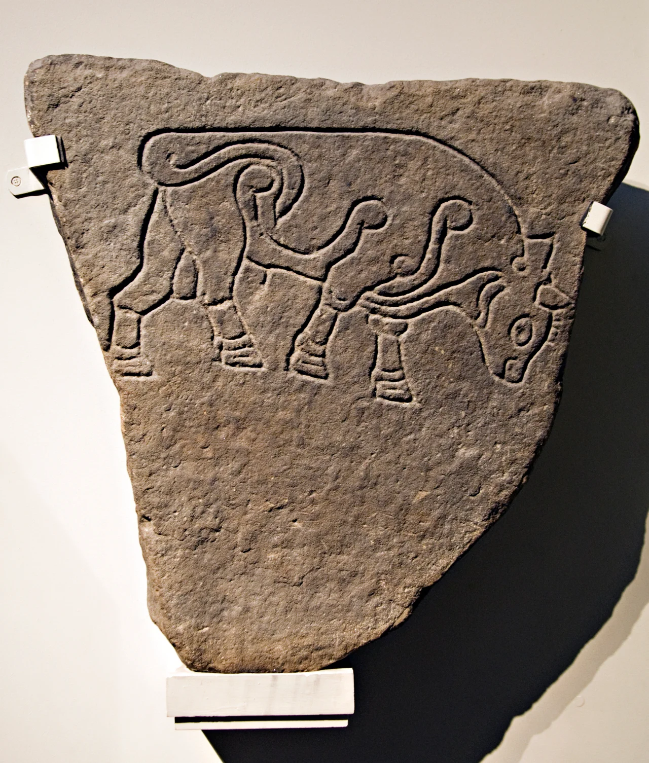
Cut into the headland is a chamber reached by stone steps - a deep ritual well, fed by underground springs, almost certainly Pictish in origin. A Celtic stone head was pulled from it in the nineteenth century. And then there are the Burghead Bulls: at least thirty stone slabs carved with the image of a single bull, in a style so naturalistic that nothing else in early medieval art quite matches it. Six survive today. They may once have formed a frieze running along the ramparts, the emblem of a warrior cult that prized strength and the willingness to fight. Bulls and walls, water and fire - the iconography of a kingdom that was militarily formidable and ritually serious.
The Clavie Still Burns
Every 11 January - old New Year by the Julian calendar - the people of Burghead light a tar barrel called the Clavie and carry it flaming through the streets. The procession ends on Doorie Hill, the last fragment of Pictish rampart, where the burning barrel is set alight and pieces of charred wood are carried away for luck. The Burning of the Clavie has run continuously, by local tradition, for as long as anyone can remember. Most historians treat it as a survival of a much older fire festival, the kind that probably blazed on these ramparts when the kings of Fortriu still ruled. Five centuries of stone fortress, two centuries of fishing village, and an annual fire that no one has ever quite let go out.
From the Air
Burghead Fort sits at 57.70 N, 3.50 W, on a sharp triangular promontory thrust out into the south coast of the Moray Firth, about eight miles north-west of Elgin. From the air the headland is unmistakable: a pointed peninsula with the modern town laid out on a grid above the old fort terrace. RAF Lossiemouth (EGQS) is six nautical miles east; Inverness Airport (EGPE) lies 25 nautical miles west. Best viewed at lower altitudes in clear weather - the white edge of the Moray Firth surf curls around the headland, and on very clear days Dunrobin Castle can be seen across the water on the far Sutherland shore.
Nearby Stories
- Cardhu Distillery 1.5 km away
- Clynelish Distillery 1.8 km away
- Hilton of Cadboll Chapel 3.1 km away
- Huntly Castle 3.4 km away
- Findlater Castle 6.3 km away
- Culloden Viaduct 12 km away
- Helmsdale 23 km away
- HMS Exmouth (H02) 39 km away