
Burns Bog
During the Second World War, more than 100,000 bales of peat were shipped from a wetland south of Vancouver to Las Vegas, where the United States government used the material to help catalyze the manufacture of firebombs. It is a strange fact to carry onto the same ground now, standing in the quiet with sandhill cranes somewhere out of sight. Burns Bog covers about 3,500 hectares of the Fraser delta in Delta, British Columbia — the largest raised peat bog and the largest undeveloped urban landmass on the West Coast of the Americas. Highways bracket it. A municipal landfill presses against one flank. From a few thousand feet up it reads as a flat green absence where a suburb ought to be, and that absence is doing an enormous amount of work.
Ten Thousand Years of Almost Nothing
The bog began forming as the last ice age released its grip on the delta roughly 10,000 years ago. What started as a depression fed by floodwater and groundwater slowly built up organic matter until its surface lifted clear of the water table beneath it. After that, only rain reached it. Ombrotrophic is the technical word — cloud-fed. The water that results is nutrient-poor, acidic and cold, and it suits almost nothing except sphagnum moss, which thrives in it and can hold roughly thirty times its own weight in water. Twelve species of sphagnum grow here. Because that water is acidic and nearly oxygen-free, decay slows almost to a stop, so each year's dead moss compresses beneath the next instead of rotting away. Peat accumulates thickest at the centre, which is why a raised bog domes gently upward: a hill built entirely out of what failed to decompose.
The Cattle That Sank
In 1905 Dominic Burns and his brother bought the bog intending to raise livestock on it, which tells you something about how carefully they had walked it first. The cattle proved too heavy for the ground and sank; some ate plants that poisoned them. The operation moved north, the herd with it, and the failure left behind the only thing that stuck — the name. Industry returned in the 1930s with a clearer sense of what the place was actually good for. Peat came out by the ton for agriculture, for home heating fuel, and for wartime munitions, and by the early 1940s extraction had touched roughly seventy percent of the bog. In the 1950s a company called Western Peat laid sixteen kilometres of railway across the surface to move it faster. Those rails are still out there, settling slowly into the thing they were built to carry away.
Fire That Burns Downward
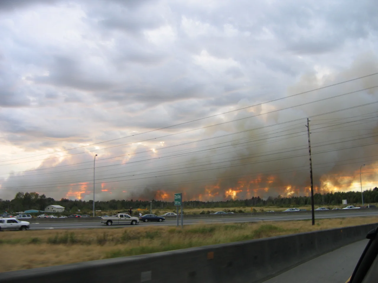
Peat does not burn the way a forest burns. It smoulders below the surface, travelling through dry upper layers where crews cannot see it, and it can outlast a rainstorm that would end an ordinary blaze. In 1996 a bog fire buried Vancouver in smoke and ash for two days, consumed 200 hectares, and cost more than $200,000 to put out. On 11 September 2005 another started near the southeastern edge; within three days it had reached 200 hectares, and the smoke drifted across the Lower Mainland and over the strait as far as Nanaimo. Crews bulldozed firebreaks and raised dikes to flood the ground from below, while the province sent Firecats, Convair 580s, and the Martin Mars flying boats — then the largest water bombers in the world. A third fire, on 3 July 2016, grew to 78 hectares and drew more than a hundred firefighters.
What Seventy-Three Million Dollars Bought
Development proposals first arrived in 1988, and the pushback came from the community around the bog well before it came from any government. A request to designate the bog an ecological reserve was made in 1991 and rejected by most of Delta Council. The Burns Bog Conservation Society kept at it. By 1999 residents had sent hundreds of letters, and the argument had shifted from whether the bog was worth anything to what it would cost to keep. The answer arrived in 2004: $73 million, split among the federal government, the province, Metro Vancouver and the Corporation of Delta, for 2,025 hectares. The following year that land became the Burns Bog Ecological Conservancy Area. On 22 September 2012 the Fraser River delta, Burns Bog included, was listed under the Ramsar Convention as a wetland of international importance — a Pacific Flyway stopover for roughly 250,000 waterfowl and a million shorebirds.
The Edge You Can Walk
Most of the bog is closed, and for sound reasons: the ground is unstable, the sightlines are poor, and public access was never the point of protecting it. The exception is the Delta Nature Reserve, 148 acres at the margin, where a boardwalk built by volunteers more than thirty years ago carries visitors through hardhack meadow and shaded forest into the lagg — the transition zone between the bog and everything pressing in on it. Laggs hold a bog's water table up; without them the dome dries out and dies. Walk it in summer and you find sundew, the bog's small carnivore, and skunk cabbage standing in the wet. Beavers here den in the banks rather than building lodges. The old boardwalk has now reached the end of its life: most trails are closed for hazard-tree removal, replacement construction is anticipated for spring or summer 2026, and one viewpoint remains open.
From the Air
Burns Bog sits at 49.1208°N, 122.9740°W on the south side of the Fraser River's South Arm, within Delta, British Columbia. Best viewed between 2,000 and 4,000 feet AGL, where the bog's flat, olive-green dome stands out clearly against the grid of surrounding farmland and industry. Navigation landmarks: Highway 91 clips the eastern edge, Highway 99 and the Fraser crossing lie to the west, the grey rectangle of the Vancouver Landfill marks the western flank, and Boundary Bay opens to the south. Boundary Bay Airport (CZBB) is roughly 3 nm southwest and generates steady circuit traffic; Vancouver International (CYVR) lies about 9 nm northwest across the river, so expect controlled airspace and heavy arrivals overhead. Pitt Meadows (CYPK) is about 12 nm northeast and Abbotsford (CYXX) about 25 nm east-southeast. Marine fog and low stratus are common from autumn through early spring; the clearest viewing is on summer afternoons, when the North Shore mountains provide a dramatic backdrop to the north.
Nearby Stories
- Mission Raceway Park 1.5 km away
- Gulf Islands National Park Reserve 4.1 km away
- Strait of Georgia 6.7 km away
- Lake Whatcom 15 km away
- Valdes Island 20 km away
- St. Augustine's Indian Residential School 27 km away
- Lower Mainland 30 km away
- Okanagan 193 km away