
Caer Leb
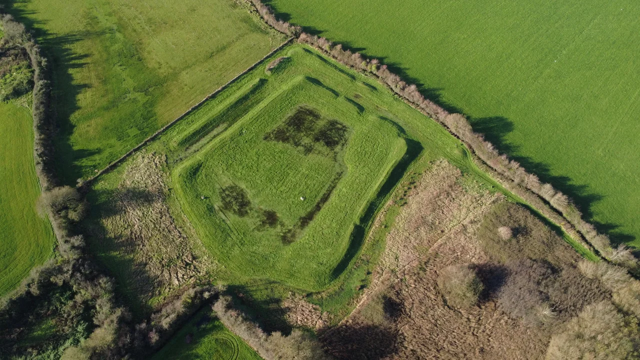
Pull off the A4080 west of Brynsiencyn, park in a layby that holds maybe five cars, and walk through a gate into a wet field. What looks at first like an irregularity in the grass turns out to be a five-sided earthwork, with two parallel banks separated by a boggy ditch and a single original entrance on the east side. This is Caer Leb. The name means 'Leaven Castle' in Welsh - leaven as in the rising agent in bread, possibly a reference to the way the earth banks swell out of the flat ground around them. It has been a working farmstead for more than two thousand years.
Older Than the Romans
The original date of Caer Leb is uncertain because nobody has dug a deep enough trench to settle it. Based on excavations of similar enclosures elsewhere on Anglesey, the consensus is that it was raised around the 2nd century BC - solidly in the Iron Age, more than a hundred years before the Romans arrived in Britain. By that point the island was already densely settled by farmers and small chieftains. The double bank and ditch were probably designed less as a serious fortification than as a status statement, a way of saying that the people inside mattered enough to mark the boundary of their world. Defending such a low-lying site against any determined attack would have been almost impossible. The marsh around it does some of the work; the geometry does the rest.
The 1865 Dig
The first proper excavation came in 1865, when antiquaries found rectangular buildings inside the enclosure on the eastern side and a circular structure on the south. None of these survive above ground today; the foundations are buried or were cleared by later ploughing. The diggers turned up pottery dating from the 2nd century AD all the way to the 4th century - the full span of the Roman occupation of Britain. On the north side, under a layer of peat, they found a layer of periwinkle shells together with a single medieval coin. The shells suggest people were eating shellfish from the Menai Strait, two miles to the north, and bringing the empty husks home. The coin tells you that someone was still moving through the site centuries after the Romans had left.
The Walk to the Stones
Caer Leb sits at one end of a quiet stretch of walking country that strings together several of Anglesey's most important prehistoric sites. A footpath leads south-west from the earthwork along a low ridge above the Afon Braint, passing the cleared site of the lost Tre'r Dryw Bach stone circle and continuing eight hundred metres to Castell Bryn Gwyn. From there it carries on to the Bryn Gwyn Stones and finally meets the A4080 again. The whole walk takes perhaps an hour. In that hour you cross probably four thousand years of human occupation - Neolithic stone circle, Iron Age enclosure, Iron Age fort, late medieval farm. The Anglesey heritage trails are quietly comprehensive, even when the visible remains are slight.
What the Field Loses
Five hundred metres north-west along the road, near a small bridge called Pont Sarn Las - the Green Causeway Bridge - the foundations of three round houses occasionally appear after a dry summer, when the grass burns off the slightly raised stone footings. A much larger settlement was recorded here in the nineteenth century but was destroyed in the 1870s by agricultural improvement, that polite Victorian phrase for the systematic levelling of ancient earthworks to gain a few extra furrows of arable land. Caer Leb survived because its banks were too steep to plough cheaply and too well-known to bulldoze openly. Other sites along the same stretch of road simply vanished. Anglesey's prehistoric landscape is what got missed, not what was preserved.
From the Air
Caer Leb sits at 53.18 degrees north, 4.29 degrees west on south-eastern Anglesey, in low-lying farmland west of Brynsiencyn and about two miles from the Menai Strait. The low double-banked enclosure is hard to spot from the air but the field pattern is distinctive. Best viewed at 1,500-2,500 feet. Caernarfon Airport (EGCK) lies five nautical miles south-east; RAF Valley (EGOV) is 13 miles west - watch for fast-jet activity and the Valley MATZ.
Nearby Stories
- Wakestock 1.7 km away
- Trefriw 3.8 km away
- Irish Sea 8.7 km away
- Irish Sea Bridge 20 km away
- East–West Interconnector 30 km away
- Machynlleth 36 km away
- HMS Tyler 41 km away
- New Brighton Lifeboat Station 54 km away