
Cahersiveen
Daniel O'Connell was born just outside this town in 1775, and his town has not stopped acknowledging him since. The Catholic church on Main Street, built between 1888 and 1902, is one of the very few Catholic churches in the world dedicated to a layperson - to him. A memorial in the church grounds faces his birthplace at Carhan. The Liberator's hometown is now a working market town of about 1,300 people, sitting under a sky so unpolluted by artificial light that it has been formally recognized as one of only four Gold Tier Dark-Sky Reserves on Earth. The town's history runs from medieval estate to nineteenth-century garrison to twenty-first-century stargazing destination, with O'Connell quietly presiding over the whole sequence.
The Liberator's Country
Daniel O'Connell - lawyer, member of parliament, and the political leader of Ireland's Catholic majority through the first half of the nineteenth century - is the historical figure who shaped this corner of Kerry more than any other. His successful campaign for Catholic Emancipation, which became law in 1829, transformed the legal position of Catholics across the United Kingdom. He drew his political legitimacy from mass meetings of ordinary Irish people, and the Iveragh Peninsula was his home country. The O'Connells of Carhan were a Gaelic Catholic family who had managed, through the network of cousinly relationships that organized Catholic Munster, to hold onto land through the worst of the Penal Laws. Daniel was born into that survival. The town that grew up here became, in his own lifetime and after, a kind of secular shrine to him. The dedication of the Daniel O'Connell Memorial Church a generation after his death formalized what had already been local feeling for decades.
The Barracks That Looks Like a Bavarian Castle
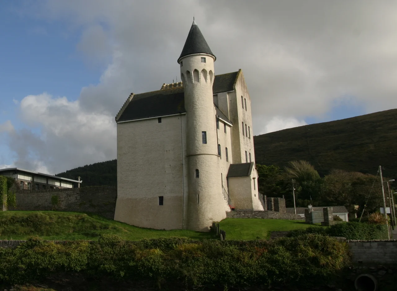
Halfway down Main Street stands a building that the architect, Enoch Trevor Owen, designed in what is generally called Schloss style - turrets, gables, and an oddly Mitteleuropean profile that does not at all resemble the rest of Victorian Cahersiveen. It was built in the 1870s as a Royal Irish Constabulary barracks and served as such until the force was disbanded in 1922. A persistent myth holds that the building was constructed from plans intended for India and sent to Ireland by mistake - a story heard about more than one Irish garrison town. It is almost certainly not true; the same architect designed multiple barracks in a similar style across Ireland. What is true is that the building is now a heritage center, that it is one of the most photographed structures in west Kerry, and that the contrast between its picture-book turrets and the workaday Victorian buildings around it is one of the small visual surprises of the Ring of Kerry.
Roads, Rails, and the Bog Commission
Cahersiveen sits at the end of a remarkably modern road - the N70, a national secondary route that is the direct descendant of a road built in 1822 by the Scottish civil engineer Alexander Nimmo. Nimmo arrived in 1811 as a representative of the Bog Commission and found the area inaccessible by carriage; over the following decade he designed roads and bridges that finally connected this part of the Iveragh Peninsula to the rest of the country. From 1893 to 1960, the Great Southern and Western Railway also ran a branch line out to Cahersiveen, dropping passengers and goods at a station that closed when the rural lines were rationalized. The infrastructure left behind by all this is now mostly the road. Buses run through; the trains do not. The branch line is largely a memory and a few stretches of trackbed.
Dark Sky, Gaeltacht, and Forts in the Hills
In 2014, the Kerry International Dark-Sky Reserve became the first Gold Tier Reserve in the northern hemisphere and one of only four Gold Tier sites in the world - a recognition of how little light pollution this part of Kerry produces and how well the local community has agreed to keep it that way. Cahersiveen sits inside it. On a clear winter night, the visibility of the Milky Way from the edge of town is, in technical terms, a Bortle 2 - which is to say, as good as it gets in inhabited Europe. In 2023, the town was also designated a Gaeltacht Service Town, a recognition of its role supporting the Irish-speaking communities around it. The surrounding hills hold Cahergall and Leacanabuile, two well-preserved circular stone forts from the late iron age and early medieval period, along with Ballycarbery Castle just down the road. The town has been a service center for this landscape for a very long time. What has changed, mostly, is what people come here to be served by - markets, then garrisons, then schools, and now, increasingly, the night sky.
From the Air
Located at 51.948°N, 10.224°W on the Iveragh Peninsula, at the head of Valentia Harbour. Recommended viewing altitude 2,000-3,500 feet AGL. The town sits between Cahergall and Leacanabuile stone forts and Ballycarbery Castle to the west (all within 4 km) - a useful cluster of waypoints. Valentia Island and Beginish Island lie to the west; Dingle Bay opens to the north. Nearest airport is Kerry (EIKY), about 30 nm northeast; Valentia has a small grass strip (EIVT) about 5 nm west. The N70 runs through town as a useful linear reference. Cahersiveen is the center of the Kerry International Dark-Sky Reserve - excellent for night flying photography but watch for very dark uninhabited terrain in the surrounding hills.
Nearby Stories
- 1955 RAF Shackleton aircraft disappearance 3.8 km away
- Ballynavenooragh 5.4 km away
- French Expedition to Ireland (1796) 9.4 km away
- Tralee 12 km away
- Uragh Stone Circle 18 km away
- The Laki Eruption: The Volcano That Changed World History 1385 km away
- The Northern Lights: The Sky Show That Vikings Thought Was Bridge to the Gods 1487 km away
- Sao Miguel 1921 km away