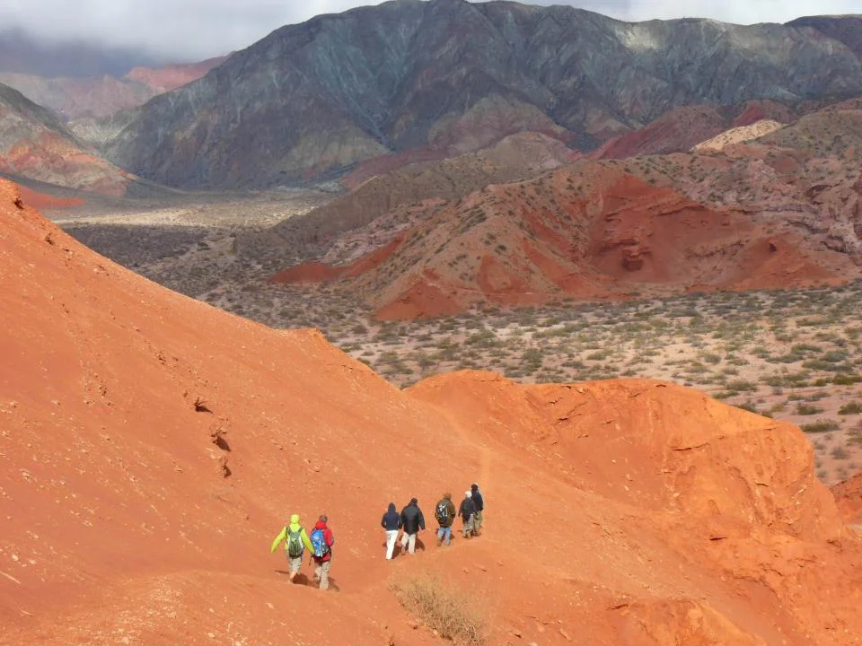

Calchaquí Valley
It took the Spanish empire more than a hundred years to subdue these valleys, and even then the victory came at the cost of the people themselves. When conquistadors toppled the Inca in the 1530s, Inca control of the region had already collapsed by 1543, but the Indigenous peoples of the Calchaquí Valleys kept fighting the newcomers until 1650. They had reason to defend it. Stretching north to south across the provinces of Catamarca, Tucumán, Jujuy, and Salta, the Calchaquí Valley is one of the most extraordinary landscapes in Argentina, a place where the land shifts from mountain desert to subtropical forest and the rock itself bleeds color.
A Valley Dropped Between Giants
The Calchaquí Valley is a graben, a long block of the earth's crust that sank between two parallel faults, leaving mountains towering on either side. To the east rise the Sierra del Aconquija and the Cumbres Calchaquíes, cresting above 4,170 meters; to the west, the Sierra de Quilmes climbs higher still, past 5,460 meters. These ranges belong to the Sierras Pampeanas, the spine of mountains that runs through northwestern Argentina just east of the Andes proper. Down the trench between them flows the Calchaquí River, gathering tributaries and lending its name to a whole network of smaller valleys, each with its own character: the Gorge of the Bull, the Enchanted Valley at the foot of the Bishop's Slope, the Lerma Valley near the city of Salta. It is less a single valley than a system, a branching world held inside a crack in the continent.
The Stone Remembers Water
Near Cafayate, the Quebrada de las Conchas tells the valley's deepest secret: this desert was once underwater. The reddish sandstone amphitheaters and gorges were carved by rushing water in ages when the climate was humid, and the rock today preserves a staggering fossil record. There are layers of marine and continental limestone, the footprints of dinosaurs, fossil frogs near the Morales bridge, and stromatolites, the fossilized mats of some of the oldest life on Earth. At a site called the Yesera, a rich deposit of fossil fish marks an astonishing event from roughly fifteen million years ago: the last time the sea reached this far inland. The water that shaped these cliffs is long gone, but it left its signature pressed into every layer of stone.
Cathedrals of Red Rock
National Route 68 runs through the Quebrada de las Conchas along the Conchas River, and the drive is a procession of natural sculptures with names that sound borrowed from a fable. There is the Garganta del Diablo, the Devil's Throat, and the Amphitheater, a vast curved hollow in the rock with acoustics that turn a whisper into something vast. There is the Friar, the Toad, the Windows, the Castles, each a formation eroded into uncanny resemblance. Seven kilometers from Cafayate lie Los Médanos, drifts of fine pale sand deposited by wind. The colors shift constantly, reds deepening to crimson, ochres paling to gold, as the sun moves across walls that astonish precisely because they were built by absence: by everything the water and wind carried away.
The Road of the Inca, the Refuge of Birds
History is not buried here so much as barely covered. Recent archaeological work found that the ancient Inca road once ran just meters from the modern Route 68, two highways from two empires laid almost atop each other across the same valley floor. The peoples who resisted Spain so long left their mark in fortified hilltops and scattered ruins throughout the region. And the valley remains alive in the present tense: its creeks and surroundings are recognized as one of Argentina's Important Bird Areas, a sanctuary woven through the dramatic geology. From mountain desert to humid yungas forest, from dinosaur tracks to a living road network, the Calchaquí Valley layers time on time, inviting travelers to read a landscape that has never stopped being written.
From the Air
The Calchaquí Valley runs north-south across northwestern Argentina, with this central reference point near 26.45°S, 65.98°W, spanning parts of Catamarca, Tucumán, Jujuy, and Salta provinces. Valley floors sit largely between 1,600 and 2,500 meters, flanked by the Cumbres Calchaquíes (4,177 m) to the east and Sierra de Quilmes (5,468 m) to the west. The principal gateway airport is Martín Miguel de Güemes International at Salta (ICAO SASA / IATA SLA); Cafayate, near the valley's famous Quebrada de las Conchas, has a small local aerodrome, and National Routes 68 and 40 trace the valley corridor. From the air, look for the long rift between high parallel ranges, the vivid red and ochre sedimentary gorges near Cafayate, and the abrupt transition from green montane forest in the east to bare desert in the rain shadow. Clear, dry conditions prevail outside the summer rainy season, offering expansive views of the valley system.
Nearby Stories
- Cafayate 15 km away
- Congress of Tucumán 20 km away
- Tafi del Valle 29 km away
- San Miguel de Tucuman 44 km away
- 1692 Salta Earthquake 106 km away
- Londres, Catamarca 129 km away
- Tolar Grande 202 km away
- Ojos del Salado 221 km away