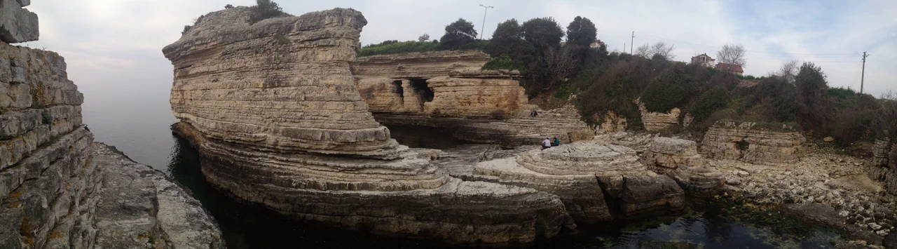

Calpe (Bithynia)
In the spring of 400 BC, roughly ten thousand Greek mercenaries stood on a promontory on the Black Sea coast and looked at a harbor that might have become a city. They had survived the Persian interior, the mountains of Armenia, the hostile Caucasian tribes, the long cold march toward the sea. They had reached it — the Black Sea, which they called the Pontus Euxinus, the Hospitable Sea — and here at Calpe, halfway between Byzantium and Heraclea Pontica, they rested. Xenophon, who led them and wrote down what happened, described the place in such precise detail that modern scholars can still find it: the narrow neck of land only 400 feet wide, the cliff falling straight to the sea, the port sheltered under the rock to the west, the fresh water source close to the beach. He saw it as a potential colony. His soldiers voted otherwise. They kept walking.
What Xenophon Saw
The description in Xenophon's Anabasis is unusually specific for ancient geographic writing. The promontory at Calpe, he noted, projects into the sea and ends in an abrupt precipice — a cliff that makes the seaward end essentially unassailable. The neck connecting this headland to the mainland is only about 400 feet wide, making the whole promontory something close to a natural fortress. The port lies to the west, sheltered by the rock above it. Fresh water springs from the ground near the beach. Timber grows in the hills immediately behind. Wood, water, a defensible site, a harbor: Xenophon ticked off the qualities of a viable settlement and concluded, explicitly, that this would be a good place to build a city. The site near the modern village of Kerpe, where ancient Calpe is generally located, still shows the coastal topography Xenophon described — the headland, the narrow neck, the sheltered bay to one side.
The Ten Thousand Who Almost Settled Here
The men Xenophon led were not explorers or colonists by original intent. They were Greek mercenaries hired by the Persian prince Cyrus the Younger to help him seize the throne from his brother Artaxerxes II. Cyrus died in battle at Cunaxa in 401 BC, their Persian employers dissolved, and the Greeks found themselves stranded thousands of miles inside enemy territory without a patron or a plan. What followed — the long march north and west toward the Black Sea, fighting through hostile territory the entire way — became one of the most dramatic collective survival stories in antiquity. When they finally reached the sea at Trapezus (modern Trabzon), the men wept and embraced each other. Calpe came later, after they had turned west along the coast, still hungry and still fighting. By the time they reached the promontory, the debate about building a permanent settlement was real: some of the soldiers were genuinely considering whether to stop marching and start building. Xenophon himself favored the idea. He was outvoted.
Halfway Between Two Worlds
Xenophon places Calpe about halfway between Byzantium and Heraclea Pontica — between the gateway to Europe and the main Greek city of the Pontic coast. That midpoint location gave the harbor a natural logic as a waystation for coastal traffic. Arrian, writing in the second century AD, placed Calpe 210 stadia from the mouth of the Psilis River. Solinus and Stephanus of Byzantium both noted the site. Its ancient name — Calpe or Calpas, shared with the river Calpas, modern Ilaflı Dere, that flows nearby — suggests the toponym predates the Greek presence. The river gave the place its name, or the place gave the river its name; in either case, the connection between water and settlement was the defining fact. Whatever city might have grown here did not; Calpe remained a waypoint rather than a destination, remembered mainly because Xenophon stopped there and wrote it down.
Kerpe and the Quiet Coast
The site of ancient Calpe is today identified with the area near Kerpe, a small coastal settlement in Kocaeli Province on the Black Sea coast of Turkey. The modern village carries none of the weight of the ancient description — it is a quiet stretch of coastline, fishing boats, a beach, the forested hills of the Kocaeli Peninsula rising behind it. The dramatic promontory that Xenophon found so promising is still recognizable in the coastal geography, though the harbor has long since changed in use and character. Calpe exists now primarily as an archaeological and literary location rather than a living one: a place where scholars look at cliffs and measure necks of land against a two-thousand-year-old text, trying to confirm what they already believe — that the exhausted Greek soldiers stood exactly here, looked at exactly this view, and debated a future they ultimately walked away from.
From the Air
Ancient Calpe lies near modern Kerpe at approximately 41.16°N, 30.20°E on the Black Sea coast of Kocaeli Province. At 2,000–4,000 feet, the headland topography that Xenophon described remains visible: the promontory projecting into the sea, the narrow land connection to the mainland, the sheltered bay on the western side. The Ilaflı Dere (ancient Calpas River) is identifiable where it meets the coast. The forested hills of the Kocaeli Peninsula rise to the south. Nearest major airport: LTFJ (Sabiha Gökçen International), approximately 95 km to the west-southwest. The Black Sea coast here is lightly developed; approach from the north offers the clearest view of the headland's distinctive shape. Best visibility in afternoon after morning coastal haze clears.
Nearby Stories
- Battle of Mount Scorobas 12 km away
- 2015 Sabiha Gökçen Airport Bombing 20 km away
- 1965 Hendek Bus Accident 22 km away
- Tottenham (1802 Indiaman) 26 km away
- Polonezköy 29 km away
- Sangarius Bridge 36 km away
- Januarius MacGahan 61 km away
- Battle of Constantinople (922) 79 km away