.jpg)
Sangarius Bridge
Procopius wrote that men used to die crossing here. The wooden pontoon bridge that spanned the Sakarya kept getting washed away when the river flooded, and each replacement was thrown together quickly enough to fail again. So when Justinian finally ordered a permanent stone crossing in the 550s, it was not a vanity project. It was a piece of imperial infrastructure designed to keep his soldiers, his couriers, and his tax collectors moving between Constantinople and the eastern provinces without losing them to the spring melt.
Why It Was Built
The Sakarya River, which the Greeks called the Sangarios, drains a substantial chunk of northwestern Anatolia. Its lower course winds through Bithynia, the old Roman province that sat directly between the imperial capital and the entire Asian half of the empire. Anyone moving an army from Constantinople toward the Persian frontier had to deal with this water, and Justinian was constantly moving armies. His reign was a long war on three fronts: against the Sasanian Persians in the east, against the Vandals in North Africa, and against the Ostrogoths in Italy. The Persian campaigns alone consumed enormous quantities of men and supplies, and every season's military timetable depended on rivers being crossable. Procopius, writing his treatise De Aedificiis on Justinian's building projects, described the bridge while it was still under construction. Two laudatory poems by Paul the Silentiary and the historian Agathias celebrated its completion in 562. The chronicler Theophanes recorded that work had begun in the year 559 or 560. Some scholars now think construction may have actually started as early as 554, with the project taking longer than the surviving inscriptions admit.
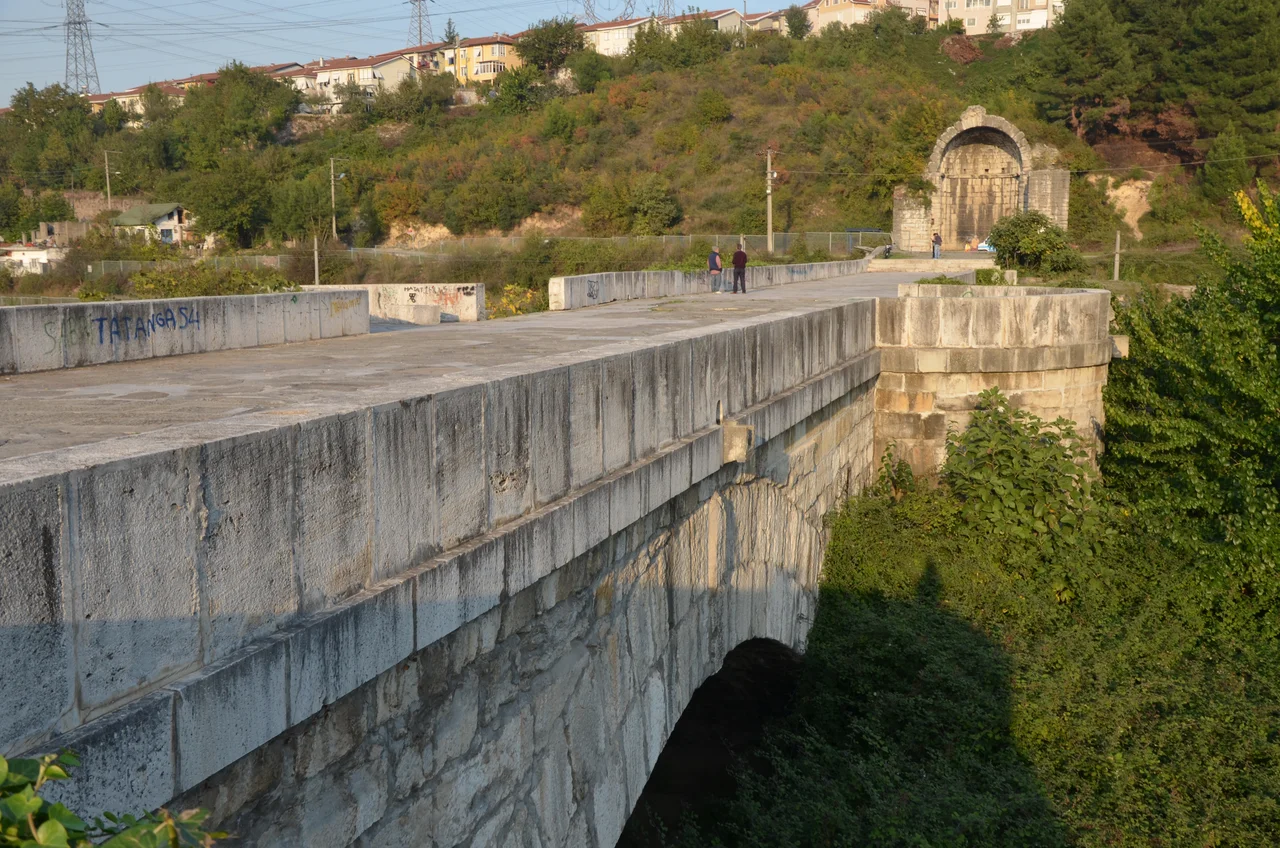
Engineering at Scale
What survives today is impressive on any honest accounting. The bridge runs 429 meters long including its abutments at each end. It stands nearly ten meters wide and rises up to ten meters above what would have been the water level. Seven main arches carry the deck. The five central arches each span between 23 and 24.5 meters, with stone piers about six meters thick between them. A pair of slightly smaller arches, each about 20 meters across, frame the central span. The whole structure is built of limestone blocks set without modern reinforcement, relying entirely on the geometry of the arch and the weight of the masonry to hold itself together. That this is essentially still standing fifteen hundred years later, in a region prone to earthquakes, says something about how seriously the Romans took their engineering. A monumental arched gateway once rose at the bridge's entrance. Léon de Laborde sketched it in 1838. The doorway was 10.37 meters tall and 6.19 meters wide, framed by stone pillars more than four meters thick. That gateway is gone now.
A Canal That Never Was
There is a curious footnote attached to this bridge. Pliny the Younger, governor of Bithynia in the early second century, once wrote to the emperor Trajan suggesting that a canal could be cut to link Lake Sapanca, just upstream, to the Sea of Marmara. Such a canal would have allowed ships to bypass the Bosporus entirely, opening a sheltered inland water route. Trajan was intrigued enough to ask for a survey. Nothing came of it in his lifetime, or in the centuries after. But when Justinian's engineers built the Sangarius Bridge so massively, some modern historians have wondered whether the back of his mind was on Pliny's old idea, whether he was preparing for a navigable channel that never quite happened. The bridge as built was big enough to span a major river. The smaller stream below it today, the Çark Deresi, has nothing to do with what the Romans had in mind. The actual Sakarya now flows three kilometers east of the bridge, having shifted its course over the centuries. The bridge stands marooned on a floodplain, spanning a creek where it once spanned an empire's artery.
Reading the Inscription
Agathias composed a Greek epigram for the bridge that was carved into stone here when it opened. The original inscription has been lost, but its text was preserved by the tenth-century emperor Constantine VII Porphyrogenitus, who copied it into one of his books. The verses praised Justinian's engineering and the river he had tamed. Today the eastern end of the bridge has been damaged by the construction of a railway line that runs along the old river course, slicing through what would have been the original abutment. Even so, what remains is essentially intact: seven great arches stepping across a quiet plain southwest of the modern town of Adapazari, in a country that did not exist when the bridge was built and an empire that no longer exists either.
From the Air
The Sangarius Bridge sits at 40.74N, 30.37E, about five kilometers southwest of central Adapazari in Sakarya Province, Turkey. It is now a riverine landmark at low altitude, hard to spot from cruise. The bridge is best appreciated below 2,000 feet AGL, where the seven-arch profile and 430-meter length stand out clearly against the floodplain. Sapanca Lake glints to the southwest, a useful navigation reference. The closest major airport is Sabiha Gokcen (LTFJ) about 60 nautical miles west on the Asian side of Istanbul. Eskisehir Anadolu (LTBY) lies roughly the same distance south. The Bursa-Istanbul-Ankara corridor passes north of here, with frequent IFR traffic above. Visibility tends to be best in autumn and early winter, when the plain is clear of summer haze.
Nearby Stories
- Ağva 20 km away
- SM UC-13 23 km away
- Hereke 24 km away
- Bursa 73 km away
- 2025 Kartalkaya Hotel Fire 74 km away
- Green Mosque of Bursa 117 km away
- Mevlâna Museum 315 km away
- The Charge of the Light Brigade: The Most Famous Military Blunder in History 450 km away