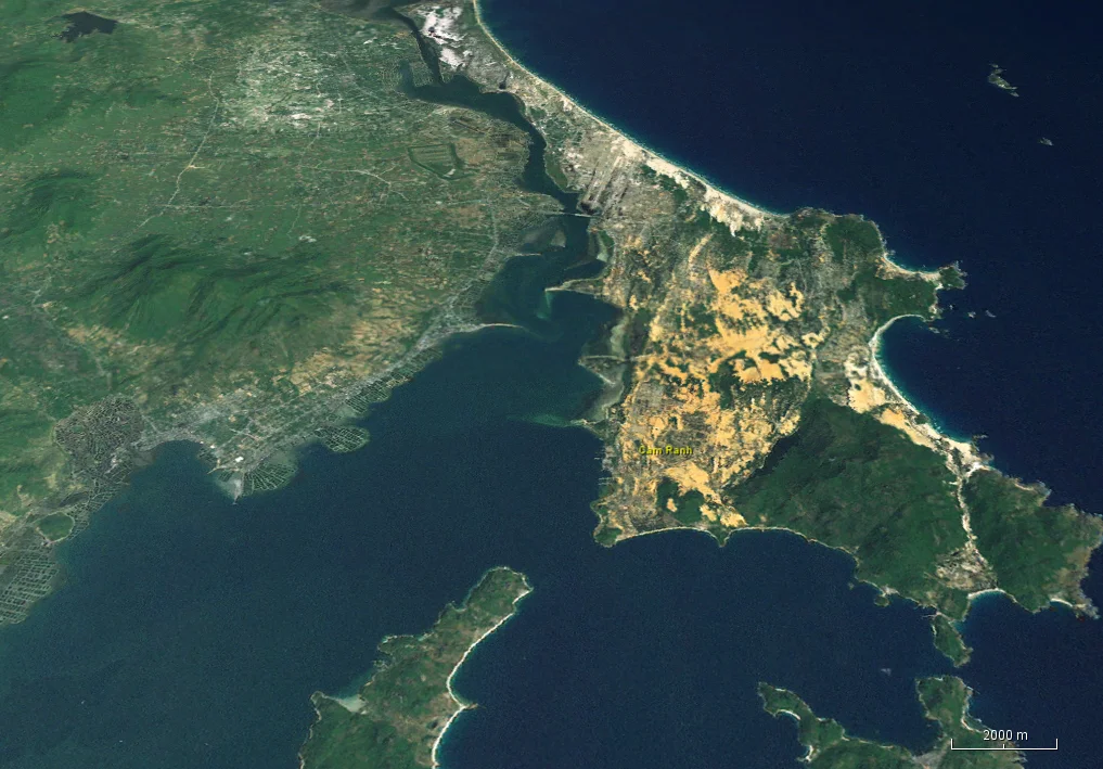

Cam Ranh Bay
In 1905, forty Russian warships anchored in this bay on their way to one of the worst naval defeats in modern history. In 1942, Japanese Imperial Navy vessels staged here before the invasion of British Malaya. During the 1960s and 1970s, it became one of the largest American military installations in Southeast Asia. Then, from 1979 to 2002, the Soviet Pacific Fleet operated from it as its largest base outside the Soviet Union. No single body of water in the region has served so many flags — and for such a simple reason: Cam Ranh Bay is considered the finest deepwater natural harbor in Southeast Asia, a place where the continental shelf runs narrow and the deep water comes close to land.
The Geography of Power
Geography made Cam Ranh Bay strategically inevitable. The bay opens to the South China Sea along the southeastern coast of Vietnam, positioned between Phan Rang to the south and Nha Trang to the north, approximately 290 kilometers northeast of Ho Chi Minh City. The continental shelf narrows sharply here, meaning deep water — enough for the largest warships — lies just offshore. The bay itself offers calm, sheltered anchorage behind a long peninsula, protecting vessels from the open sea swell. These are the conditions that every naval planner in the early 20th century was trained to recognize and exploit. Once one power had used the bay, others noted it. The pattern became self-reinforcing: each flag that flew here made the harbor more developed, more capable, more difficult for the next power to ignore.
Empire and Catastrophe
The French used Cam Ranh as a naval base for their Indochina forces, establishing the infrastructure that later powers would inherit and expand. In May 1905, Admiral Zinovy Rozhestvensky assembled his 40-ship Russian Imperial fleet here before sailing north to face the Japanese at Tsushima — where the Russian navy was annihilated in what remains one of the most decisive sea battles of the modern era. The bay itself was uninvolved in that catastrophe, but it provided the last moment of calm before disaster. Thirty-seven years later, Japanese Imperial Navy vessels staged from Cam Ranh before striking into British Malaya in December 1941. In January 1945, U.S. Naval Task Force 38 struck Cam Ranh Bay in an operation called Gratitude, sinking dozens of Japanese ships and rendering the harbor untenable as a fleet base. The bay was abandoned. It would not stay empty for long.
America's War
The United States began surveying Cam Ranh Bay in 1964. Admiral Harry D. Felt had identified it as strategically valuable, and a 350-foot pier was already under construction when a North Vietnamese trawler was caught landing munitions at nearby Vũng Rô Bay in February 1965 — an incident that accelerated American development of the site. Army engineers of the 35th Engineer Construction Group arrived by LST, built roads through desert sand using red laterite soil and crushed granite, extended the pier to 600 feet, and laid an airstrip in fifty days. By 1970, the Cam Ranh Support Command controlled a port with five piers, an airfield capable of tactical fighter operations, and a logistics complex with an authorized strength of nearly 8,000 personnel. It was one of three aerial ports through which American military personnel entered and departed South Vietnam. On 3 April 1975, North Vietnamese forces captured it all.
The Soviet Years
Four years after the fall of Saigon, the Soviet government signed a 25-year lease with unified Vietnam, turning Cam Ranh Bay into the largest Soviet naval base outside the Soviet Union. The Pacific Fleet expanded the base to four times its original American-era size by 1987, using it to project power across the South China Sea — including, according to U.S. Pacific Fleet intelligence, conducting mock attack runs toward the Philippines. The Soviet and Vietnamese governments officially denied any military presence there, a fiction that was difficult to maintain given the scale of construction. By 1990, concrete reductions had begun; the Soviet Union was unraveling. Vietnam announced in advance that it would not renew the lease when it expired in 2004, and the Russian flag was lowered on 2 May 2002. The reversion was formal and final — or nearly so. In 2016, Russia indicated it was reconsidering the possibility of a return. As of 2024, no such talks have materialized.
A Harbor Reclaimed
Vietnam now uses Cam Ranh as the headquarters of its Navy's 4th Regional Command, its Naval Air Force, and its only submarine base. The harbor that served so many foreign powers serves Vietnamese sovereignty. In 2010, Prime Minister Nguyen Tan Dung announced the bay would reopen to calls by foreign warships — a commercial and diplomatic decision, not a military lease — and U.S. Navy ships made their first port visit since 1975 on 2 October 2016. Ba Ngòi Port, the commercial harbor within the bay, handles international cargo within a few kilometers of the National Highway and the railway. The bay that spent a century as a stage for geopolitics has become, in addition, a working port, a navy base, and a place where fishing boats and submarines share the same sheltered water.
From the Air
Cam Ranh Bay lies at 11.88°N, 109.17°E, clearly visible from altitude as a large sheltered bay on Vietnam's southeastern coast. The distinctive long peninsula forming the bay's eastern arm is a prominent landmark; the bay opening to the South China Sea is visible to the east. Cam Ranh International Airport (VVCR) sits on the peninsula just south of the city, with runways oriented roughly north-south. From 8,000–15,000 feet the bay's size and shelter are apparent — approximately 16 km long. The urban area of Cam Ranh city occupies the western shore. Nha Trang (VVNT) lies approximately 50 km to the north.
Nearby Stories
- Vinpearl Cable Car 10 km away
- Linh Phước Temple 17 km away
- Phan Rang–Tháp Chàm 19 km away
- Bidoup Núi Bà National Park 37 km away
- Operation Byrd 40 km away
- South-East Asian Theatre of World War II 181 km away
- Kashmir Princess 361 km away
- Battle of the Paracel Islands 529 km away