Camp Cady
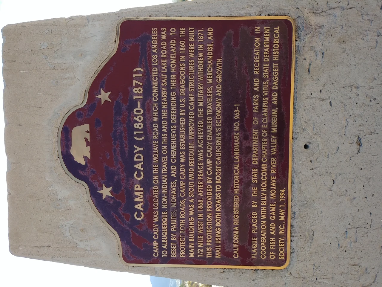
The Mojave Road existed before the Army did — a desert corridor used by Indigenous peoples for centuries before Spanish missionaries, fur trappers, and forty-niners found it. When the U.S. Army finally showed up in 1860, it built Camp Cady to guard a specific point along that road: the Mojave River crossing near what soldiers called Bitter Spring. Water was the whole point. In the Mojave Desert, whoever controlled the water holes controlled movement, and movement mattered when the Army was trying to keep a tenuous peace between settlers and the Paiute people who had lived here far longer than anyone in Washington had.
The Road That Needed Guarding
The Mojave Road was more than a trail — it was the southern overland route connecting the Colorado River to the Pacific Coast, running through one of the driest stretches of North American desert. Soldiers, mail riders, and emigrant wagons all depended on water holes spaced far enough apart to make each one critical. Camp Cady, established in 1860 under Major James Henry Carleton, sat at one of these critical points on the Mojave River.
Carleton's Bitter Spring Expedition gave the camp its early purpose: scouting the road, mapping water sources, and establishing a military presence that might deter conflict. The location was practical rather than comfortable. Temperatures in the Mojave summer regularly exceeded 110 degrees, the river ran underground for long stretches, and the nearest anything was far away.
The Paiute Conflict
The peace that Camp Cady was meant to maintain proved difficult. The Paiute people, whose territory encompassed this part of the Mojave, had their own relationship to the road and its resources — a relationship that predated American emigration and didn't accommodate it comfortably. Tensions escalated into raids and reprisals, and Camp Cady found itself less a peacekeeping outpost and more an active military installation.
The first incarnation of the camp closed in 1861, when the Civil War pulled soldiers and resources elsewhere. The Army returned in 1866 and kept the post active until 1871, when the worst of the conflicts had subsided and the strategic logic of maintaining a garrison in this particular piece of desert no longer seemed compelling. The soldiers left, and the Mojave reclaimed the ground with its usual efficiency.
What the State Remembered
For most of the century that followed, Camp Cady existed mainly in military records and the occasional historical account of the Mojave Road. Then, in the 1960s, California's historical preservation machinery caught up with it. The site was designated California Historical Landmark Number 963 — an official acknowledgment that what happened here, however forgotten, was worth marking.
The landmark designation arrived long after anything physical remained of the camp itself. The Mojave has little patience for wooden structures and canvas tents. What survived was the landscape — the river bottom, the road corridor, the same brutal geometry of heat and distance that made water holes worth fighting over in the first place. The land that surrounded the camp became the Camp Cady Wildlife Area, managed for desert habitat rather than military purposes, a quieter use of ground that was never particularly quiet.
The Desert Endures
The Mojave Road still exists as a rough four-wheel-drive route, maintained by volunteers and used by off-road enthusiasts who trace the same corridor that soldiers, missionaries, and emigrants once followed. Camp Cady's location on that road gives it a kind of archaeological resonance — you can stand where the outpost stood and look down the same sightlines that soldiers watched for movement.
The Camp Cady Wildlife Area surrounding the site protects riparian habitat along the Mojave River, one of the few places in this landscape where cottonwoods and willows grow. Birds stop here during migration. The river, which runs underground through most of its length, surfaces near the old camp — still the same reliable water that made this a strategic point in 1860, now drawing different visitors for different reasons.
From the Air
Located at 34.946°N, 116.589°W along the Mojave River in San Bernardino County. The camp site sits within the Camp Cady Wildlife Area, visible as a riparian green strip against the surrounding desert from low altitude. Nearest airport: Barstow-Daggett Airport (DAG), approximately 20 miles southwest.
Nearby Stories
- Mojave Trails National Monument 20 km away
- Granite Mountains (Eastern San Bernardino County) 25 km away
- Giant Rock 36 km away
- The Trona Pinnacles: California's Most Alien Landscape 58 km away
- San Bernardino Train Disaster 60 km away
- Edwards Air Force Base 74 km away
- The 49ers of Death Valley: The Shortcut That Became a Deathtrap 124 km away
- MGM Grand Fire 131 km away