Capitólio
On the afternoon of January 8, 2022, a canyon wall sheared off. Tourists were swimming and drinking beer in the warm green water below, their pleasure boats idled in a rocky inlet called Lagoa de Furnas. A column of stone forty meters high broke at its base, tilted, and fell. Mobile phones caught the collapse from multiple angles - the slow lean of the rock, the screams building, the massive splash that buried three boats and killed ten people. Capitolio, a Brazilian town of roughly 8,600 residents in southwestern Minas Gerais, had become known worldwide for its spectacular canyons. That weekend, the town's identity turned on an older truth: the cliffs the tourists had come to photograph had always been moving.
Queen of the Lakes
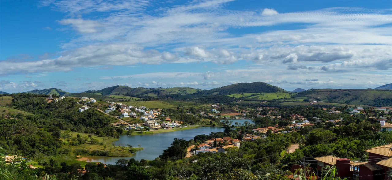
The town calls itself Rainha dos Lagos - the Queen of the Lakes - in reference to the Furnas reservoir, a 1,440-square-kilometer body of water that Brazilians nickname the Sea of Minas. The reservoir flooded the valley when the Furnas hydroelectric dam was built, drowning the old town and submerging the colonial-era church of nearby Guape. When the water level drops more than ten meters, the church's ruins emerge again, visible from the lake surface. Capitolio itself sits 766 meters above sea level on the northern edge of the reservoir, east of the regional hub of Passos. The city proper was elevated from district to village status in 1939, and became a municipality in 1948 - a twentieth-century creation, young enough that some of its elders remember the construction of the lake that reshaped the landscape.
The Canyons and the Rockfall
The rock formations of Furnas Lake rise more than twenty meters above the water in sheer cliff walls where the reservoir floods through narrow canyons. Boat tours threaded these passages for years, anchoring in cool inlets where waterfalls dropped from the rim into the green lake below. On January 8, 2022, around 12:30 in the afternoon, a limestone pillar inside one of the most popular inlets - locally called the Lagoa de Furnas canyon - detached from the cliff above and collapsed into the lagoon. Ten people died, all tourists on pleasure boats who could not maneuver away in time. Dozens more were injured. The Brazilian geological survey attributed the failure to a combination of weathering, seasonal heavy rainfall that had saturated cracks in the rock, and the gradual erosion that had carved the canyons in the first place. Tour operators had been warned, but the economic pull of the canyons was strong. After the disaster, the state imposed new restrictions on how close boats could approach the cliffs.
An Artificial Beach and a Small Economy
The reservoir drives nearly all of Capitolio's tourism economy, but it shapes the town in less dramatic ways too. In 1988, the municipality inaugurated the Praia Artificial de Capitolio - an artificial beach along the Rio Piumhi covering almost 25,000 square meters. It has bathrooms, a covered area for festivals, two sports courts, and walking paths. The town's Carnival celebrations move here each year, bringing visitors from Belo Horizonte 270 kilometers away and from Ribeirao Preto 225 kilometers further south. Beyond tourism, the economy is quieter: cattle for dairy, coffee, soybeans, and corn. The region has quarries that extract Pedra Mineira, a locally valued stone. In 2005, municipal GDP reached roughly R$58 million, modest by Minas Gerais standards but rising as tourism grows.
Morro do Chapeu and the High Country
Above the reservoir, the land rises to Morro do Chapeu - the Hat Mountain - at 1,293 meters. The summit holds a plateau of tropical vegetation and springs that fall as waterfalls down the slopes. Wolves, armadillos, and tamanduas (anteaters) still live in the thick cover. From the top, the Sea of Minas spreads to the horizon, and you can see the towns of Capitolio, Guape, Alpinopolis, and Nova Barra arranged around the lake's irregular shoreline. Thirty-one kilometers from the urban area, the Cachoeira Lagoa Azul falls into a series of natural pools, clear enough to see fish in the deeper basins. The landscape rewards hikers who go beyond the cliff-top overlooks that draw the boat-tour crowds - the back country is quieter, and the trails are older.
A Human Development Index
The town's 2000 Human Development Index score of 0.785 placed it 96th out of 853 municipalities in Minas Gerais and 941st of 5,138 nationally. Literacy reached 89 percent. Life expectancy averaged 74 years across both sexes. In 2000, per capita monthly income sat at R$252 - below both the state average of R$276 and the national average of R$297. The numbers describe a town doing reasonably well for rural Minas Gerais but under persistent economic pressure. The January 2022 rockfall was the kind of event that could have devastated a town dependent on outdoor tourism. Capitolio has instead rebuilt its tourism economy around tighter regulation and a more sober respect for the geological forces that carved its canyons. The cliffs remain. So do the visitors. The boats simply do not anchor as close anymore.
From the Air
Located at 20.61 degrees S, 46.05 degrees W in southwestern Minas Gerais state. Elevation 766 meters in town; Morro do Chapeu reaches 1,293 meters nearby. Nearest regional airports are Pouso Alegre or Varginha (SBVG); major connections through Belo Horizonte (SBCF) 270 km east, or Sao Paulo (SBSP). Best viewing altitude 4,000-6,000 feet to appreciate the 1,440-square-kilometer Furnas reservoir - the Sea of Minas - carved into the surrounding hills, with the distinctive canyon formations visible on the reservoir's rocky shores.
Nearby Stories
- Boa Esperança, Minas Gerais 38 km away
- Southeast Brazil 45 km away
- Lavras 52 km away
- Guaxupe 54 km away
- Lagoa da Prata 54 km away
- São Gonçalo do Pará 69 km away
- José Chiachiri Municipal Historical Museum 104 km away