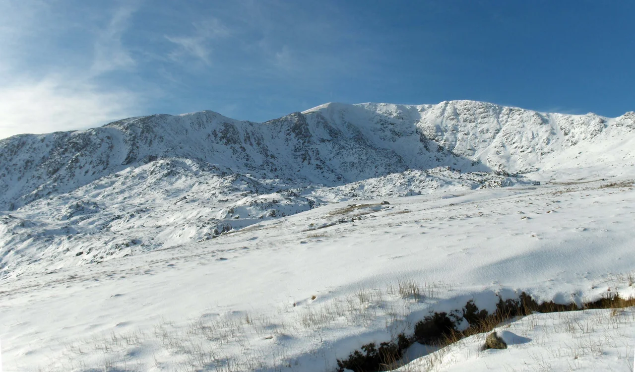

Carnedd Llewelyn
The name on the map is a cairn for a prince Edward I never let bury. Carnedd Llywelyn - "Llywelyn's cairn" - rises 1,064 metres above the Conwy valley, the second-highest summit in Wales by prominence, and the second-highest by altitude only because Snowdon edges it by twenty-one metres. The Welsh form keeps the y; English maps prefer Llewelyn. Either way, the syllables belong to Llywelyn ap Gruffudd, the last sovereign prince of Wales, whose head went to London in 1282 and whose name climbed quietly back into the highest ground of his old kingdom.
The Roof of the Carneddau
Carnedd Llywelyn sits at the centre of the long north-east to south-west spine of the Carneddau range, with Carnedd Dafydd to the south-west and Foel Grach to the north. A subsidiary ridge runs north-west to Yr Elen. The summit itself is a flat, boulder-strewn plateau, not a peak in the dramatic sense - more like the broken crown of an enormous ancient massif worn flat by ice. In winter the plateau holds snow in volumes rare elsewhere in Britain, and old snow patches survive in the southern gullies into July most years, sometimes later. The highest lake in Wales, Llyn Llyffant, sits in the lee of the summit, a pool of meltwater catching the slow drainage of those snowfields. The cliffs below the main ridges - Ysgolion Duon, "the Black Ladders," and Craig yr Ysfa - are among the most respected rock climbing crags in Snowdonia.
A Cairn for the Last Prince
The story most often told is the obvious one: that Carnedd Llywelyn and the neighbouring Carnedd Dafydd are named for Llywelyn ap Gruffudd and his brother Dafydd ap Gruffudd, the last two princes of independent Wales. Both died at Edward's hands within months of each other in 1282-1283. An alternative tradition reaches further back, to Llywelyn the Great and his son Dafydd ap Llywelyn, the dynasty's earlier peak. Welsh writers and the Snowdonia National Park Authority prefer the spelling Llywelyn; the Ordnance Survey, settled into nineteenth-century habit, prints Llewelyn. The first recorded poem about the mountain is older than the dispute - Rhys Goch Eryri composed his "Carnedd Llywelyn" around 1400, when memory of the conquest was still close enough to mourn.
Climbing Out of Cwm Llafar
There are four classic ways up. From Gerlan above Bethesda the path follows the Afon Llafar deep into the cwm before climbing to the summit of Yr Elen and traversing the short connecting ridge. From Helyg on the A5 a track leads to Ffynnon Llugwy reservoir before the long climb up beside Craig yr Ysfa. The third option is the full ridge walk - Pen yr Ole Wen or Foel-fras to the summit - one of the great traverses in Wales. Most years the route is on grass and boulders. In a hard winter the plateau is closer to the Cairngorms than to anything south of Glasgow: knee-deep drifts, whiteout, and the constant risk of stepping off a cornice you cannot see.
The Avro Lincoln on the Plateau
On the night of 14 March 1950, several RAF Avro Lincoln bombers from No. 230 Operational Conversion Unit took off from RAF Scampton on a cross-country exercise. Weather closed in at home. A controller at RAF Barton Hall diverted three of the Lincolns to RAF Valley on Anglesey. At 2:55 a.m. on 15 March, the crew of RF511 lost contact. Five minutes later the other two aircraft landed safely. RF511 was found at 5:20 a.m. on Carnedd Llywelyn, wrecked across the plateau with all six crew dead. The Court of Inquiry concluded the pilot had misheard a radio instruction - "turn 180 degrees" became "turn 80 degrees," and a controlled flight into the highest ground in Gwynedd followed. The wreckage is still there. In 2002 a memorial plaque was placed at the crash site. Walkers crossing the summit in clear weather sometimes pause at a scatter of corroded aluminium and wonder what it is.
Why People Keep Coming
The Aetherius Society, a UFO religion founded by George King in the 1950s, lists Carnedd Llywelyn as one of nineteen holy mountains worldwide. The classification is unusual but the impulse is not. The summit plateau looks out over almost the whole of Snowdonia: Tryfan's spine to the south-west, the Glyderau's chaos beyond it, the Conwy's silver thread running north-east toward Llandudno, and on a clear day the Isle of Man rising from the Irish Sea. The high ground is mostly silent. The wind on the plateau in May still has winter in it. Llywelyn's cairn has been here for seven hundred years; the snow patches in the southern gullies are older than him by ten thousand.
From the Air
Located at 53.16°N, 3.97°W. The summit rises to 1,064 m (3,491 ft); maintain minimum 2,500 ft above summit (FL060 or higher) for safe terrain clearance. Visible 30+ nm from any direction in clear weather, with the long Carneddau spine running north-east from Carnedd Dafydd to Foel-fras. Nearest airports: EGCK (Caernarfon Airport) 11 nm WSW, EGOV (RAF Valley) 22 nm WNW. Watch for severe rotor and orographic turbulence in northerly or westerly winds, plus persistent cap cloud below freezing level. Long-lying snowfields visible on south-facing gullies well into summer.
Nearby Stories
- Tudweiliog 3.6 km away
- Denbigh Castle and Town Walls 6.4 km away
- Rhoscolyn Lifeboat Station 7.6 km away
- Butlin's Pwllheli 20 km away
- East–West Interconnector 20 km away
- New Brighton Lifeboat Station 31 km away
- Battle of Oswestry 31 km away
- Celtic Array 44 km away