
Castledawson
Mossbawn, the farm where Seamus Heaney spent his first fourteen years, sits in the townland of Tamniaran, about a mile northwest of Castledawson on the road to Toome. The future Nobel laureate was born here on 13 April 1939, the eldest of nine children. He would later write that the well at Mossbawn - cold, dark, ringed with mossy stone - was where he first learned what poetry felt like: "You felt for that long time, alone in the cool darkness, that you really were in touch with the source of everything." The village down the road was where Heaney went to school, where his family worshipped, where his father bought and sold cattle at the market. Castledawson has the modest air of any small Londonderry village. It is also where one of the twentieth century's finest poets first looked into a well and saw a world.
Dawson's Bridge
Joshua Dawson founded the village in 1710 and it was originally called Dawson's Bridge - after the stone bridge he built across the River Moyola, then the largest single-span stone bridge in Ireland. Three years later, in 1713, he built the manor house that gave the village its modern name. Locals call it a castle. Architecturally it is a large country house, but it stood at the head of the Shanemullagh estate, and the name stuck. Joshua Dawson was Chief Secretary for Ireland - the senior administrative officer of the Irish executive - which explains how a Londonderry village came to be named after a single landowner. The Dawson family also founded Christ Church, on the edge of the estate, in the early eighteenth century. The bridge over the Moyola is still there, much rebuilt; the church still stands. The descendants of Joshua Dawson include James Chichester-Clark, who served as Prime Minister of Northern Ireland from 1969 to 1971.
The Castledawson Incident
On 29 June 1912, the village name was briefly in newspapers across Britain and Ireland for the worst reasons. A large group of Ancient Order of Hibernians members, allegedly drunk after a parade, clashed in Castledawson with a party of Presbyterian Sunday School children who were returning from their annual excursion. The Reverend James Armour, a prominent Presbyterian minister, blamed alcohol and "the mad Orangemen of the locality," whom he suspected of provocation. But the response in Belfast was disproportionate and catastrophic. In the rioting that followed, around 2,000 Catholic shipyard workers and 500 Protestant Home Rulers were violently driven from their jobs at the Workman and Clarke shipyard. A clash between drunken parade-goers and Sunday-school children in one Londonderry village had set off communal violence in Ireland's largest shipyard.
The Soldier on the Bridge
In March 1922, during the closing months of the Irish War of Independence, the Irish Republican Army shot dead an off-duty Special Constable in Castledawson while carrying out a bomb attack on the Moyola Bridge. The dead man was a member of the Ulster Special Constabulary, the auxiliary force raised to defend Northern Ireland during partition. The attack was one of dozens during this period in which sectarian violence and political violence became almost indistinguishable along the new border. The bridge survived. Six months later, Northern Ireland formally opted out of the Irish Free State and the new border became permanent.
Heaney Country
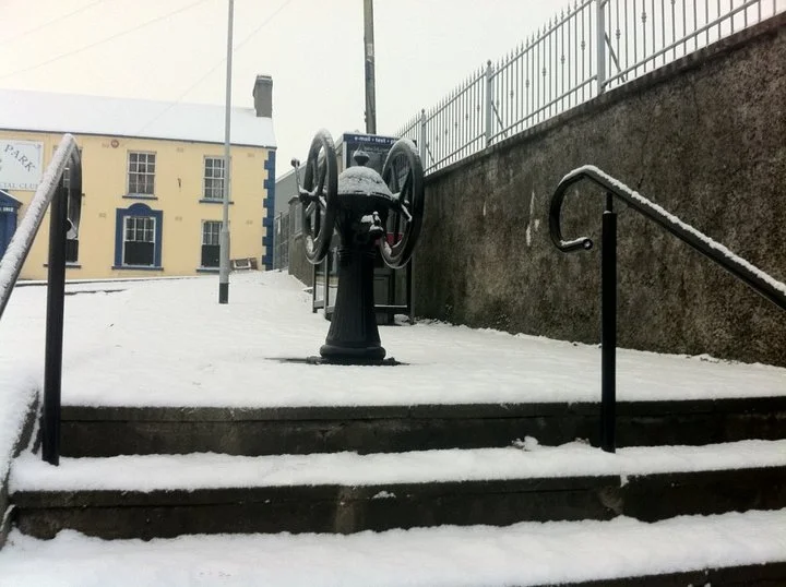
Seamus Heaney spent his earliest years on his father's farm at Mossbawn, between Castledawson and Toomebridge, the eldest of nine children in a Catholic family on a rural Ulster landscape that he would later make universally recognisable. The poems of his first collection, Death of a Naturalist (1966), are full of this specific country: the well, the pump at "the gravel" in Castledawson's Main Street, the bog water of the Moyola, his father digging potatoes "twenty years away." When Heaney won the Nobel Prize in Literature in 1995, the world's attention turned for a moment to a stretch of County Londonderry that had been, for most outsiders, anonymous. "Between my finger and my thumb," Heaney wrote in "Digging," "the squat pen rests. / I'll dig with it." The pen, in some sense, was dug from the soil between Castledawson and Bellaghy.
Sweet Milk and Aerospace
In 1943, Nestlé built a factory in Castledawson that produced sweetened condensed milk. The factory closed in the 1970s, but the building did not stand empty for long. Today the site houses Ditty's Bakery, multiple times a winner of UK speciality food awards, and Moyola Precision Engineering, which produces aerospace components for international clients. The economic shift - from a Swiss multinational making canned condensed milk for the wartime market to a precision aerospace firm exporting to Airbus and Boeing - mirrors broader changes across Ulster's small towns since partition. The River Moyola itself still runs salmon, perch, eel, trout, bream and pike. Dominating the horizon southwest of the village is a dramatic ráth - an ancient ringfort, the kind of earthwork that predates Joshua Dawson by perhaps a thousand years.
The Long Wait for a Bypass
From 1971, the main A6 Belfast-to-Derry road passed through Castledawson, after the nearby Castledawson roundabout was built in anticipation of the M22 motorway extension that was never completed. The village waited for a bypass. In 1992, a single-carriageway A6 upgrade finally diverted through traffic around Castledawson. As of the mid-2020s, the section is being dualled - bringing what one report called "the end of a 47-year wait for the high-quality bypass it was promised, all those decades ago." That long wait says something about the place. Castledawson is a small village - 2,289 people at the 2011 census, mixed roughly 53% Catholic and 43% Protestant. It sits between bigger places: Magherafelt to the north, Toome to the east, Lough Neagh four miles southeast. People here have learned to wait. They have also produced, between Joshua Dawson's bridge and Heaney's pen, a remarkable amount of what gives this corner of Ulster its name.
From the Air
Located at 54.78°N, 6.56°W in County Londonderry, Northern Ireland, on the River Moyola about four miles from the northwest shore of Lough Neagh. Recommended viewing altitude 1,500-3,000 ft AGL to take in the Moyola valley, the ráth ringfort southwest of the village, and the village's setting between Lough Neagh to the southeast and the Sperrins rising in the west. Nearest international airport: Belfast International (EGAA), about 25 nm southeast. City of Derry (EGAE) is about 35 nm northwest. The A6 Belfast-Derry route runs just south of the village; from cruising altitude the dualling works are easily picked out.
Nearby Stories
- Agivey River 5.3 km away
- Portadown 8.4 km away
- City of Derry Airport 8.7 km away
- 1990 British Army Gazelle shootdown 8.9 km away
- Carrickfergus 12 km away
- Gortin 14 km away
- Downpatrick and County Down Railway 25 km away
- Mull of Kintyre 34 km away