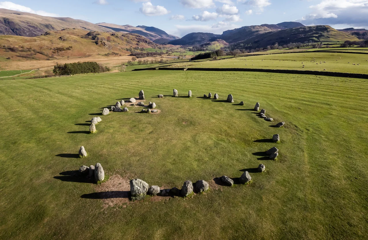

Castlerigg Stone Circle
Try to count the stones at Castlerigg. There is a tradition - shared with most other British stone circles - that no two counts ever agree. At Castlerigg this is partly because soil erosion has revealed packing stones that were originally buried, so the answer depends on whether you count them. Most people say forty. Some say thirty-eight. The National Trust sign at the gate commits to forty. Whatever you settle on, the stones have been standing on this raised plateau east of Keswick for around five thousand years - one of the earliest stone circles in Britain, possibly in Europe - and the people who put them there left no explanation.
What a Glacier Left
The stones are not quarried. They are glacial erratics, boulders of andesitic lava and volcanic tuff dropped here when the last ice sheets retreated about ten thousand years ago. They belong to the Borrowdale Volcanic Group, the same rock that built Helvellyn and Scafell. Castlerigg's builders did not need to drag stone from far away. The raw material was already on the ground, scattered across the glacial till the ice had left behind. They chose a flattened circle, 32.6 metres wide at its broadest and 29.5 at its narrowest. The heaviest stone weighs roughly sixteen tonnes. The tallest reaches 2.3 metres. There is a wide gap on the north side that may have been an entrance. And on the eastern side, abutting the inner edge of the ring, the builders set a rectangular arrangement of ten more stones - a feature found in no other British stone circle - whose purpose remains a complete mystery.
The Mountain Amphitheatre
Castlerigg sits on a low plateau that forms the centre of a natural amphitheatre of fells. From inside the ring, the eye travels around a 360-degree horizon of mountains: Helvellyn to the south-east, Skiddaw and Blencathra to the north, Grasmoor to the west. The archaeologist John Waterhouse called it "one of the most visually impressive prehistoric monuments in Britain," and it is hard to disagree. Astronomers have noted that the sunrise during the September equinox appears precisely over the summit of Threlkeld Knott, a hill 3.5 kilometres east of the circle. Whether the builders chose this site for that alignment, or simply for the encircling mountains and their open ground, we cannot know. Current archaeological thinking links Castlerigg to the Neolithic Langdale axe industry, whose factories in the nearby Langdale fells produced polished stone axes traded across Britain. The circle may have been a meeting place where those axes changed hands - and where the transfers were ritualised, sanctified, made meaningful in ways the surviving stones cannot tell us.
Druids and Antiquarians
The first published description of Castlerigg appeared in 1776, eleven years after its author had died. William Stukeley, an early antiquarian, had visited the site in 1725 and described "another Celtic work, very intire," sitting on "an eminence in the middle of a great concavity of those rude hills." The locals called the stones the Carles - or, as Stukeley noted, "corruptly I suppose, Castle-rig." Stukeley, like his predecessor John Aubrey, made the now-discredited assumption that megalithic monuments were the work of Iron Age Druids. The connection stuck. For two centuries afterwards, prints and tourist guides labelled Castlerigg a "Druidical Circle." The Romantics loved it. Samuel Taylor Coleridge visited in 1799 with William Wordsworth and wrote of mountains "in orderly array as if evoked by and attentive to the assembly of white-vested wizards." John Keats came too, although he seems to have been unimpressed, dismissing the stones in his poem Hyperion as a "dismal cirque / Of Druid stones, upon a forlorn moor."
The Single Excavation
Only one archaeological excavation has ever been carried out at Castlerigg, in October 1882, by a man named W. Kinsey Dover. He dug a narrow trench through the inner rectangular enclosure and found, near the bottom, "a few small pieces of burned wood or charcoal" and "some dark unctuous sort of earth." He took samples. The samples have since been lost. No carbon dating has ever been done on the circle itself. The proposed date of around 3200 BC is based on comparison with other stone circles and on the dating of the Langdale axe factory at Pike o' Stickle, which seems to have wound down by 3300 BC. Modern excavation would almost certainly answer some of the standing questions, but English Heritage will not permit it. The site is too important. The stones, having waited five thousand years to be understood, will have to wait a little longer.
A Field Bought by Public Subscription
In 1883, the year after Dover's dig, Castlerigg became one of the first sites scheduled under the new Ancient Monuments Protection Act. In 1913, Canon Hardwicke Rawnsley - one of the three founders of the National Trust - organised a public subscription to buy the field the circle stands in. He then donated the field to the National Trust, where it remains. English Heritage looks after the stones themselves. The arrangement, like the stones, is older than most people realise: this little patch of grass east of Keswick is one of the foundation acquisitions of the British conservation movement. Today thousands of visitors arrive every year, making Castlerigg the most-visited stone circle in Cumbria. Most of them, sooner or later, give in and try to count the stones.
From the Air
Castlerigg Stone Circle sits at 54.60 degrees north, 3.10 degrees west, on a raised plateau about 1.5 miles east of Keswick. From the air the circle reads as a faint pale ring on green pasture, framed by the dark mass of Skiddaw to the north and the higher Helvellyn range to the south-east. The A66 road runs just north of the site. The nearest licensed airfield is Carlisle Lake District (EGNC), roughly 23 nm north; Newcastle (EGNT) is approximately 60 nm east. Cruise altitudes of 3,000-5,000 feet give views of the surrounding mountain amphitheatre. Mountain weather changes quickly - cloud often forms over the surrounding fells while the Castlerigg plateau itself remains clear.
Nearby Stories
- Parton railway station 4.4 km away
- Brough Castle 11 km away
- Cartmel Racecourse 13 km away
- Caerlaverock Castle 15 km away
- Vindolanda 18 km away
- Yorkshire Dales 25 km away
- Cashtal yn Ard 55 km away