.jpg)
Parton railway station
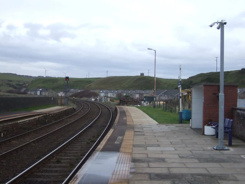
Take the Cumbrian Coast Line south from Whitehaven and within minutes the train is rolling along, almost literally, the seashore. The cliffs rise on the left; the Irish Sea breaks on the right. Then, before you have quite registered where the right-of-way actually is, the train brakes hard and grinds along at fifteen miles an hour because the alternative is that the rails fall into the water. Parton railway station is just here - a pair of brick shelters, no buildings, no ticket machine, no staff, no step-free access to either platform. It is one of the most extraordinary small stations in Britain, not for what is there, but for what is barely keeping it there.
A Line on the Edge
The Cumbrian Coast Line between Parton and Harrington runs at the very foot of the cliffs. Sea erosion threatens it constantly. Landslides from above threaten it constantly. Network Rail keeps watch on both. The route is restricted to a single track over much of this section, and the fifteen-mile-an-hour speed limits exist for a single overriding reason: a faster train, in the wrong place at the wrong time, would derail. The BBC ran a feature in 2015 titled simply 'The railway lines alarmingly close to the sea.' This was one of them. There was once a signal box immediately north of the station, controlling all of this. The box was in such poor condition that it was closed and demolished in May 2010; control passed to the adjacent box at Whitehaven Bransty.
Two Brick Shelters
There are no permanent buildings here other than brick shelters on each platform - just enough to keep a passenger out of the worst of a winter squall. The station is not staffed. If you want to travel, you buy your ticket on the train or in advance, because there is no ticket machine. Train running information comes by telephone, digital CIS screens, and timetable posters glued to the wall. There is no lift, no ramp, and no step-free access to either platform. The Department for Transport classifies it as a Category F2 station - the smallest, lowest-traffic tier. This is, in short, a halt rather than a station. It exists because Parton village exists, and Parton village exists because people have lived in this strip between the cliff and the sea for a long time.
Opened in 1847, Saved in 2018
Parton station opened in 1847, originally on a London and North Western Railway route. It has served the village ever since, with some long, lean stretches in between. For many years the service south of Whitehaven was just four trains a day each way - a skeleton timetable that left commuters and visitors largely dependent on cars and buses. Then in May 2018, the operator Northern restored a regular through service south from Whitehaven to Barrow-in-Furness via the coast, the first such service in more than forty years. Now there is roughly an hourly service through Parton from mid-morning until early evening, with later trains terminating at Whitehaven. A few through trains run all the way to Lancaster via the Furness Line.
The Sea, the Coal, the Cliffs
Parton sits between Whitehaven and Workington on a coast that has been industrial as long as it has been inhabited. Coal mines from the cliff edge - including Haig Colliery, three miles south - sent ore and product up and down this line for over a century. The Cumbrian Coast Line carried miners to work and coal to port. Today the trains carry tourists doing the Cumbria Coast as a scenic ride, walkers heading for St Bees and the Wainwright Coast-to-Coast, and the small but steady commuter traffic between Whitehaven and Carlisle. The hourly trains north go to Carlisle; the southbound trains mostly run all the way through to Barrow-in-Furness, though no late evening service operates south of Whitehaven.
What You See From the Platform
Stand on the Parton platform between trains and the view is mostly weather. The Irish Sea fills the western horizon; the cliffs rise immediately behind you. On a clear day the Isle of Man is visible, smudged across the water about thirty-five miles out. On a wet day there is just grey going to white going to grey. The line crews who keep this stretch of railway running are doing work that most rail passengers never think about: monitoring slope stability, mapping every crack in the cliff face, reinforcing the rail bed against the next storm surge. The station itself is small enough that you could overlook it. But like St Bees Lifeboat Station a few miles south, it is the kind of small civic infrastructure that quietly stitches a coastline into the rest of the country - and keeps doing so, even when the sea is patiently trying to take it back.
From the Air
Parton railway station sits at 54.570°N, 3.582°W, on the Cumbrian coast about a mile north of Whitehaven. Best viewed at 1,500-3,000 feet, where the railway line is recognisable as a thin ribbon at the very base of the cliffs, with the village of Parton tucked behind. Carlisle Lake District (EGNC) lies 28nm north-northeast; the Isle of Man (EGNS Ronaldsway) sits 35nm west. Whitehaven harbour 1nm south is an obvious landmark, as is the sweep of the Solway Firth to the north and St Bees Head 4nm to the south.
Nearby Stories
- Derwentwater 1 km away
- Cashtal yn Ard 10 km away
- Buittle Castle 14 km away
- Carlisle Castle 15 km away
- Isle of Whithorn 16 km away
- Conishead Priory 17 km away
- Black Combe 24 km away
- Battle of Glen Trool 32 km away