Ceilândia
The name started as three letters on a government document: CEI, short for Campanha de Erradicacao das Invasoes - the Campaign for the Eradication of Invasions. By 1969, only nine years into Brasília's existence, nearly 80,000 people were living in what the state called irregular settlements around the planned capital, squatting in the shadows of Oscar Niemeyer's pristine modernist plan. The solution was Ceilândia, a grid of 17,619 lots staked out on the dusty cerrado in 1970 to hold the workers who had built the capital but were not welcome to live in it. Today, Ceilândia is the largest city in the Federal District. More people live here than in Brasília proper.
Nine Months to Build a City
The transfer happened fast. In nine months, families were moved out of the encampments ringing the Plano Piloto and into the new grid west of Taguatinga. There was no water. No electricity. No public transport. Residents fought dust in the dry season and flash floods in the wet, laying out streets and lots on ground that until recently had been savanna. The official founding date is March 27, 1971, a Saturday that marked less a celebration than a relocation completed. The governor who ordered the campaign, Helio Prates da Silveira, wanted the capital's periphery cleared. The people the policy displaced became Ceilândia's first residents - construction workers, domestic laborers, families who had come to Brasília for work and been told, in effect, that they had built something they could not inhabit.
The Northeast, Relocated
About 70 percent of Ceilândia's roughly 398,000 residents trace their roots to Brazil's Northeast - the drought-prone states of Pernambuco, Paraiba, Ceara, Bahia. They or their parents rode the pau-de-arara trucks south looking for work on the capital's construction sites in the late 1950s and 1960s. When Brasília's monumental axis was finished, the work ended but the workers stayed. Their culture stayed with them. Thirteen open-air markets - feiras livres - operate across the city, selling cassava and coriander, leather sandals and forro records. The Feira Permanente, at seven thousand square meters, is the largest, and the Feira do Produtor supplies nearly half the Federal District's wholesale produce. In 2020, Ceilândia was officially named the Capital of Northeastern Culture of the Federal District, formalizing what the food stalls and accordion players had announced for fifty years.
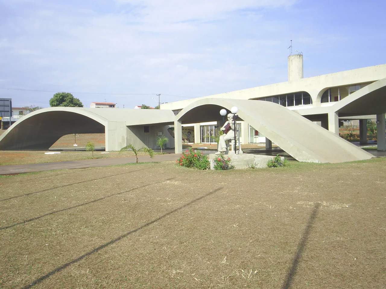
Niemeyer on the Periphery
One building in Ceilândia was designed by the same architect who drew the capital itself. The Casa do Cantador - the House of the Singer - opened in 1986 as a cultural center dedicated to the poets and musicians of the Northeast, particularly the repentistas who improvise verse in rhymed contests. Oscar Niemeyer, who had spent his life designing ministries and palaces for Brasília's government core, donated the design. The building's curving concrete forms are his signature, but the program is different: this is where singers come to duel, where forro bands play, where Northeast Brazil's oral traditions get a stage in the Federal District. The other symbol of the city is simpler - the Caixa d'Agua, the water tower at the center of the largest market, a landmark that doubles as a reminder of what the original residents did not have.
The Largest Electoral College
The satellite that was never supposed to rival the capital now dwarfs it at the ballot box. Ceilândia has the largest electoral college in the Federal District - more voters than Brasília itself. The layout mimics the Plano Piloto in miniature: 91 residential superblocks arranged in a grid, intercalated with commercial, religious, and educational zones, a diagram of urbanism drawn at the scale of the displaced. There are 4,500 commercial establishments, 1,600 small industries, more than 160,000 economically active residents. Three metro stations - Ceilandia Sul, Centro, and Norte - connect the city to Brasília along the rail line, with two more planned. The three highways serving the city run east toward the capital: DF-075, DF-085 (the Linha Verde), and DF-095 (the Via Estrutural), arteries that the city uses to commute toward the place that once wanted it invisible.
The City That Outgrew Its Origin
Fifty years on, the asymmetry has inverted. The administrative region created to contain the capital's problem population has more people than the capital it was designed to protect. Ceilandia Esporte Clube plays at Estadio Maria de Lourdes Abadia. Three campuses of higher education operate within the city. The same government that once counted the settlers as an invasion now counts them as its largest voting bloc. The apartheid of Brasília, as one headline called the original policy, produced its own center of gravity - a Northeastern capital inside the federal capital, with its own markets, its own music, its own mayor, its own electoral weight. The dust and the flash floods eventually gave way to asphalt and metro lines, but the story of Ceilândia is not that it overcame its origins. It absorbed them, lived them, and turned them into culture.
From the Air
Located at 15.82 degrees south, 48.11 degrees west, about 26 km west of central Brasília. From the air, look for the characteristic Niemeyer-inspired grid of superblocks west of the Plano Piloto, sliced by the DF-095 Via Estrutural. The Caixa d'Agua stands out as a central landmark. Nearby airports: Brasília International (SBBR) to the east. Typical cruising view from 8,000-12,000 feet; clear visibility common in the dry season (May to September).
Nearby Stories
- Valparaíso de Goiás 7.8 km away
- Formosa, Goias 26 km away
- Pireneus State Park 36 km away
- Planaltina, Goiás 40 km away
- Anápolis 59 km away
- Unaí 73 km away
- Ceres, Goiás 117 km away
- Mambaí 181 km away