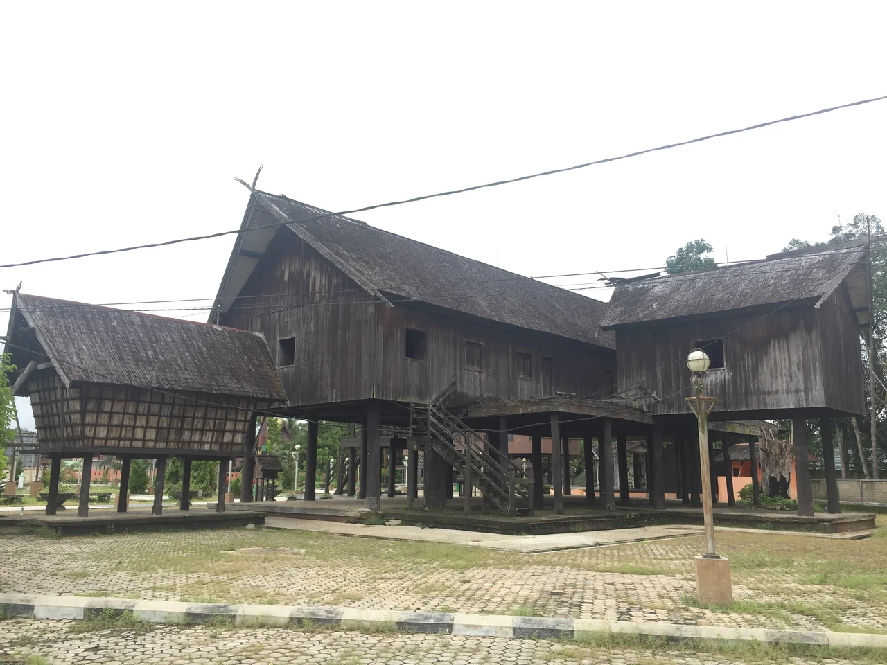
Borneo's Dayak Heartland
The longhouse stretches 150 meters along the riverbank, built on ironwood stilts that have resisted termites and humidity for generations. Inside, 150 people share a single roof. This is a Huma Betang, the traditional dwelling of the Dayak people, and in Central Kalimantan it is not a museum piece -- it is still how some families live. Indonesia's largest province by area sprawls across 153,800 square kilometers of Borneo's interior, a territory 1.5 times the size of Java, threaded with rivers that function as highways through rainforest so dense that roads have never fully replaced them.
A Province Born of Defiance
For centuries, the central region of Kalimantan and its Dayak inhabitants were ruled by the Muslim Sultanate of Banjar. After Indonesian independence following World War II, Dayak tribes demanded what they had long been denied: political autonomy. On 23 May 1957, the Indonesian government split South Kalimantan in two, creating Central Kalimantan as the nation's seventeenth province. President Sukarno appointed the Dayak-born national hero Tjilik Riwut as its first governor and designated a new capital in the jungle: Palangka Raya, a name combining the Dayak Ngaju word for sacred site with the Malay word for vast. Riwut personally led the construction of the city, which was officially made the provincial capital on 1 January 1960.
Rivers as Roads
Eleven major rivers drain from the Schwaner Mountains in the north to the Java Sea in the south, and they remain Central Kalimantan's circulatory system. The Barito stretches 900 kilometers, the Kapuas and Kahayan each run roughly 600 kilometers, and even the shortest of the major waterways, the Jelai, covers 100 kilometers. With infrastructure still underdeveloped across much of the province, these rivers carry people, goods, and culture between settlements. Towns cluster along their banks. The provincial economy depends on them. Eighty percent of the terrain is covered in dense forest, peatland swamps, and mangroves, terrain that has resisted the road-builders who transformed other Indonesian provinces.
The Dayak Mosaic
Central Kalimantan is the most Dayak of Borneo's provinces, and the Dayak themselves are not one people but many. The three major tribal groups -- Ngaju, Ot Danum, and Ma'anyan -- branch into sub-groups including the Lawangan, Taboyan, Dusun Siang, and Kadori, each with distinct traditions. The Ot Danum remain in the upstream regions, preserving a traditional way of life in longhouses, subsisting through hunting, fishing, and basic agriculture. Village elders practice traditional medicine and mark their status with intricate body tattoos and heavy ear adornments. The Ngaju have moved downstream, assimilating to varying degrees with the diverse populations of the lower river towns -- Javanese, Madurese, Batak, Bugis, Chinese, and more than a dozen other ethnic groups that make up Indonesia's mosaic.
Swords, Shields, and Sacred Drums
Dayak material culture is built to last, quite literally. The Mandau, a single-edged sword with a blade of Mantikei iron 70 centimeters long, features a hilt carved from wood, deer horn, or occasionally human bone. Its companion is the Talawang, a shield carved from Bornean ironwood and painted in bright ceremonial colors -- once carried into battle, now displayed in Kaharingan temples and public buildings. Musical traditions run equally deep. The Japen, a lute-like instrument strung with nylon, accompanies Karungut recitation, a form of Dayak oral literature set to musicalized rhyme. The Garantung, a hanging gong similar to the kempul in Javanese gamelan, plays in ensemble with the Gandang Manca, a two-headed drum bound in rattan. These are not relics. They sound during every traditional procession and ritual.
Peat, Fire, and What Remains
Twenty-six percent of Central Kalimantan is peatland, and that statistic carries weight far beyond the province's borders. Peat stores vast quantities of carbon. When it dries and burns -- as it does increasingly during dry seasons amplified by El Nino and the Indian Ocean Dipole -- the smoke crosses international borders and the carbon enters the global atmosphere. The disastrous Mega Rice Project of the 1990s accelerated the damage, draining swamps that had sustained orangutans, proboscis monkeys, and hornbills. Three national parks now protect portions of what remains: Sabangau, Tanjung Puting, and Bukit Baka Bukit Raya. The province also maintains 67 traditional law areas called Kedamangan, each led by a Damang -- a system that recognizes Dayak customary governance alongside the formal state. In Central Kalimantan, the old ways and the new ones coexist, sometimes uneasily, along the same rivers.
From the Air
Centered at approximately 1.50S, 113.50E. The province stretches across most of central Borneo. The main airport is Tjilik Riwut Airport (WAGG) at Palangka Raya. Other airports include Iskandar Airport (WAOI) at Pangkalan Bun and H. Asan Airport (WAOS) at Sampit. Rivers are the most prominent visual features from altitude -- the Barito, Kahayan, and Katingan are clearly visible as brown ribbons winding through green forest. The Schwaner Mountains along the northern border provide terrain variation. During dry season (August-October), haze from peat fires may obscure the landscape.
Nearby Stories
- The Night Kasongan Market Burned 19 km away
- The Million-Hectare Mistake 30 km away
- The River of Four Names 94 km away
- Sixty Seconds Over Banjarmasin 105 km away
- Oil, Empire, and the Fight for Borneo 215 km away
- Kyai Gede Mosque 235 km away
- The Bay That Burned 255 km away
- The Monsun Boat That Almost Outlasted the War 303 km away