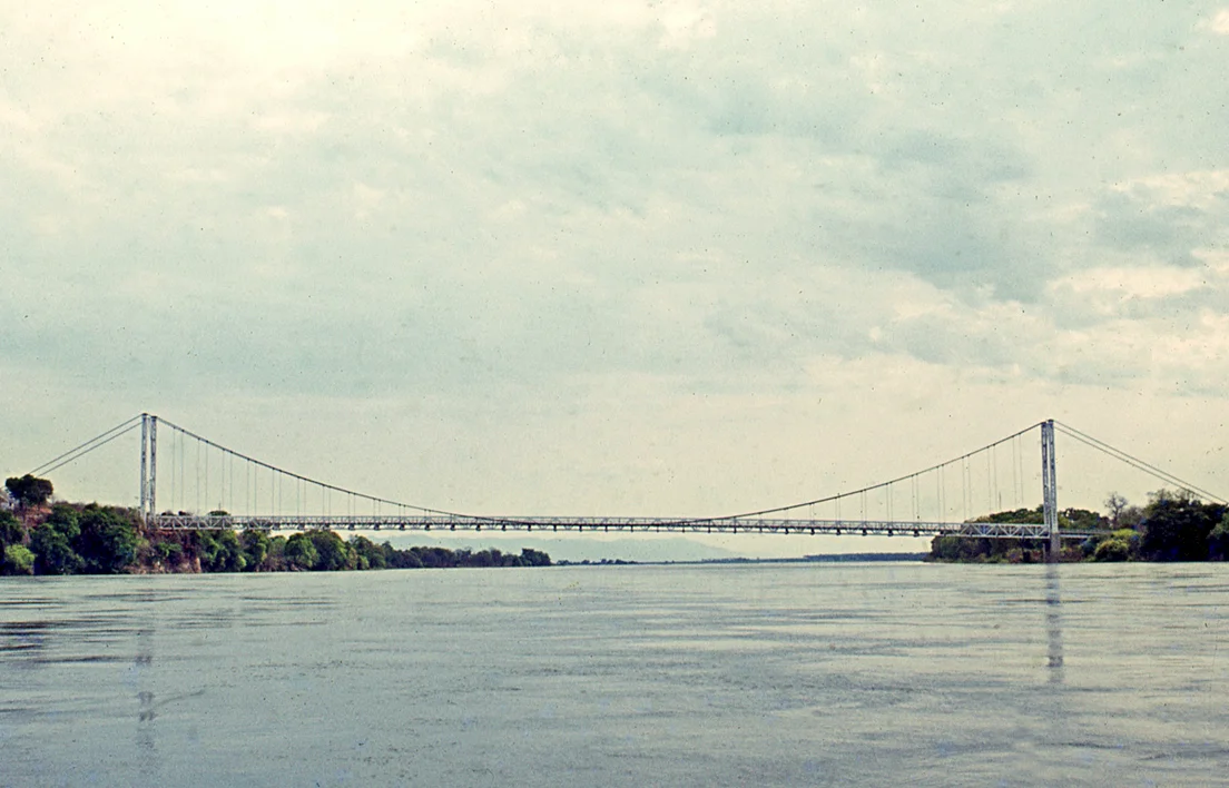
Chirundu Bridge
When the Otto Beit Bridge opened in May 1939, it was the first modern suspension bridge outside the United States to be built with parallel wire cables. That engineering distinction mattered because the Zambezi it crossed could not be bridged with an ordinary pier-and-span design. Before the Kariba Dam went up two decades later, the river flooded annually with a violence that required a single 320-meter clear span - no piers in the water, nowhere for the torrent to catch. Today two bridges cross here, a rare double crossing on a river that for most of its 2,574 kilometers has almost none.
A Beit Trust Bridge
The Otto Beit Bridge was named for the younger of the Beit brothers - German-born Jewish financiers who became fabulously wealthy in South African diamonds and gold, and whose estates funded a run of colonial-era infrastructure across central and southern Africa. The Beit Trust bankrolled the Beit Bridge across the Limpopo, the Kafue Bridge downstream of its namesake river, the Luangwa Bridge on the road east, and Chirundu. These bridges connected the mining interior to the coast - the logic of empire made steel. Dorman Long, the British firm that had recently completed the Sydney Harbour Bridge, built the Otto Beit. It cost £186,000, a substantial sum in 1939, and was opened by Lady Lillian Beit, Otto's widow, on 24 May 1939. The design married engineering precision to colonial symbolism - and it worked well enough that it is still carrying traffic nearly ninety years later.
Single Lane, Alternating Traffic
The Otto Beit has always been a single-lane bridge. Trucks and cars take turns across the 382-meter span, which on a busy day means waiting in a queue that sometimes stretches for hours on both sides. The maintenance requirements of a suspension bridge in tropical Africa are constant. Cables corrode. Paint peels. Steel fatigues. As traffic between Zambia and Zimbabwe grew through the 1980s and 1990s, and as trucks got heavier, the old bridge began to approach its limits. The Zambia-Zimbabwe trade corridor carries enormous volumes of copper from the Copperbelt, tobacco from Zimbabwe, and general freight moving north-south through the continent. A single-lane chokepoint was no longer acceptable, and the two governments began planning a replacement.
The Second Bridge (2002)
The new Chirundu Bridge opened on 12 December 2002, 90 meters upstream from its predecessor. Built by Japan's Kajima Corporation with engineering consultancy from Nippon-Koei and Chodai, it is a very different structure - a two-lane, three-span continuous prestressed concrete box girder bridge, 400 meters long and 10.3 meters wide. The design could use piers in the river because Kariba Dam, completed in 1959, had tamed the Zambezi's annual flood. What once required a single clear span could now rest on supports in the water. The new bridge uses the same approaches and border control area as the old one, and was paired with upgrades to both countries' border facilities - part of a long-running effort to turn Chirundu into a One-Stop Border Post where customs and immigration happen in one place instead of twice.
The Only Double Crossing
Chirundu is the only town on the Zambezi where two bridges cross the river. The two spans sit close enough that from the air they look like a parenthesis opening and closing - concrete on the upstream side, steel cables on the downstream. The river here is about 400 meters wide and 65 kilometers downstream of the Kariba Dam wall. The sluices at Kariba, opened in high-water years, send visible pulses through this stretch, though nothing like the pre-dam floods that shaped the original design. Both bridges were once imagined as links in Cecil Rhodes's Cape to Cairo Road dream - a continuous route from South Africa to Egypt that never quite cohered. They remain on what is now the Harare-Lusaka section of the surviving highway network, carrying the trade that actually uses the route regardless of the romance attached to it.
Two Towns, One Border
The Zambian Chirundu is a small dusty town with truck stops and customs agents. The Zimbabwean Chirundu, across the river, is barely a village. The two places share a name and a reason to exist - the border. The climate in the Zambezi valley is hot. The lowest stretches of the river run through one of the warmer corners of southern Africa, and Chirundu's summers can punish anyone who forgot to bring water. For drivers moving between the two countries, the bridges are just a crossing to be cleared. For the engineers who built them, they were landmark projects - Dorman Long's parallel-wire innovation in 1939, Kajima's prestressed concrete solution in 2002. Sixty-three years apart, two very different answers to the same question: how do you get traffic across the Zambezi at this particular spot?
From the Air
Located at 16.04°S, 28.85°E, crossing the Zambezi River at the Zambia-Zimbabwe border. The nearest airports are Harare International (HRE, about 90 nautical miles southeast) and Kariba Airport (KAB, about 35 nautical miles to the west). From cruise altitude the twin bridges are easily visible - two parallel spans crossing a wide, slow river in a deep valley at roughly 400 meters elevation. Kariba Dam and its enormous reservoir are about 65 kilometers upstream to the west, a major navigation landmark. The valley here is the Middle Zambezi - hot, low, with visible escarpments rising to north and south. Best flying conditions in the dry season; haze common in October before the rains.
Nearby Stories
- Kariba Dam 32 km away
- Mana Pools National Park 36 km away
- Rhodesia (region) 37 km away
- Karoi 55 km away
- State House, Lusaka 75 km away
- Luangwa River 96 km away
- Lusaka–Livingstone Road 126 km away
- Luangwa Bridge 143 km away