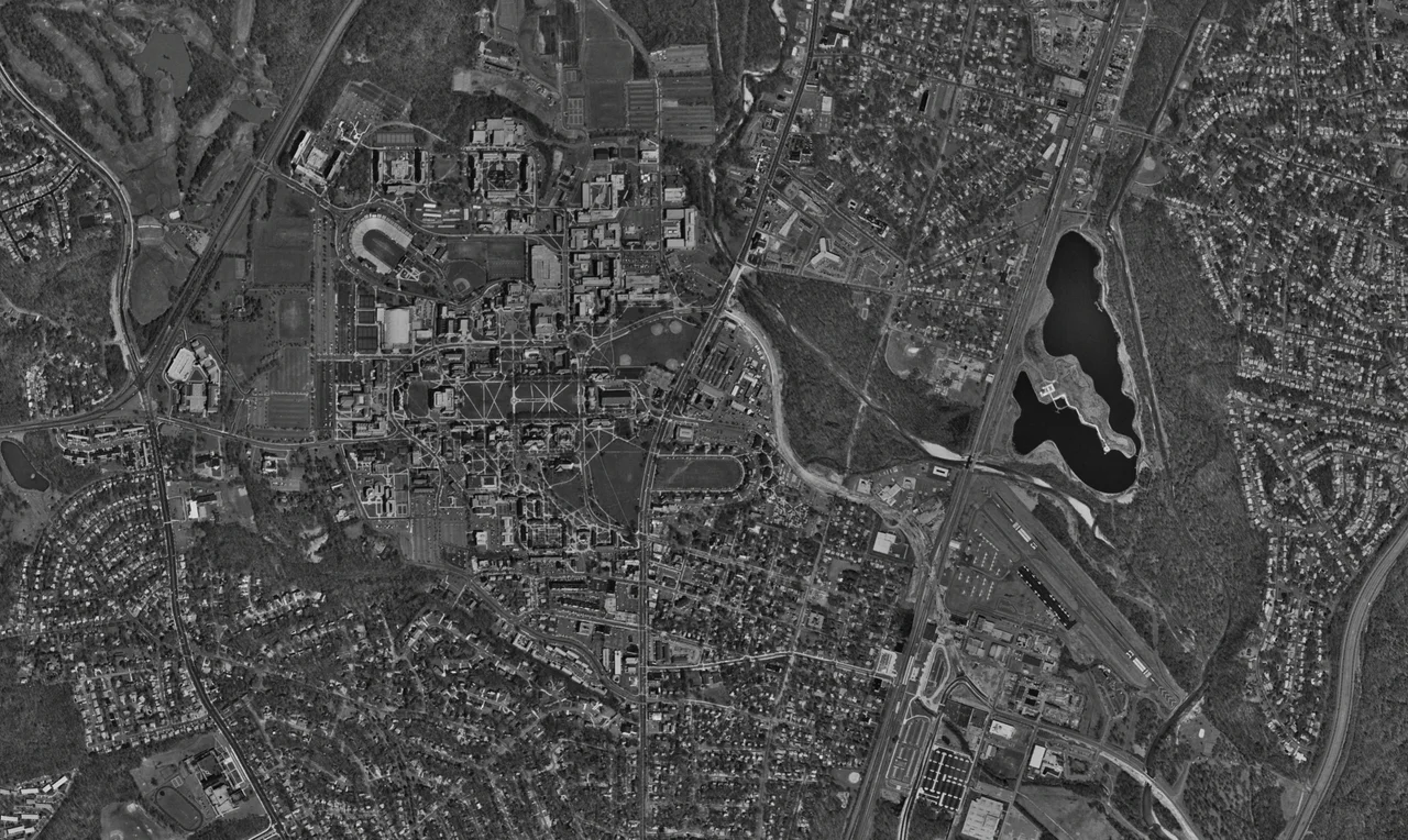

College Park, Maryland
In October 1909, Wilbur Wright stood at the edge of a freshly mowed field in Prince George's County, Maryland, and taught U.S. Army Signal Corps officers to fly. The aircraft was a Wright Model A, the U.S. government's first airplane. The field is still there. It has new hangars, paved runways, and a small museum affiliated with the Smithsonian, but College Park Airport has been in continuous operation since Wright opened it - the longest of any airport in the world. About a mile southwest, on the other side of Route 1, the University of Maryland sprawls across more than forty percent of the city's land area. Between them sits the rest of College Park: a city of about 35,000 people, a college town in obvious ways and in less obvious ones, still working out what to be when the students leave for the summer.
The Oldest Airport
The Signal Corps picked the College Park field in 1909 because it was close enough to Washington for officers to commute and flat enough to land on. Wilbur Wright instructed three officers there in the autumn of that year - Lieutenants Frank Lahm, Frederic Humphreys, and Benjamin Foulois. The first military pilots in American history were trained there. Civilian aircraft began flying out of College Park in December 1911, an unbroken record of operation that continues today. The airport has hosted firsts: the first mile-high flight, the first controlled helicopter flight, the first U.S. Air Mail service. The College Park Aviation Museum, on the grounds, holds replicas and originals of early aircraft, along with archives documenting the first decades of military and civilian aviation in America. The runway is a single 2,600-foot strip. Small aircraft still fly in and out, threading the airspace beneath the approach corridors of three major regional airports.
Lakeland
Beginning in 1890, the railroad town of Lakeland grew up west of the B&O tracks on land too flood-prone for the white residents of College Park. Lakeland became one of a chain of African American communities along Route 1 through Prince George's County. By 1903 it had a school and two churches. In 1925 a Rosenwald-funded elementary school opened; in 1928, Lakeland High School - the only Black high school for the northern half of the county - was built with funding from the Rosenwald Fund, the Black community, and the county. Lakeland High served Black students until 1950, when the county converted it to a lower-grades facility. From the 1960s into the 1980s, an urban renewal project demolished roughly two-thirds of the community. Of Lakeland's 150 households, 104 were displaced. The neighborhood survives in fragments, with active descendant communities working to document what was taken. On June 9, 2020, the city formally apologized and pledged to seek restorative justice for the residents whose homes were destroyed.
A College Town That Wasn't Quite One
By the early 2000s, College Park was a college town with a strange problem: not enough of a town. Students complained about the lack of decent restaurants and walkable streets. Faculty bought houses in nearby D.C. suburbs because there wasn't enough housing close to campus that they wanted. In 2014, the University of Maryland launched the Greater College Park initiative - a $2 billion public-private investment to remake the area around the university into what its boosters called one of the nation's best college towns. The Discovery District rose on the south end of the campus, a research and business park anchored by the Iribe Center for computer science. The IDEA Factory followed. Thurgood Marshall Hall housed the public policy school. Restaurants, mid-rise apartments, and grocery stores filled in along Baltimore Avenue. The College Park-University of Maryland Metro station, opened in 1993 on the Green Line, suddenly became the front door of something rather than a stop in the middle of nowhere.
The Federal Neighbors
Outside the campus, College Park is unusually thick with federal agencies. The National Archives at College Park - Archives II to the people who work there - is the largest archival facility in the federal government, holding most of the records the older Archives I downtown can't fit. NOAA's Weather Prediction Center generates the national forecasts that wind up on television maps every night. The FDA's Center for Food Safety and Applied Nutrition does the regulatory work behind food labeling. In November 2023, the Greenbelt Metro parking lot adjacent to North College Park was selected as the future site of the new FBI headquarters - a relocation project that has been politically contested for more than a decade and that, if it ever finishes, will reshape College Park's federal footprint again. The city sits in the same odd zone as many Washington suburbs: too close to the capital to ignore it, too far out to be entirely part of it.
A City Around a Tornado
On September 24, 2001, less than two weeks after the September 11 attacks, a multiple-vortex F3 tornado tore through College Park. It killed two people, injured 55, and caused $101 million in damage. The 2001 outbreak that produced the College Park tornado was the most dramatic recent tornado event to hit the Washington-Baltimore metro area, in a region where the state averages only four tornadoes a year. The tornado took out trees on the University of Maryland campus and damaged several buildings. The students who lived through it remember the day for the tornado as much as for the airliners. The city is still threaded with the absence of the trees it lost. College Park, for all its growth and federal money and university investment, remains a place where particular weather still happens, and where memory is still local.
From the Air
College Park is located at 38.9907 N, 76.9340 W, about 4 miles northeast of the D.C. border. College Park Airport (KCGS), the world's oldest continuously operating airport, sits at the southeast corner of the city. The airport's single 2,600-foot runway 15/33 is approachable only from outside the inner ring of the Washington Flight Restricted Zone. The Special Flight Rules Area around the National Capital Region requires prior coordination for all general aviation traffic, including aircraft using KCGS. BWI Marshall (KBWI) is 22 miles north; Reagan National (KDCA) is 10 miles south. From above, the University of Maryland's McKeldin Mall and the Iribe Center are clearly identifiable on the campus grid west of Route 1.
Nearby Stories
- Reston, Virginia 1.7 km away
- Thomas Viaduct 9.2 km away
- Monocacy Aqueduct 9.7 km away
- Stafford County, Virginia 26 km away
- Harriet Tubman Underground Railroad 28 km away
- Gunston Hall 30 km away
- Adkins Arboretum 31 km away
- Bombay Hook National Wildlife Refuge 71 km away