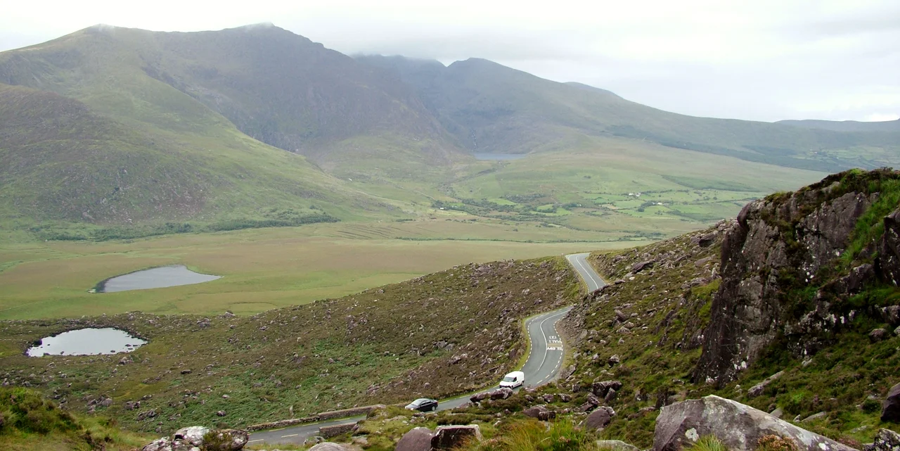

Conor Pass
The road is one lane wide for most of the way up, and the sign at the bottom warns vehicles over two tonnes to turn back. Conor Pass climbs from sea level near Dingle to 456 metres in a few twisting kilometres, threading between the peaks of Binn Dubh and Sliabh Mhacha Ré, past corrie lakes glittering against grey rock. It is one of the highest paved passes in Ireland and one of the most beautiful drives in the country — but 'drive' is a generous verb for what the road actually demands. Locals pull into passing places. Tourists creep. Cyclists, on what is widely regarded as one of the toughest climbs in Ireland, just keep pedalling.
Carved by Ice
The pass exists because ice carved it. During the last glaciation, when the Dingle Peninsula lay buried under sheets of moving ice, glaciers ground out the steep-sided valleys that now flank the road. The corries — bowl-shaped hollows scooped from the mountainsides — hold dark lakes that never quite warm in the sun. Pedlars Lake sits below the summit on the south side. Loch Cruite spreads to the north. The whole landscape carries the unmistakeable signature of glaciation: U-shaped valleys, hanging side valleys, scoured rock and tumbled moraine. Walk a hundred metres off the road and you can feel how recent it all is, in geological terms. The Dingle Peninsula is still recovering, still draining.
The Drive Up
From Dingle town, the R560 leaves the harbour and begins to climb almost immediately. The lower stretches are easy: hedgerows, fields, the occasional farm. Then the gradient steepens and the road narrows. The pavement clings to the slope, with stone walls or sheer drops on the outside edge. Hairpins fold back on themselves. At the summit there is a small lay-by where most drivers stop, partly for the view and partly to recover. Looking back south, the road threads down toward Dingle Bay and the Atlantic. Looking north, Brandon Bay opens out toward Castlegregory, and on a clear day Mount Brandon — the highest peak outside the MacGillycuddy's Reeks — fills the western sky. The view is not a postcard. It is a 360-degree reward.
The Cyclist's Climb
For cyclists, Conor Pass is a benchmark. The full ascent from Dingle gains roughly 410 metres over about 6.5 kilometres, with sustained gradients in the high single digits and pinches into double figures near the top. Add Atlantic weather — wind that can shove a rider sideways, rain that turns the surface treacherous, fog that swallows the next bend — and you have a climb that ranks among the hardest in Ireland. It appears regularly in the routes of the An Post Rás and other Irish stage races. There is no shade. There is no shelter. There is just the road and the slope and the small voice in the back of every rider's head asking what they thought they were doing.
Weather at Altitude
At 456 metres above the sea, the pass is high enough to make its own weather. Clouds catch on the peaks and dump rain on the road while Dingle, just a few kilometres away and a few hundred metres lower, sits in sunshine. Winter sometimes brings snow heavy enough to close the pass for days at a stretch. Spring and autumn bring sudden mist that erases the view in minutes. Even in midsummer, the wind at the summit can be sharp enough to cut through a light jacket. The lesson the pass teaches is humility. Whatever the forecast for Kerry said this morning, the forecast at the top right now might be different — and the road, for all its beauty, does not forgive distraction.
From the Air
Located at 52.18°N, 10.21°W, the pass crosses the central spine of the Dingle Peninsula between Mount Brandon to the west and the Slievanea ridge to the east. Summit elevation 456 metres. Nearest airport is Kerry (EIKY), roughly 40 km east. Recommended viewing altitude 3,000–6,000 feet for a clear sense of the U-shaped valley, corrie lakes, and the snake of road climbing through the gap. Mountain weather can produce orographic cloud well below summit level — check actuals before low passes.
Nearby Stories
- Ballyheigue Castle 1 km away
- Killemlagh Church 2.8 km away
- Pouldergaderry Sinkhole 6.8 km away
- Derreen Garden 11 km away
- Kilkee 59 km away
- The Laki Eruption: The Volcano That Changed World History 1366 km away
- The Northern Lights: The Sky Show That Vikings Thought Was Bridge to the Gods 1469 km away
- Sao Miguel 1935 km away