Cordell Bank: The Invisible Island
Five species of albatross circle above water that hides a secret. Fifty miles northwest of San Francisco, the ocean floor rises sharply from the continental shelf, and a granite mountain climbs to within 115 feet of the surface without ever breaking it. Cordell Bank is an island that nobody can see -- a submerged seamount so rich with life that blue whales travel thousands of miles from their breeding grounds in Mexico and Central America just to feed here. The California Current sweeps cold, nutrient-dense water upward along its flanks, fueling an explosion of krill that draws some of the largest and rarest creatures in the Pacific. Protected as a National Marine Sanctuary since 1989, the bank is a reminder that the most extraordinary landscapes are sometimes the ones hidden beneath the waves.
Following the Birds
George Davidson of the United States Coast Survey discovered the bank in 1853 during a mapping expedition along California's north coast. Sixteen years later, Edward Cordell was dispatched to investigate a 'shoal west of Point Reyes.' He found it the way sailors had always found productive water: by following the birds. Albatrosses, shearwaters, and terns wheeled above the bank in numbers that marked it as unmistakably alive. Cordell measured the depth by lowering a lead weight on a line until it struck bottom, then hauling it back up and counting the feet. His name stuck to the seamount, and his methods -- simple, patient, observational -- set the tone for a place that would resist easy study for another century. Between 1978 and 1986, Robert Schmieder led a series of expeditions that finally produced a detailed portrait of the bank's biology and geology, culminating in a monograph that helped build the case for sanctuary status.
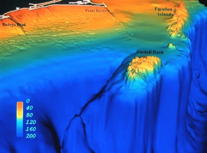
A Drowned World
Between 20,000 and 15,000 years ago, sea levels in this part of the Pacific sat roughly 360 feet lower than they do today. Cordell Bank was not submerged. It was a true island, its granite peaks exposed to wind and weather, surrounded by a coastline that looked nothing like the one we know. As glaciers melted and the ocean rose, the bank sank from view. Today it climbs from soft sediment deposited by coastal erosion, its upper pinnacles reaching within 115 feet of the surface while the average depth sits around 400 feet. Within just seven miles of the bank, the continental shelf plunges to more than a mile deep. That dramatic drop-off is part of what makes the ecosystem work: the steep topography channels upwelling currents and concentrates nutrients in a relatively compact area, turning the bank into an oasis surrounded by comparatively barren open ocean.
The Albatross Capital
Cordell Bank has earned a remarkable title: the Albatross Capital of the World. Five of the fourteen major albatross species have been documented here, including the black-footed albatross and the spectacularly rare short-tailed albatross. That species was thought to have gone extinct after World War II; its global population now hovers at roughly 1,000 individuals, and Cordell Bank is one of the few places on Earth where one might be seen. Twenty-six species of marine mammals frequent the surrounding waters. Blue and humpback whales arrive from breeding grounds thousands of miles to the south, drawn by enormous aggregations of krill. Pacific white-sided dolphins leap through the swells in large pods. California sea lions, northern elephant seals, northern fur seals, and Steller sea lions hunt the bank's abundant squid and juvenile fish. Leatherback sea turtles, themselves endangered, patrol the sanctuary waters.
Seasons of Upwelling
The bank's extraordinary productivity is not constant. It follows a rhythm dictated by ocean currents and coastal winds. In spring and summer, prevailing northwesterly winds drive the California Current southward along the coast, pushing surface waters offshore. Cold, nutrient-rich water rises from the deep to replace it -- the upwelling that feeds the entire food web. Phytoplankton bloom, krill swarm, and the great whales arrive. When late summer turns to fall, those winds die down. The northward-flowing Davidson Current takes over, carrying warm but nutrient-poor water from the south. The feast slows. During winter storm months, rough seas churn the water column, mixing temperatures and salinity across the continental shelf. Nutrients redistribute. The cycle resets. This seasonal pulse is what makes Cordell Bank not just a sanctuary in name but a genuine engine of marine life, its productivity rising and falling with the rhythm of wind and water.
An Expanding Sanctuary
When the sanctuary was designated in 1989, it encompassed 526 square miles of ocean. That was enough to protect the bank itself, but marine ecosystems do not respect neat boundaries. In 2012, NOAA proposed expanding Cordell Bank's borders along with those of the neighboring Gulf of the Farallones National Marine Sanctuary, adding roughly 2,700 square miles of protected ocean stretching north to Point Arena. The expansion passed in March 2015, bringing the sanctuary to approximately 1,286 square miles. From the air, none of this is visible. The bank lies entirely beneath the surface, its granite peaks unmarked by any island or reef. The only signs of what churns below are the birds -- those circling, diving, patient albatrosses that led Edward Cordell to this spot more than 150 years ago and still mark it as one of the most productive patches of ocean on the Pacific coast.
From the Air
Cordell Bank lies at approximately 38.07N, 123.37W, roughly 50 nautical miles northwest of San Francisco and about 20 nautical miles west of Point Reyes. The bank is entirely submerged and invisible from the surface, but seabird concentrations may be visible from lower altitudes on clear days. The nearest airports are Gnoss Field (KDVO) in Novato and San Francisco International (KSFO). Coastal fog is common, especially in summer months during peak upwelling season. Overflying at 2,000-5,000 feet AGL on a clear day offers views of the Marin County coastline, Point Reyes National Seashore, and the open Pacific where the bank lies hidden.
Nearby Stories
- A Wooden Stick in Rohnert Park 1.7 km away
- The Empire Behind the Hills 4.5 km away
- USS Boston (1884) 11 km away
- Sonoma Coast State Park 14 km away
- The Farallon Islands: California's Forbidden Rock 22 km away
- Pixieland 745 km away
- Neskowin Ghost Forest 783 km away
- ʻAkaka Falls State Park 3624 km away